|
Reflections 2010
Series 10
July 7
Oz Preview III: Discovering and Naming Australia - The Indies
| | Lift Away the 20C There’s been so much change in the 20C that it’s hard to appreciate earlier conditions until you lift away the layer of the 20C and see how things were before modern technology. In the 20C if you want to go from Chicago to Frankfurt, you jump into the air in Chicago, flap your arms over the ocean, and descend into Frankfurt. That’s a cute trick, but you cannot appreciate the reality of distance that way, nor the charm of distance, either. Remove the layer of the 20C and watch someone leave Chicago by train or road overland to New York, get on a steamer to Hamburg, then go by train or road to Frankfurt. More time is involved, but it also includes appreciation of the reality of distance. Playing follow-the-dots involves multiple dots and multiple connections between them, not just one single dot at each end. | | | | Removing the 20C also exposes clearly the entrances and exits involved (usually, ports), as well as the orientation some countries have. For surface travel, Ireland is oriented toward Britain, which is oriented toward the continent Cape Town is an entrance, and so is Rotterdam; Peter the Great built Saint Petersburg to have a western orientation for Russia. | | | | Settlement countries in particular have an orientation, including the four we’ve been discussing, which I’ve grouped together under the acronym ANZCUS. All were originally settled from Asia. Canada and the US were part of the prehistoric migration across the Bering Strait from Asia that affected all of North, Central, and South America. New Zealand was settled by Polynesians (Maoris) originally from the Indies and coming down from the north. Australia as well was settled from the Indies, specifically New Guinea. You’ll recall that long peninsula pointing north in eastern Australia, part of Queensland, that includes the northernmost point on the continent. This is the York Peninsula, and it’s separated from New Guinea by the Torres Strait. It’s across this strait that the original inhabitants entered the continent some 40,000 years ago, the Indigenous Australians sometimes still referred to as Aborigines, although use of that word is declining. Thus, the first settlers all across ANZCUS not only came from somewhere in Asia, they all entered their respective areas from the north, which I would describe as the entrance to the country in question at that period in history.
| | | | [Digression: I never cared for the word “Aborigine”, neither by reference nor by sound, often used to describe a member of the first peoples of Australia. I’d just assumed it was a local word, but it turns out to be Latin ab origine, essentially “from (the) origin”. The mainland and Tasmania are inhabited by about 250 different nations of Indigenous Australians forming some 2.7% of the national population. They originally spoke some 250-300 languages of which fewer than 200 remain in use. However, all but about 20 of those still in use are endangered, and could die out.]
| | | | Now let’s consider the Western (European) settlement ANZCUS. New Zealand was first settled quite simply from the north, in the Auckland area, and the population then spread southwest. To this day, North Island has a greater population than South Island, and that population is concentrated on the north end of North Island, near Auckland. Auckland remains the “entrance” to NZ, to the extent that even its airport is the major NZ one. In the air age, major airports usually correspond to the historic entrance region of the country (Fiji being an exception, where the capital and major airport are on opposite sides). | | | | [An interesting contrast to NZ is Japan, which has a very similar shape of islands running NE to SW. You’ll remember that when Japan was first “opened” to the west, since it had no natural “entrance” (certainly not Edo/Tokyo at that time), three different trading centers were set up, in Nagasaki in the south, Hakodate in the north, and Yokohama on Tokyo Bay in the center. Today, of course, the Tokyo/Yokohama urban complex, with harbor and airports, is the country’s “entrance”.]
| | | | The traditional entrance to the US through which came the bulk of European settlers is its original settlement area of the US, the four bays that developed a string of cities now known as the “Northeast Corridor”, cities from Washington to Boston, centering on New York, which should not be surprising. Thus the US is traditionally oriented east toward Europe, with a secondary orientation on the west coast.
| | | | The surprise comes with Canada, due to its unique geography. Let’s use the metaphor of a large estate. A traveler arrives at the front gate and spends some time visiting with the gatekeeper. He then proceeds up the main road to the manor house. At the far end of the estate is a back entrance.
| | | | The Maritime Provinces are Canada’s traditional historical “entrance”, including Halifax (the “gate”) serving as the entry point for large numbers of immigrants. The Saint Lawrence river, then, including road and rail routes on its banks, is the driveway up to the manor house of Québec and Montréal, later Toronto and Ottawa. It’s quite a unique situation for the main center of the country, it’s “entrance” not to be coastal, but to instead feed off of a de facto entrance further over on the coast. The Vancouver/Victoria area on the Pacific serves as the “back door” to the “estate”.
| | | | As for the Western discovery and settlement of Australia, I have to admit, I’ve been up until now quite confused. The orientation of Australia today is the population center on the southeast coast centering on Sydney, which actually centers on a “Southeast Corridor” of cities). | | | | But something seemed wrong to me. Isn’t the east coast the “wrong side” for European discovery and settlement? Given the barrier of the Americas plus the width of the Pacific, wouldn’t Europeans have arrived from the Atlantic, past Cape Town and the Cape of Good Hope, coming from the WEST? Isn’t it counterintuitive that the “far side” of the continent was settled? | | | | In retrospect from what I’ve now discovered, I see it was inaccurate to state in 2009/12 that Tasman, sitting in the Tasman Sea between Australia and New Zealand) named the two places after two Dutch provinces, New Zealand and New Holland (Australia). First, it was Dutch cartographers back in the Netherlands who named New Zealand, and the Australia that Tasman named New Holland was not in the Sydney area. As a matter of fact, while Tasman visited Tasmania, he never visited the east coast of the mainland at all. Finally, the thing that led me to the facts about the Western discovery of Australia was when I was planning my trip from Perth to Cape Leeuwin, the most southwesterly point on the continent. If European explorers were somehow headed for the east coast, why did this western cape have such a very Dutch name?
| | | | Western discovery of Australia took place up to two centuries earlier before any settlement, and we have to consider both sides of the continent. It is also logical that, given the size of the oceans, Australia might have been first reached by means of “stepping stones”, such as the nearby islands of Indonesia, or “the Indies”, just as was the case with Native Australians.
| | | | The Indies We’ve got to study the Indies to know more about the entire region. But that brings up even more issues. Why were those islands, which are not near India, called the Indies in the first place? | | | | The word Asia, of Greek origin, was very limited in use in the ancient world. It referred to Anatolia, of Asia Minor, today the main part of Turkey. In other words, “Asia” originally designated an area of the eastern Mediterranean, and there was no collective name for the countries beyond the eastern Mediterranean; they were simply Arabia, Persia, and, at the “end of the earth”, India. Even the Asians themselves had no collective name for the area. It is amusing to picture how a name limited to what is today just Turkey eventually spread to include everything from there to Japan.
| | | | But before the name spread, trade routes were established beyond Arabia, then beyond India. Eventually, the term Greater India was used to describe the culture and religions of India migrating to the areas “beyond India” starting in the mid-15C. Note the importance of directionality here; in these early centuries, with traders coming from the West, India was reached on its west coast, which would have been its orientation, and everything else was “beyond” that. Thus, Greater India also included the regions beyond it, that is, Southeast Asia, and the nearby islands. These islands were therefore referred to as the Indian Islands, shortened to the Indies.
| | | | [Aside One: Columbus had been looking for a direct route to the countries of Asia, but that word wasn’t in use yet then. When he found islands to the southeast of North America just as the Indies lay to the southeast of “Asia”, he referred to these new islands as the Indies as well, and, for further precision, the West Indies. That had the affect of the original Indies then being back-named the East Indies. The term West Indies is almost dead, being used in the odd address (“Barbados, W.I.”), but people instead talk of visiting the Caribbean, and never the West Indies (odd: visiting the water and not the land?). Also, the terms Indies and East Indies are now historical, having been converted into the name of the country encompassing most of them, Indonesia (indo-nes-ia is India-island-country).]
| | | | [Aside Two: It would also seem that, as China became a known entity, and it was felt that Southeast Asia was influenced by both Indian and Chinese culture, the name Indochina developed to refer to the mainland region.]
| | | | [Aside Three: Speculation and what-ifs: if the continent HAD been called Asia since ancient times, these islands, instead of being called the Indian Islands, could have logically been called the Asian Islands (what a sensible name!), then shortened to the Asians. The Caribbean could then have been called the West Asians as opposed to the East Asians. Native Americans, instead of being called Indians, would have been called Asians, which brings us around full-circle, since they had immigrated over the Bering Strait from Asia in the first place!]
| | | | Maluku Islands But what was it precisely that was so special about the Indies? Principally it came down to a group of small islands called the Malukus. | | | | We’ve looked at the Indies when talking about the Kwai. We recognize in white the Philippines on the right, and the Malay Peninsula on the left, with the Strait of Malacca facing Sumatra. Then comes Java, Bali, and the other islands in that chain. Above them is huge Borneo, but then note those light green tiny islands between serpentine Sulawesi and New Guinea. These are the Maluku Islands. How can they be so important to world history? Well, their older, perhaps more international name is the Moluccas, but more helpful yet is their nickname, the Spice Islands, one of the most important trading items in the world at the time. Spices had high value, and generated high profits. The Maluku/Spice Islands were particularly known for cloves, nutmeg, mace, as well as others. (I remember visiting the spice plantation on a small-group tour in Zanzibar (2008/12) and being fascinated by seeing spices coming off trees and shrubs.)
| | | | The Portuguese were early players in the spice trade, but the Dutch and British soon got deeply involved as well in the 17C and 18C, before spice plants and seeds were smuggled out to other islands around the world, diminishing the importance of the Spice Islands. Yet during the height of their importance, the tiny island of Run (3 km x 1 km) in the Malukus, famous for the nutmeg and mace once found exclusively in these islands, had been claimed by both the Dutch and the British. At about the same time, the island of Manhattan (New Amsterdam) had been illegally taken over from the Dutch by the British in 1664. In the 1667 Treaty of Breda, the British yielded Run and its spices to the Dutch, while the Dutch yielded Manhattan to the British. Thus did the importance of the spice trade affect the history of New York. When you review history, you find that everything is interconnected.
| | | | Initial Western Discovery of Australia Now that we’re aware of the Indies being the stepping stones leading to Australia, based on the Dutch colonial and spice trade interests there, we can understand how the initial discovery took place. It should not be surprising that Dutch ships probing the outer edges of the Dutch East Indies, might come across Australia, thinking it’s another island. | | | | The Duyfken & Willem Janszoon The Dutch ship involved was the small Duyfken (DÖIF.ke), meaning Little Dove, which in modern Dutch would be Duifje. It was captained by Willem Janszoon, and had been sent out from Java to search the islands to the south and east. In 1606 this ship came across and charted the shore of that same Cape York Peninsula that points north towards the Indies, making landfall at the Pennefather River in the northwest of the Cape. This landfall is credited as being the Western discovery of Australia. No settlement or land claim was made based on this landfall, though, which is typical of Dutch encounters with Australia, since their efforts continued being concentrated in the Indies. Eventually it was the west coast of Australia that became the main point of Dutch encounter. | | | | The Eendracht & Dirk Hartog A ship called the Eendracht (ÉN.drakht), (meaning “harmony, concord, unity”) captained by one Dirk Hartog, is credited with making, accidentally, the second European landfall on the Australian continent, in 1616, about ten years after the Duyfken. The Eendracht left the Netherlands and sailed around Africa’s Cape of Good Hope headed for the Indies. Crossing the Indian ocean Hartog found he made better time following a more southerly route than usual. In addition, he may have been blown a bit more to the south than he planned. On 25 October 1616 he sighted land, and he and his crew landed on what is now called Dirk Hartog Island off Shark Bay on the central west coast of Australia. He spent three days there, and as a memento of his visit, he had a pewter plate engraved which included the dates of arrival and departure, the name of the ship, and his name. He attached the plate to a post set in a rock cleft (now called Cape Inscription [see map]), did some more charting of the coastline, and departed for Java. | | | | The plate lay untouched right where it was for another 81 years, until a Flemish captain, Willem de Flamingh, rediscovered it in 1697 (amazing, but not totally by chance, since ships’ logs were very carefully kept). The post had rotted away, and the plate lay half-buried in sand. De Flamingh took the plate, replacing it with one if his own and copying the original inscription onto it. He added his own data, and installed it in the same spot, nailing it to a tree trunk. The original plate, now known as the Hartog Plate, is the oldest known written artifact of Australia’s European history. It is today located amongst the paintings of the Dutch Golden Age, in none other than the Rijksmuseum Amsterdam.
| | | | In 2000, the Hartog Plate made a return visit to Australia 303 years after it had left, but to the opposite side of Australia. It was lent to the Sydney Maritime Museum, and the Australian authorities were wondering if it shouldn’t stay in Australia, but the Dutch authorities made it clear the plate wasn’t for sale. Apparently, as important as it is to the history of Australian discovery, it’s also important to Dutch maritime history. | | | | Significant also is that Dirk Hartog gave a name to the region of the coast he had visited, based on his ship’s name. He called it ‘t Land van d’ Eendracht [Land was also spelled Landt, and de appears as d’]. Thus “The Land of the Eendracht”, which also appeared as Eendrachtsland, was the first Western name for at least a part of Australia, although the name did not endure beyond the end of the 1600’s. | | | | Hessel Gerritsz’s Maps In this period, Dutch cartographers had great renown, and many consider Hessel Gerritsz, who mapped many areas of the world, the best of them. In 1617 he was appointed the first exclusive cartographer for the Dutch East India Company, and in 1618 Gerritsz produced a superior map of the Indonesian islands, which for the first time, included parts of the Australian coast. Although continuing to be dated 1618, this remarkably accurate map was later updated with further discoveries through 1628 along the west and south coasts, and shows for the first time the clearly identifiable outline of Australia. This is the Hessel Gerritsz map (click to enlarge). Note the accuracy of the Indonesian islands, with the Malay peninsula (in purple) at the top left, followed by Sumatra (green) and Java (purple). Australia is identified by the names of several ships that had studied the coastline, both before and after 1618, of which we’ll discuss two. Gerritsz also made a more detailed map of just the Australian coast in 1627, with additional commentaries (see below). | | | | We start with the oldest discovery here--‘t Land van d’Eendracht of 1616. It centers on (with a variant spelling) Dirk Hartogs Ree. A ree is a roadstead, and I had to check just what a roadstead is: while a harbor offers good protection as an anchorage, a roadstead is more open, but still offers adequate protection; so this roadstead would be what is today Shark Bay. As to two other places noted in Eendrachtsland, the Houtman Abrolhos (discovered 1619) are an island chain still known by that name, while it is not known today just what river Willems Rivier might have been referring to.
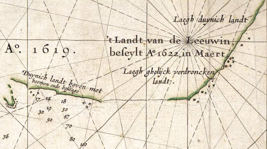
| | | | The other “land” mentioned on the map is to me of importance because it’s the only ship or “land” name that’s still used, and still refers to its area--sort of--although most people do not realize it’s the name of a ship. To clarify, let me tell the story backwards: the southwesternmost point in Australia today is called Cape Leeuwin, where the Indian Ocean meets the Southern Ocean. The Margaret River wine area is in this corner, and the name Leeuwin is common in the region; even one of the principal wineries (which I’ll be visiting) is called Leeuwin Estate. Therefore the name of the ship that discovered and mapped this area in 1622 remains alive to designate it, except that most people consider that everything is named after the cape, and don’t realize that the cape--and former “land”--are named after a Dutch ship, or for that matter, don’t even realize that the name is Dutch.
| | | | “Leeuw” is the Dutch word for “lion”; “-in” makes words feminine, so “Leeuwin” is “lioness” (German Löwe/Löwin). While in Dutch Leeuwin is pronounced LÉ.u.vin, in English the pronunciation is shortened and altered to LU.win. Unfortunately, the log book of the Leeuwin was lost--it is not even known who captained the ship--so very little is known of its voyage. Actually, almost all of what is known today is because of the two Gerritsz maps. | | | | The larger Gerritsz map we saw above, describing this corner of the continent, says only: ’t Land van de Leeuwin, A°. 1622 aengedaen. A°. of course stands for Anno/Year; the other word, spelled today “aangedaan”, means “called at” or “put in at”. However, there are a few more comments made on Gerritsz’s 1627 specialized map of just the Australian coast, of which this is a detail.
| | | | Gerritsz turned this coastal map sideways, so North is roughly to the left, and Cape Leeuwin is around the bend on the right. To the left is a different 1619 discovery, only theoretically connected to the Leeuwin area by a dotted line, but its comment, in antiquated spelling, means “Duned land above with trees and underbrush”. It says on the right the Land of the Leeuwin was reached Anno 1622, in March; above that (to the east) it says “Low, duned land”, and below (to the west) “Low, seemingly submerged land”. The two maps we’ve now looked at indicate the oldest written observations on this region in existence. | | | | Terra Australis This is a good time to take a moment to reflect further back in time still to see what people knew and didn’t know about the southern hemisphere. The concept of Terra Australis Incognita (“Unknown Southern Land”), often shortened to just Terra Australis, goes back to Aristotle, and was expanded by Ptolemy, who believed that the Indian Ocean HAD TO be enclosed by land to the south in order to balance all the land of the (known) continents in the northern hemisphere. The concept of necessary balance might seem amusing, but the theoretical existence of a southern continent continued and was even expanded in the Renaissance. This 1587 map of the world shows in orange the hypothetical southern continent labeled Terra Australis, but none of it at this point had yet been actually seen. It was known that Africa didn’t touch it, since navigators had sailed around the Cape of Good Hope. This map still shows that South America might touch it, but in 1615 the first navigation around Cape Horn was successful, showing that South America wasn’t attached to it, either. But beyond that, nothing was known and the word Incognita was very rightly applied, as it was very “unknown”. It’s so easy from the know-it-all viewpoint of modern times to be surprised that, as various places were discovered, no one knew how they were--or were not--attached. For instance it wasn’t known if New Zealand was attached to the mysterious continent, nor, Australia, nor even if, as the west and east coasts of Australia were gradually discovered, if they were the same island or continent or two different ones. And for the longest time, it also wasn’t known that Tasmania was a separate island and it was not attached to the mainland. | | | | Abel Tasman It is thought that the larger Gerritsz map was the one that Abel Tasman used on both his voyages (1642-3 and 1644) some two decades later around Australia and to New Zealand. Tasman was employed by the Dutch East India Company and was asked to obtain whatever knowledge he could of the regions of Terra Australis. This map shows Tasman’s routes.
| | | | His first voyage swung around to the south and he stopped at what is today called Tasmania, and then stopped in New Zealand. Tasman and his party were the first Europeans to reach either Tasmania or NZ. Not on this voyage--or ever--did he visit or sight the east coast of Australia, but then he had no way of knowing if Tasmania was part of such a possible coast or not. Only on Tasman’s second voyage in 1644 did he actually encounter the Australian mainland. He followed New Guinea to the York Peninsula and then visited and charted the north coast. It was on this voyage that he used the name Nova Hollandia (Nieuw Holland, New Holland).
| | | | As for naming, the name Nova Hollandia was given to the Australia he saw, in the west, since he never saw the east coast. Still, he meant the name to refer to the entire continent, yet with the later British settlement of the east coast, it eventually was limited in meaning to the west. Even after the west became British, the name Nieuw Holland was used in the Netherlands until the end of the 19C, when it was finally abandoned there, too. He did not name New Zealand--cartographers back in the Netherlands did. He did name Tasmania on arrival in 1642 after Anthony Van Diemen, who was the Governor-General of the Dutch East Indies and who had sent him on this voyage. It became Van Diemen’s Land (actually Anthoonij van Diemenslandt), and was still not known to be an island. It was included within the colony of New South Wales on the latter’s founding in 1788, but was settled only in 1803. In 1825 it became its own colony, and in 1856 the name was changed to Tasmania.
| | | | The sea Tasman crossed between Tasmania and NZ is appropriately named the Tasman Sea, but nicknamed The Ditch, so that “crossing the ditch” is today a casual reference to any travel between Australia and New Zealand.
| | | | James Cook We’ve talked about James Cook, usually referred to in English as Captain Cook, in Fiji, Tahiti, and Hawaii, where the monument to him, located where he died in 1779, is visible on the Big Island across Kealakakua Bay near the town of Captain Cook (2008/25). He is known for his three voyages, the first shown here in red, the second green, and the third in blue, including the part completed by his men after his death. Of significance to this discussion on the first voyage (red) is Cook’s circumnavigation of New Zealand, proving it isn’t connected to another continent, and then his landfall on 29 April 1770 on the southeast coast of Australia at Botany Bay, today just south of Sydney. This was finally the first European landfall on Australia’s east coast. From Botany Bay he proceeded northward along the coast to Torres Strait just north of the York Peninsula, where he landed on what was then called Possession Island, where he claimed as British territory on 22 August 1770, as described in his journal, “the whole Eastern Coast by the name New South Wales”. This indicates he was aware that this eastern coast was continental in size and related to a certain western coast. Still, no one knew yet that Tasmania was an island.
| | | | Also of significance here was his second voyage, which was specifically commissioned by the Royal Society to search for the mythical Terra Australis, and which circumnavigated the globe at a very southern latitude, being the first to cross the Antarctic Circle. He also mapped and took possession of South Georgia (2006/15) for Britain, and came close to encountering the mainland of Antarctica, but didn’t. This voyage put to rest the myth of Terra Australis.
| | | | As I was researching this article, I happened to watch the British version of the Antiques Roadshow one evening, and some one presented for appraisal a dark, rather small world globe. The appraiser was able to date it as 17C-early 18C, since it showed the west coast of Australia, making it post-Gerritsz (1616/1628), but there was still a huge blank where the east coast should have been, making it pre-Cook (1740). The southwestern corner of Australia was marked in English “Lewin’s Land”, in that spelling. It was very fulfilling to be able to recognize as part of the appraisal just what I’d been researching, and also to completely understand why the appraiser was able to date the globe as he did.
| | | | Matthew Flinders Matthew Flinders was a successful navigator and cartographer, who had left England, as he himself stated, induced to go to sea after reading Robinson Crusoe (published 1719), which would seem to be another example of life following art. He sailed with Captain Bligh (1791-3, post-Bounty), transporting breadfruit from Tahiti to Jamaica (2009/12), and as part of that voyage, had his first visit to Australian waters when Bligh stopped in 1792 in Tasmania. Posted in 1795 to Port Jackson (Sydney), he became known as a navigator and cartographer, and became friends with a ship’s surgeon, George Bass. | | | | In 1798, Flinders was ordered to sail beyond some islands northeast of Van Diemen’s Land/Tasmania and “should a strait be found, pass through it, and return by the south end of Van Diemen’s Land.” Flinders found such a strait, which shortened the route from England by several days. He named it Bass Strait after his friend, and in honor of having found the strait, the largest of those northeast islands in the strait would later be named Flinders Island. But looking at his discovery from another point of view, he finally proved that Tasmania was an island, so that when Tasmania’s capital of Hobart was founded a few years later in 1803 as the second-oldest city in today’s Australia, it was by then clear that Hobart was not on the same coast as the oldest settlement, Sydney (1788).
| | | | Back in England, the influential scientist Sir Joseph Banks convinced the Admiralty to send out a scientific expedition under Flinders to chart the coastline of New Holland. Using the usual southern route, he first reached the southwest corner of the continent. You will recall that both of Gerritsz’s maps showed this area as a gentle curve, with some offshore islands. A French explorer who sighted the cape in 1791 thought the cape was located on one of these islands (not odd, since Cape Horn at the bottom of South America is on an island, which I’ve circumnavigated). In reality, though, the area looks as indicated on this modern map of Margaret River. | | | | Note the unusual projection of this area westward, and its proximity a few hours from Perth. Margaret River can refer to the river leading out to the cape area, more likely to the town of Margaret River, and most likely to the Margaret River wine area covering much of the region. Flinders arrived here on 6 December 1801 (very much pre-Margaret River), studied the area, and concluded that the “island” that the cape was on was actually connected to the mainland. He wrote: “This supposed isle is, therefore, what I denominate Cape Leeuwin, as being the south-western and most projecting part of Leeuwin’s Land.” He was therefore aware of the traditional Dutch name for the region, and was not only the person who named the cape, but the person who preserved this old Dutch name for posterity, even though people hearing “Leeuwin” today think “cape” and not “Dutch ship and the region named after it.” The bay just east of and protected by the cape was named Flinders Bay in 1829-30. On the Margaret River map, the small headland due south of Margaret River is Cape Leeuwin, as seen here from the east over Flinders Bay. The Southern Ocean is to the left, and beyond, to the right, is the Indian Ocean.
| | | | The headland north of Margaret River on the map is Cape Naturaliste, which encloses Geographe Bay to its east, and the whole region is part of Leeuwin-Naturaliste National Park. But my interest as always is in those names, which turn out to be French. A naturaliste is of course a naturalist (natural history expert), and a géographe is a geographer, yet the two locations aren’t named directly after scientists, but rather, in a long Australian tradition, after ships. Two French ships on a scientific expedition arrived in the area at about the time Flinders did, resulting in a meeting of scientists and explorers. Le Cap du Naturaliste was named after Le Naturaliste, and la Baie du Géographe was named after Le Géographe.
| | | | Flinders continued to Sydney, then set sail to the north and along the north coast. Finding the ship was damaged, he felt he had to return to Sydney rather than go directly back to England, still he decided to return to Sydney via the west coast. In doing so he was the first person to circumnavigate Australia.
| | | | Naming Australia Aside from the above, Matthew Flinders is known for being the principal promoter of adopting the name Australia. He did not invent the word, which had been around fleetingly for some time as a word derived from Terra Australis.
| | | | [It’s worth reviewing some roots. The Northern Lights are the Aurora Borealis (more accurately Northern Dawn), with the root boreal- referring to the north. Similarly, there’s an Aurora Australis over Antarctica (Southern Lights/Dawn), with the root austral- referring to the south. This root is in use elsewhere, as we found discussing Tahiti and French Polynesia, which includes an archipelago to the south, the Îles Australes or Austral Islands. In the same way as this root was applied to Australia, a country in the north could have been named Borealia, or to push the concept to the extreme, a country notably in the east or west could have been Orientalia or Occidentalia. Of all of these fantasies, only Australia actually developed as a name.]
| | | | But just as Terra Australis was a vague reference to some place in the south, so had the name Australia been. Flinders was the first one to specify that he wanted the continent he had circumnavigated to be the one to get the name Australia. In 1804 he prepared a map of the continent that was the first map that used the label Australia, and sent a copy to Sir Joseph Banks, his patron. I’m delighted to have found, from the National Library of Australia, an online copy of the 1804 Flinders map of Australia. It startles in its simplicity, since it’s all coastline, although not as minimalist as the Gerritsz maps of almost two centuries earlier. It’s all there, Shark Bay with Dirk Hartog’s Island, Cape Leeuwin, Van Diemen’s Land, Bass Strait. But it’s the labeling that’s of significance: Tasman’s New Holland in the west, Cook’s New South Wales in the east, and in the center, the older Terra Australis and the proposed Australia. If you have a feeling for these sorts of things, it gives you goosebumps. | | | | Flinders continued to promote the name, but on arriving back in London in 1810, he found that Banks did not approve of the name and had not even unpacked the map. Still, in 1814 Flinders’ A Voyage to Terra Australis was published. I used Project Gutenberg online to leaf through parts of a copy of it, from which I’ve taken some quotes, including his naming of Cape Leeuwin, as quoted above. The following excerpt from his Introduction gives insight over the intervening two centuries, including Flinders trying to be fair as possible about all naming possibilities:
| | | | | | The voyages which had been made, during the seventeenth and eighteenth centuries, by Dutch and by English navigators, had successively brought to light various extensive coasts in the southern hemisphere, which were thought to be united; and to comprise a land, which must be nearly equal in magnitude to the whole of Europe. . . .
The vast regions to which this voyage was principally directed, comprehend, in the western part, the early discoveries of the Dutch, under the name of NEW HOLLAND; and in the east, the coasts explored by British navigators, and named NEW SOUTH WALES. It has not, however, been unusual to apply the first appellation to both regions; but to continue this, would be almost as great an injustice to the British nation, whose seamen have had so large a share in the discovery, as it would be to the Dutch, were New South Wales to be so extended. . . .
It is necessary, however . . . , that so soon as New Holland and New South Wales were known to form one land, there should be a general name applicable to the whole; and . . . I have . . . ventured upon the re-adoption of the original TERRA AUSTRALIS; and of this term I shall hereafter make use, when speaking of New Holland and New South Wales, in a collective sense; and when using it in the most extensive signification, the adjacent isles, including that of Van Diemen, must be understood to be comprehended.
|
| | | | So far, he urges that Van Diemen’s Land/Tasmania be included in the naming, and he seems to be yielding to using the traditional Terra Australis, which he knew that Banks, his patron, wanted. He goes on: | | | | | | There is no probability, that any other detached body of land, of nearly equal extent, will ever be found in a more southern latitude; the name Terra Australis will, therefore, remain descriptive of the geographical importance of this country, and of its situation on the globe: it has antiquity to recommend it; and, having no reference to either of the two claiming nations, appears to be less objectionable than any other which could have been selected.* |
| | | | Having circumnavigated the continent, Flinders knew it wasn’t connected to some mythical Terra Australis, which he decides here does not exist. This conclusion he makes here in 1814 would soon be revealed as a mistake, since Antarctica was sighted within the hypothetical area of Terra Australis just six years later, on 27 January 1820 by Russian naval officer Fabian Gottlieb von Bellingshausen. Odd as it may seem, the Terra Australis hypothesized by Aristotle and Ptolemy did really exist, although it was not as large as had been depicted on Renaissance maps. Antarctica not yet being in play, Flinders then (reluctantly, as we know) decides to promote Terra Australis. But you must notice that little asterisk at the end of the paragraph, which leads to this footnote: | | | | | | * Had I permitted myself any innovation upon the original term, it would have been to convert it into AUSTRALIA; as being more agreeable to the ear. . . . |
| | | | He couldn’t help himself, despite Banks. He liked this name better. The word appears on the Flinders map, but then this footnote is the only occurrence of the word “Australia” in the Flinders book. | | | | Flinders had urged adopting “Australia” as early as 1804. He died in 1814 the day after the book was published. Although the name was already known, the book was widely read, and gave the name currency, so Flinders is credited with popularizing the name, which became gradually accepted over the following years. The name “Australia” was adopted formally by the Admiralty ten years later, in 1824, without Flinders ever knowing of his success. | | | |
| |
|
|
|

