|
Reflections 2010
Series 1
February 7
Japan Redux - Normandie - Castello Plan Redux
| | Now into the new year I find myself spending weeks and weeks planning and fine-tuning the major trip later this year centering on Australia, but we can pause to catch up on some postings, starting with a follow-up or two left over from 2009.
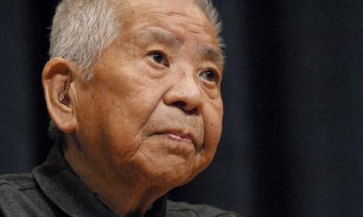
| | | | Japan Redux: Twice Bombed Right after New Year’s it was reported that on 4 January a 93-year-old Japanese named Tsutomu Yamaguchi had just died of stomach cancer. His story was particularly unusual, since he was not only an atom-bomb survivor, but was referred to as “twice bombed”, since he had survived the bombings of both Hiroshima and Nagasaki. Apparently quite a number of people have claimed to have been twice-bombed, but he was the only one officially acknowledged as such. While in 1957 he was recognized by the Japanese government as a survivor of the Nagasaki bombing, it was only last year, in March 2009, that he was also recognized as a survivor of the Hiroshima bombing. | | | | Apparently he had been a 29-year-old engineer working for Mitsubishi Heavy Industries (I remember that their being located in Hiroshima was a major reason for it being chosen for the attack), and was just concluding a three-month working visit to Hiroshima from his hometown of Nagasaki on 6 August 1945. He was actually on the way to the rail station, when he realized he’d forgotten something. He was getting off a streetcar when the first bomb was dropped. Despite his wounds, he returned home on the following day, and went back to work on 9 August. He was, ironically, in his Nagasaki office describing his Hiroshima ordeal to his supervisor when he saw another flash, but he was not wounded the second time.
| | | | You’ll have to forgive a little gallows humor if I observe that his experience just shows that some people always walk around with a black cloud over their heads. Actually, I’m not the first to see the humor of the situation; on Weekend Update on Saturday Night Live, it was claimed that he was the originator of the phrase “Oh, no, not again!”
| | | | Japan Redux: Analysis/Synthesis In Japan I learned something about myself and how I like to travel. It’s part of pondering what I learned and what I want to bring up now in regard to the Japan visit. I’ll say again that the visit to Japan and Taiwan was breathtakingly simple, which amazed me. Although I’d prepared myself in advance as always with appropriate maps, still I had no trouble whatsoever navigating myself around or between cities because of the writing system, which is what I’d feared. Everything of importance was romanized, and beyond that, so much that was needed to get around was in English. It’s difficult to point out the place in Japan I enjoyed most, and Nikko and Hiroshima/Mayajima are certainly among the candidates, but I think that the most perfectly self-contained experience was in Takayama in the so-called Japan Alps (2009/40). The calm, uncrowded town in the autumn weather, that marvelous historic commercial street overflowing with interesting shops, the street food I tasted, the visits to the historic government building and historic merchant’s house, all left a very memorable impression. It got even better when I not only found that restaurant that specializes, of all things, in sukiyaki, but then found that the lady owner/chef and I were the only ones at the tiny counter, yet we got along fine without speaking each other’s language. I was also pleased when I could tell she was complimenting me on my use of chopsticks, with which I admittedly have no trouble. | | | | When in that Takayama posting I was leaving town and wrote “Day 17: Train Day” I left out something which was actually quite memorable to me, but dismissed at the time writing about. As I’ve pondered it since, it now seems very worth writing about.
| | | | While I was slowly working my way through the Kusakabe Merchant’s House, having all the time in the world, I noticed another visitor. The autumn weather did call for at least a jacket, but he stood out because of his dark knit cap and coat. He also stood out because he was possibly the only other Westerner I saw in Takayama, tucked away up in the mountains in the off-tourist season, but because of how intent he was on taking pictures. He took a lot, and would kneel down on the chilly tiles for better angles. It was his deep interest in the interesting architecture and interior decoration of the building that caught my attention most, probably because it seemed to equal my own. But we had no occasion to talk.
| | | | The next day, “Day 17: Train Day”, I was waiting on the Takayama train platform. There were quite a few Japanese there ready to travel, and curiously, Mr Knit-Cap was standing nearby. It was at this time we introduced ourselves and spoke. I don’t remember his name, but it might have been John, so I’ll use that. Where was John from? What would be a wild guess? Well, as I find so often is the case nowadays, John was Australian. He was visiting Japan for a while in preparation for marrying a Japanese woman he knows and moving to Japan permanently. When I asked him where in Australia he was from, it turned out to be Margaret River, which is south of Perth on the west coast, and which I’m planning to visit.
| | | | When I told him I was planning a visit to Australia, it was his question that non-plussed me and that got me thinking. He asked “Which part?” I was taken aback, because it never had occurred to me to go to any “part”, and so I answered “All of it”, which then seemed to nonplus him. I added “North and south, east and west, by rail”, which made him raise his eyebrows. And that’s where I understood something, first about him, and then about myself. | | | | There is no doubt in my mind that John was a serious Traveler, capital T, as I also consider myself. No nonsense with him. I could see that in his extra care in wanting to photographically document the house, and also in the fact that he was just completing a full week in Takayama. I believe he was also going to stop in just one or two other places before going home before moving back to Japan.
| | | | Thinking it over, I begin to comprehend Traveler John’s methodology, and I see it as similar to how a scientist might use the scientific method of analysis to learn about something. John analyses by looking at the microcosm, the “smaller world”, and then generalizing. He might have learned as much by his full week in Takayama (plus another stop or two) as I did in my longer trip. On the other hand, I can’t operate like that. I loved Takayama—I already said it was my favorite stop--yet my two complete days there fulfilled me completely; I would have gotten bored with more time there, so off I was to Nara. As you know, I went to all the locations on Japan’s four major islands that interested me, north to south (in narrow Japan you can’t do too much east to west). That’s the way I always visit a new place if at all possible. To me, that’s so obviously the way to do it that it wasn’t even worth mentioning, until it came up in this conversation. So what I realized about my travel methods is that I use the opposite scientific method from John, synthesis. I look at the macrocosm, the “larger world” for insights, and then synthesize what I’ve learned, or tie together numerous impressions. In other words, John expands his smaller-world insights and I compress my larger-world insights, each of us achieving thereby a reasonable understanding of the country in question. I suspect we both come out the same at the end, but you can understand my startled reaction to the question “Which part?” and his dubious reaction to the answer “All of it”. My, the things that Travelers can learn about themselves by chance encounters on a far-off autumnal railway platform.
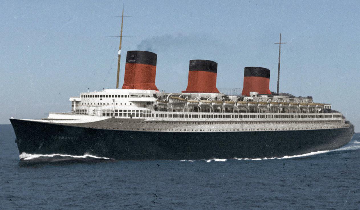
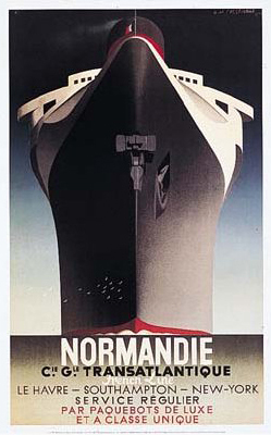
| | | | Normandie Lecture In December, when I discussed the annual party at the South Street Seaport Museum (2009/45), I said I got to know one of the members, Dave, and we agreed we, with his wife Leslie, would attend both the lecture and reception in January at the Museum about the iconic 1935 French luxury ocean liner Normandie, shown here arriving in New York on her maiden voyage in June 1935. In December I described the Normandie as “once the largest and fastest passenger ship in the world, an Art Deco masterpiece, that burned and capsized at her Pier 88 dock in midtown New York in 1942”. The speaker in January was John Maxtone-Graham, who’s written extensively and definitively about many ships, including the Normandie in 2007, and whose first book in 1972 was The Only Way to Cross, a phrase that just rolls off the tongue. He described the history of the ship and how it was a Russian émigré whose revolutionary new design it was, a fact that still tends to irk the French. He discussed the Art Deco period in general, as reflected in this famous 1935 Normandie poster, and the Art Deco outfitting of the Normandie in particular, including the glass fixtures and columns by Lalique in the dining room and Grand Salon, some major salvaged pieces of which are now in the Metropolitan Museum of Art, while other salvaged pieces of furniture ended up rotting away, forgotten in someone’s garage. Everything that had been salvaged was taken as the ship was being converted to wartime use in New York, and before the fire. He told how he personally managed to acquire the ship’s wheel some time after the fact, and eventually donated it to South Street, who will be including it in their upcoming exhibition on the Normandie, which Lalique is helping to sponsor. He added that he is convinced that the tragic fire was a genuine accident caused by workers, and that the sabotage stories are urban legends. | | | | An example of the salvaged/lost dichotomy involves the Normandie dining room’s two giant doors, which were each two decks (6 m / 20 ft) high, and had 10 large bronze medallions, five lined up vertically on each door. The doors are gone, but the medallions were salvaged, and are now located at a church in Brooklyn Heights. Six were installed on the church’s pair of front doors, and four on its pair of side doors. However, the bit of text under each medallion identifying the scene was also lost.
| | | | Introducing Maxtone-Graham was Bill Miller, the authority on ocean liners and current Curator of 20C Maritime History at South Street. I’ve traveled and enjoyed Bill’s lectures on three different ships, the most recent one being the Queen Victoria just a year ago between New York and Los Angeles. I now learn that Bill has made about 350 ocean voyages, which means I still have quite a way to go to catch up with him.
| | | | Afterwards Dave, Leslie and I went out to a most enjoyable dinner at a nearby Irish pub. I discovered that Leslie is director of a school of music in Manhattan which specializes in teaching music to the hearing-impaired, one of the topics, including Dave's Amtrak connections, that led to a variety of interesting conversations.
| | | | Normandie I have since found a remarkable amount of available video footage of the Normandie and its demise. Coming from the 1930’s much of it is black-and-white, but the French Line (its international name; in France it was always the Compagnie Générale Transatlantique, now merged out of recognition), as Maxtone-Graham pointed out, did go to some expense to prepare some advertising footage in color. I’ve sifted through a lot of material on YouTube, much of it tributes to the ship, much of it duplicates of other footage. For those readers interested, each of the following four videos is about 3 to 4 minutes in length. | | | | | | | | Here is what is left of the burned hulk of the Normandie in 1946 on the way to the scrapyard. Sic transit gloria mundi.
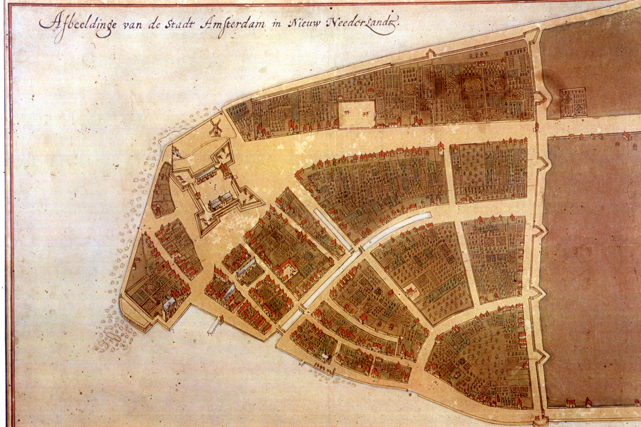
| | | | Castello Plan Redux We first discussed the Castello Plan last year (2009/24) in conjunction with the settlement of Nieuw Amsterdam, which eventually became New York. 2009 was also the Quadricentennial of Henry Hudson’s visit, so we also talked about his arrival in 1609 on the Halve Maen/Half Moon. The Dutch had settled New Amsterdam at the southern tip of Manhattan Island in 1624, and based on a census made in 1660, a detailed map was drawn up, including all the buildings in the village, with an accompanying list of all the residents. By 1667 the map had reached Amsterdam, where a cartographer compiled a series of maps into an atlas, which he sold to Cosimo de’ Medici, and off the map went to Italy. It wasn’t until 1900 that the Nieuw Amsterdam map was found in the Villa di Castello near Florence, hence its contemporary name. Although the original Castello Plan is a bit dull in color, the 1916 redraft that one regularly sees copies of is colorful and easier to follow. Again, in addition to Wall Street just inside the wall, the three major streets are what is NOW Broadway running north from what was Fort Amsterdam, Broad Street with the canal, and William Street. | | | | The reason I review this now is twofold. First, I said in December (2009/45) that at the South Street Museum party, one also had access to the New Amsterdam exhibit at the time, and I saw “copies” of the Castello Plan, which I just glanced at, since I was quite familiar with the map. Then at the reception, the curator happened to mention they were dismantling the old exhibit and had to return the Castello Plan. Only then did I realize that, mixed in among the copies and redrafts was the original Plan that the museum had borrowed! Fortunately, it was still there in a case waiting to be returned, so I enjoyed realizing I was actually seeing the original of a seminal map three and one half centuries old. It made my day.
| | | | The other reason for the review is to show some nice graphics I just found online. First, here’s the Halve Maen replica on the Hudson during celebrations in June 2009. At one point it sailed right under my windows. The replica’s website tells me that, as you can see them at 1:01, the yellow flag with red lion rampant is that of the province of Zuid Holland/South Holland; the three-striped red, white and blue flag is that of the Netherlands, and the three-striped red, white and red flag with three black X’s on the white stripe is that of the City of Amsterdam, all followed by the US flag. At 1:18, below the American flag on the stern is the picture of a crescent—not half—moon.
| | | | The next short video is called What Henry Hudson Saw in 1609, which is an exaggeration, since he only saw the shoreline, especially on the Hudson River (west) side, and never went into the center of Manhattan, but it’s a good video. Pause it at 0:26 and note the southern tip of Manhattan. The obvious difference from the next picture will be the skyscrapers, but look beyond that. Note how wide the southern tip is, and remember the U-shape of landfill that’s been added to this tip since Hudson’s time. Now move to 0:30 and notice the original slender tip of Manhattan. To its left are today several streets ending up where I live; to its right are today several streets ending up where South Street Seaport Museum is; to its southern tip has been added Battery Park. Back up again to note the Park and the difference in width.
| | | | Pause it again at 0:48. We are some distance north of what was New Amsterdam, at present-day Foley Square. The columned building with stairs to the right is one of the court houses on the square, and those who watch TV’s Law and Order see characters in the show going up and down those stairs all the time. Now move to 0:56 and see that where the square is today used to be the Collect Pond (see below). Finish the video.
| | | | The Collect Pond was noted for its fresh water through the (British) 18C, when it was used for picnics and such. During that century, though, local industries started using it as a dump until it became thoroughly polluted, and in the early 19C it was filled in. Yet back in the (Dutch) 17C, locals must have known it, since “Collect” in this usage derives from the Dutch word kolk, which refers to a small pond, especially on of great depth (the Collect was up to 16 m / 18 ft deep). Once again, sic transit gloria mundi, although at least today, the park in the center of Foley Square that replaced the Collect is known as Collect Pond Park in its memory. | | | | Finally there are three computer animations of the Castello Plan made by someone named Ronald van Heeringen. The first one gives a refreshing bird’s-eye view of the town. Note how the fort and canal (present-day Broad Street; the NY Stock Exchange is at Broad and Wall) stand out, as well as the wall (do recall how Wall Street was actually named Waal Straat/Walloon Street and mistranslated by the British [2007/17 under “Dutch”]). It’s also surprising how much greenery there is around and behind the relatively few houses in 1660. Again, note the narrowness of the area.
| | | | The second one starts out with a sea-level arrival. Note that ships having entered Upper New York Bay veered to the right to enter New Amsterdam from the more sheltered East River side. Even in later times, the seaport developed (a bit further up) on the East River, where the South Street Seaport Museum now is. As the view rises up to see the Hudson side and then turns north to see more of Manhattan, starting at about 1:14 you can see the Collect Pond in the distance.
| | | | The final one gives some additional close-ups, and centers on Fort Amsterdam. 0:41 shows the Collect Pond again; 0:48 has Brooklyn in the background, right where the Cunard ships dock, behind today’s Governor’s Island in the center; at 0:51, on the horizon, Brooklyn yields to The Narrows, the entrance to Upper New York Bay, then follows Staten Island on the right; by 0:57, Staten Island yields to Bayonne, New Jersey, and in front of that are a pair of small islands. On the left is Bedloe’s Island, today Liberty Island, where the Statue is, and on the right is Ellis Island, site of the former immigration station. However, there’s a slight anachronism here. Ellis Island would have been much tinier, since more than half of it today is landfill added later.
| | | | All in all, what the traveler tramping through what is now called (the) Wall Street (neighborhood) will encounter the inheritance of the New Amsterdam street grid almost intact, as long as the original shoreline is kept in mind. Given the size of the buildings on this village street grid, their crowding together is much greater than in Midtown, giving rise to the reference of the “Canyons of (the) Wall Street (neighborhood)”. | | | |
| |
|
|
|

