|
Reflections 2014
Series 17
October 22
Canada Redux II : "The Ocean" – Maritimes – Halifax - Peggys Cove
| | "The Ocean" from Montréal to Halifax The VIA Business Lounge in Montréal Central Station, which sleeping-car passengers have access to, is off on the side in the Central Concourse (Photo by Pascal Normand), and is a place to read, relax, have coffee or juice, and for me do some writing. The overnight Montréal-Halifax train is also called The Ocean, and is shown here on the Departure Board (Photo by abdallahh) as leaving at 18:30, but the schedule is a little different now and it was actually scheduled to leave at 18:55, almost 7 PM. The next day this leaves plenty of time to ride through the Maritimes, since it was to arrive in Halifax at 18:38, so it was about 24 hours on the train. Escalators bring you down to the platform (Photo by LHOON) for the train. The train leaves from the south side of Central Station (Photo by ...some guy [sic]). | | | | I point this out because for the first time, I can clarify for myself what the station situation is in Montreal, and can use this 1927 rail map of Montréal as a guide. We've recently reviewed the circle of stations in Paris, Saint Petersburg, and Moscow. Few cities have been able to work out a consolidation plan. Sometimes they chose one station over the others, such as Chicago's Union Station or New York's Penn(sylvania) Station. Sometimes they built a (new) Central Station, such as Brussels—sort of, and Berlin, after wartime destruction. After post WWI rail consolidation in Montréal, the new Central Station was proposed in the interwar years and, after the Great Depression, finally opened in 1943. Not named on the map, it's located where the yellow-plus-black route meets the other black route. All the other stations mentioned on the map have been closed over time, and not all the black lines are still valid, nor some of the destinations. Still, while the red line was never built, the yellow route under Mount Royal was. Today, suburban trains go north out of Central Station and others go south, over the Victoria Bridge over the Saint Lawrence, then south to New York (the Adirondack) or up the south shore of the Saint Lawrence to Québec (which I did two years ago) and Halifax, which I did round-trip before. Note the former, now lost, destinations, including Saint John, Boston, and Portland. (Also note the geographic error: Saint John's is in Newfoundland, an impossible rail connection. The city in New Brunswick is Saint John.) | | | | I settled very comfortably into my cabin in the sleeper (copy and paste for picture):
http://northamericabyrail.info/wp-content/uploads/2013/11/8-RENAISSANCE-SLEEPING-CAR-BEDROOM-BY-DAY.jpg
| | | | This is the view by day, before the bed(s) are folded down from the wall. The toilet and sink are across. However, there's no wifi access in the rooms, only in the lounge (Photo by abdallahh), which is the other half of the dining car, on the opposite side of the semicircular snack bar. | | | | Look at this map of VIA Rail Routes (Map by STyx, Samuell), which also show frequencies. Many of the daily trains have been reduced to only 2-3 times a week. I've traveled on some day trains in the urban Corridor (blue), plus two notable day trains elsewhere, Jasper-Prince Rupert (ex-Skeena) and Montréal-Jonquière (Saguenay) in 2012, described in 2013/1. VIA has four overnight trains with sleepers, one of which is currently out of service. I've been on the three of the overnight trains still in service (multiple times on the Canadian): Canadian (Toronto-Vancouver); Winnipeg-Churchill (ex-Hudson Bay); Montréal-Halifax (Ocean); Montréal-Gaspé (ex-Chaleur) [not in service]. The Ocean is the oldest continuously-operated named passenger train in North America, and in 2014, the Ocean celebrates its 110th year of service. VIA has tried to suppress train names, replacing them with the names of the end stations. They're not yet fully succeeded with the Ocean, and I can't see them ever removing the name "Canadian". | | | | In 2005, when I knew I'd be going from Vladivostok to Southampton by train, before I flew across the Pacific I wanted to cross North America by rail as well to make the entire trip my round-the-world-by-rail trip. I'd already crossed the US by rail, but I wanted to cross Canada by rail as well, so from New York I went to Montréal, took the Ocean round trip to Halifax, then a corridor train to Toronto to take the Canadian to Vancouver. Therefore, I describe the North American segment of the round-the-world-by-rail trip that year as being from both New York & Halifax to Vancouver. | | | | We were proceeding upriver along the Corridor (Map by Airodyssey & MammothStrider). We saw this map earlier in Kingston, but let's recap. We rode along the blue strip Niagara Falls-Toronto as the end of the Maple Leaf; along the purple/light green line Toronto-Kingston (then the canal); along the orange line Ottawa-Toronto; and then on the Ocean duplicated the dark green line Toronto-Québec on the way to Halifax. But not quite, and that was a story I wanted to tell. | | | | Look carefully at those towns near Québec. When we went to Québec in 2012, we discussed how the train stopped on the south shore in Charny (misspelled on the map), turned and went over the Québec Bridge, which we discussed extensively, then stopped at Sainte-Foy on the north shore, a former western suburb of Québec, now amalgamated into the city; in a sense, it serves as the "back door" into town. That train then swung to the north of the city to stop downtown at the Gare du Palais. The Ocean, on the other hand, has always been a train that ran on the south shore exclusively, with a VIA bus connection to downtown Québec. Well, to my great surprise, now it does—in a sense. We stopped in Charny, then swung left over the bridge and stopped in Sainte-Foy! I watched a few people get off and on, and then to my great amazement, the entire train started backing up! We backed all the way across the Québec Bridge to Charny, then pulled forward and continued on our route to Halifax. I asked the conductor about that, and he said they'd been doing it since January. Someone in Québec seems to have quite a bit of pull. | | | | After Charny that evening, I wanted to go to the observation car at the back of the train, and got a surprise. The car before the observation car was a museum car (???) showing flags! I couldn't imagine what it was all about. It seemed to have once been a large, open baggage car and along the walls on the side were large pictures of provincial and national Canadian flags with stories. This seemed so weird, that I asked the same conductor what it was all about. He said the main part of the train had a different coupling mechanism from the observation car, and this car had one of each kind, so it was put in between to be able to assemble the train. I suppose that, rather than just leaving it empty, they put a flag display in instead. I had to investigate this further. | | | | The Channel Tunnel in Europe is only for trains, and it runs two kinds. One is a shuttle train carrying cars, buses and trucks that load onto shuttle trains at one end and off the other. I experienced this in 2002 on the Orient-Express trip (2002/2) when the British Pullman train brought us from London/Victoria to Folkstone, and, instead of the traditional ferry across the channel, we were taken by bus through the tunnel, which got on and off the shuttle train, to Calais to board the Orient Express via Paris to Venice. The second kind of train, the only real train service, that crosses through the Tunnel is the Eurostar between London and either Paris or Brussels. | | | | But planners had established another service, called Nightstar. It was meant to be an overnight sleeper service that would run from northern Britain, around London, and through the Tunnel to the Continent. A fleet of sleepers was constructed for the Nightstar service by the Alstom company of France in the mid-1990s—and then the whole Nightstar service was cancelled. In Canada, VIA was planning on replacing its Budd sleepers, and in 2000 purchased the entire 139-car fleet of these so-called Renaissance Cars, which comprised 72 sleepers, 47 coaches, and 20 service cars. Via rebuilt 15 of the sleepers into dining and baggage cars, and the whole fleet entered service in 2002. That means that the train we were on in Canada was European by birth and meant for European service. All the pictures we've seen so far are of Renaissance Cars. | | | | But there was a glitch. The Renaissance Cars didn't come with an observation car for the end of the train. The much-loved observation cars that VIA used, called the Park Cars, originally built in 1954 by Budd, have couplers that are incompatible with the European couplers of the Renaissance Cars. Thus a so-called "transition car" (my "museum car") has to be inserted in between. No transition car, no Park Car, and everyone wants the Park Car. There are 14 of them in the entire fleet, and each is named after a Canadian National Park. They are always attached to the Canadian, and to the Jasper-Prince Rupert train, but only in the summer season on the Ocean (with a transition car), and, rarely, on the Winnipeg-Churchill train. | | | | This is a VIA Park Car (Photo by Joanne Probyn), a lounge-and-dome observation car, apparently photographed here somewhere in the Rockies, on the Canadian. It's named on the side Revelstoke Park, for a small park in BC. (No, I can't really read it either, but way in the back you can spot that it's car 8711, so I looked it up. Ha!) Up front it has some bedrooms and a bar, but most attention is paid to the dome above and the rounded-end lounge in the rear. I've found three more very nice pictures that I cannot link to, so if you want to see the interiors, you'll have to copy and paste these links:
http://www.trainweb.org/Tomsrailtravels/Halifax%20trip_files/image028.jpg
| | | | Walking toward the back of the train, when you get to the back of the Park Car you're in what is often referred to affectionately, because of its shape, the Bullet Lounge. It's a cozy area to meet people for a nice conversation, or to read one of the newspapers offered. If you turn around and face the front of the train again, you see:
http://www.trainweb.org/Tomsrailtravels/Halifax%20trip_files/image030.jpg
| | | | beyond the newspapers, the corridor you just entered through, and the staircase up to the scenic dome area:
http://2.bp.blogspot.com/-rd1-14dRvJo/TX-Nsv3y47I/AAAAAAAAADA/70QjtpLbp24/s1600/DSC_0288.jpg
| | | | which has 24 seats in rows of four and marvelous panoramic views over the top of the train toward where you're headed, and to the sides. Everyone likes the Park Car. | | | | So what was our route? This is the route of the Ocean (Map by jkan997). We'll be referring back to this map later, so for those who want to have it in a separate window, here's the same link:
http://upload.wikimedia.org/wikipedia/commons/6/65/VIA_Rail_Ocean.png
| | | | This route is particularly interesting to me, since it shows the two worlds the train connects, the St Lawrence Corridor with the Maritimes. Notice how it has to do it by a route shaped like an inverted V, first up the river, then down into the Maritimes, ending up just a bit further south from where you started (Montréal about 46°N and Halifax is about 45°N). It wasn't always like that. We saw on the old Montréal rail map above that there used to be rail routes to Boston, just off the bottom of the map, to Portland, at the bottom, and to Saint John. This latter route was very direct—and would have had connections to Halifax—except that it had to enter, then exit, the United States, via the state of Maine. With the decline of rail travel, these connections are gone, and the two areas of Canada in question cling to each other only by going "round the bend". This also applies to a large extent to highway connections, as there are no cross-Maine expressways connecting these two parts of Canada, either. | | | | Trace our route on the map, which runs to the northeast in the province of Québec to start with. As we said, it's immediately south-bank Saint Lawrence after leaving Montréal, and we discussed the Charny situation. In the very late evening, we're in Trois Pistoles, opposite the Saguenay Fjord, with charming and historic Tadoussac at its mouth (2013/1). Then, in the middle of the night, the route turns directly southeast. When driving, you can go right around the base of the cliffs on the Gaspé Peninsula—beautiful—to Gaspé. | | | | The train leaves Québec (and Eastern Time) at Matapédia at about dawn and enters New Brunswick (and Atlantic Time) at Campbellton, on Chaleur Bay. This is the spot on our map where we find our missing train route. The route from here, brown instead of black, is the route that the suspended train, called the Chaleur, used to take. It served the whole route, Montréal-Gaspé. The next-to-the-last stop is Percé, home of Percé (Pierced) Rock, a monolith with a huge opening in it. I've driven here twice, but never took the Chaleur, having gone to Saguenay last time as a replacement and to Halifax this time as a replacement. I'd love to take the Chaleur, visit Percé again, and Gaspé, and drive up around the Gaspé peninsula. We shall wait and see, but things do not look too promising. | | | | The Maritimes We need to interrupt the narrative at this point as we cross a border between two historic colonies. European settlement of Canada has to be looked on in context and that context shows the central importance of these two areas, one area centered on the River, the St Lawrence Corridor, and the other centered on the Ocean, the Maritimes. We need to contrast the St Lawrence Corridor vs the Maritimes. [Note: the Maritimes consist of Nova Scotia, New Brunswick, and Prince Edward Island. If one wishes to include Newfound & Labrador with them, then the term becomes "Atlantic Canada". Although Québec Province does border the Gulf of St Lawrence, it's never included in either grouping.] | | | | AS FRENCH COLONIES Jacques Cartier came to the Gulf of St Lawrence in 1535 as the first European, then traveled up the St Lawrence River to Tadoussac (2013/1), claiming all of what he saw for France as la Nouvelle France / New France. He used the First Nations word kanata, meaning "settlement", to call this area of New France along the river Canada. To avoid confusion, we can refer to it as Canada[-on-the-River]. (Note what so many people overlook, "Canada" consisted of the River and adjacent Great Lakes, which we're also referring to here as the St Lawrence Corridor—and no additional areas of what has since become modern Canada.) | | | | More is revealed when we look at Champlain's visits. Let me summarize from 2013/5 in our discussion about Québec City: Champlain visited Tadoussac in 1603 to see where Cartier had been. When he returned as part of a group in 1604, it was instead to the Atlantic coast, where he helped found, as part of New France, l'Acadie (a.ka.DI) / Acadia, including a Habitation (Fort) at Port-Royal (today in Nova Scotia) in 1605. This Acadia[-on-the-Atlantic] is now the Maritimes. It was on his third trip in 1608 that he went back to the St Lawrence to found Québec and build his Habitation there down by the riverside in the Basse-Ville. | | | | So from the very beginning of the 17C we already see the divergence of these two areas, each with a Habitation at its core, Canada-on-the-River (the St Lawrence Corridor), and Acadia-on-the-Atlantic (the Maritimes). They were two areas, barely adjacent, and separate French colonies. | | | | AS BRITISH COLONIES Then came the British, with a history we can telescope in a few words. Each French colony had a different fate when taken over by the British. The French population in Canada-on-the-River was larger, and they were left relatively undisturbed, although their culture was suppressed as English took over as the lingua franca. The result of that history is the bounce-back of French culture in Québec in recent decades when francophones in Québec decided they weren't going to take it any more and had referendums on separation. That didn't succeed, but French culture has rebounded in Québec to an astonishing degree. | | | | | | We need to insert here an occurrence on the train, right while we were still in Québec Province. I was in the Park Car, and chatted a bit, but there were few others there, so I went to the newspaper table. The Globe and Mail had little that interested me, but then I saw a Québec paper in French called La Presse. I was unfamiliar with the paper at the time, but now know that La Presse (Photo by Chicoutimi)—here its head office in Montréal—is a well-established paper, founded in 1884. I found a front page article that fascinated me, and I read every word. It seems that the Canadian government had funded a third-party survey dealing with Québec that it never made public, and so some group, I don't know who, sued the government using the Canadian equivalent of the Freedom of Information Act and got the results of the survey. Apparently Quebeckers were asked what they felt an attachment to. Perhaps they were given a list of possible choices, since I can't imagine the results would have come out of the blue. In any case, the results came in in this sequence. Quebeckers were most attached to, in this order, (1) the French language, (2) Québec Province, (3) Canada. Perhaps the survey had been given in the past, because La Presse reported that Quebeckers feeling of attachment to Canada had dropped dramatically from 50% during an earlier survey to 34% now. I've also read elsewhere that the editorial board of La Presse has been consistently supportive of Canadian federalism over the past 25 years, endorsing the federalist option in both the 1980 and 1995 referendums, although individual columnists may have freely expressed different opinions.
It's extremely hard to picture similar results in the sequence language, local entity, national entity, if anglophone Canadians had been given the same survey, or indeed, if Americans had been asked similar questions. This continues to illustrate the ongoing cultural dichotomy between anglophone and francophone Canadians. You can see it in the terms we use. We have a special term, "French Canadians" for francophone Canadians, but we have no similar term for the anglophones. If someone says just "Canadians", you'll probably picture English speakers first, and only if the context demanded it would you understand "Canadians" as referring both groups. I think nothing could be clearer that all groups mentioned visualize two distinct cultures living in one country, albeit with most—though not all—wishing to maintain unity.
When I'm in Québec Province—and you'll recall how much I enjoyed the recent stay in Québec City, also on the Saguenay fjord—I feel I'm in a different country than when I'm in (anglophone) Canada. The close-knit Ontario group on the Rideau Canal is an example of that.
|
| | | | So much for the Québec, and Ontario, part of the St Lawrence Corridor. What about Acadia? Their fate under the British was far worse. When Acadians wouldn't declare loyalty to the British Crown, the decision was made for expulsion, an early manifestation of ethnic cleansing, and the Acadians were deported, and shipped under horrible conditions to numerous destinations, to be replaced by British settlers, as speakers of English. Some Acadians made their way back years later. We have a short summary of Acadia separately below. | | | | AT THE TIME OF CONFEDERATION Just as the 1770s were the time that the thirteen British Colonies south of what remained British North America (Canada) started their period of unification into the United States, the 1860s were finally the time for most of British North America (not Newfoundland) to unify into what became modern Canada. Peel away the onion back to that time. Newfoundland was invited, but declined. The prairie and mountain provinces. Canadian Confederation was in actuality a joining of Canada-on-the River and the Maritimes, the two very regions of the current trip connected by the Ocean running from Montréal to Halifax. By that time they were several British colonies, separate from each other. | | | | Canada-on-the-River had divided itself into two parts with names that flip-flopped between Upper Canada and Lower Canada (based on being upstream or downstream on the river), also Canada West and Canada East, and also Ontario and Québec. The changes in Acadia also flip-flopped. What is today Prince Edward Island and Cape Breton Island under French rule were separate. At one time the entire area was Nova Scotia. Then Prince Edward Island became separate, but Cape Breton Island never did, and to this day remains a part of Nova Scotia. When too many Loyalists were arriving in coastal Nova Scotia crowding out the locals, inland Nova Scotia was separated as a destination for the Loyalists, and became New Brunswick. In sum, four potential areas in the Maritimes became three colonies, New Brunswick, Prince Edward Island, and Nova Scotia (with Cape Breton Island included with mainland Nova Scotia). | | | | The impetus for confederation was the Civil War in the US. With such instability to the south, the thinking all across the north was that in unity there is strength, in case the United States should try to invade north again once the Civil War was over. But just how to interpret what happened is where I develop a mischievous twinkle in my eye. We'll start with the standard, politically correct interpretation. | | | | The three Maritime colonies were considering forming a Maritime Union, just for themselves. Remember, there had even been one point where that had been the case, when everything was Nova Scotia. If this had happened, there would have been one country to the northeast of New England and another country to the northwest, and this train ride would have been international. | | | | The Premier of the Canadas was John A Macdonald, and his priority was a federation that the other colonies could join. But a conference was being readied in Charlottetown PE in 1864, and Macdonald's Canadian government (Canada-on-the-River0 obtained permission to send a delegation to the Charlottetown Conference, which included Macdonald himself, and other Canadian government officials. The meeting was successful, followed by ones in Québec City and London, and Confederation came in 1867. | | | | Now that's a pretty story. It was done very diplomatically, but looking at the facts from a purely practical standpoint, Canada-on-the-River in essence annexed the Maritimes, with their full enthusiasm. If Macdonald had established a conference in Canada-on-the-River first and then asked the Maritimes to join in—in other words, if Goliath asked David to come to a Goliath tea party—it might have still worked, but very possibly might not have. This way, Goliath asked David if he'd be so kind as to allow Goliath to come to HIS tea party, and the results are history. | | | | Think of it. When the Canadas and the Maritimes confederated (1) the name of the newly united country was Canada, not Maritimes, or Nova Scotia or Acadia; (2) the new capital shifted between Kingston, Montréal, Toronto, Québec City, finally Ottawa, all corridor cities, it was not Halifax, or even St John; (3) John A Macdonald, the Premier of Canada-on-the-River became the first Prime Minister of the united, modern Canada. So, in this whirlwind of unification in the 1860s, was (A) everyone equal as has been purported since, (B) did the Maritimes annex Canada, or (C) did Canada annex the Maritimes? Make up your own mind, but my feeling is that the de jure answer is (A) but the de facto answer, so charmingly diplomatically carried out by Macdonald, is (C). | | | | | | This trip, when I went back to Charlottetown, I was interested to note something I hadn't realized. Every utility pole was flying a vertical banner celebrating that 2014 was the 150th anniversary of the Charlottetown Conference of 1864, which began the confederation of modern Canada. I was glad I was in town on the anniversary year (and revisited the conference site in any case), and feel that rather small Charlottetown has every reason to celebrate a shining moment in its history. But I maintained an inner smile at the sweet thought that David was celebrating having lured Goliath into his lair, which Goliath was delighted to enter, since he went home with the very deed to that same lair in his pocket. |
| | | | Another thought: the train is called the Ocean, indicating that the center of the modern Canadian world, here represented by Montréal, is taking a distant look out to the far-away Atlantic (read: boondocks). It is not called something like the River, indicating that Halifax is taking a distant look inland to the Corridor. The point being made here is that visitors to the two areas do well to realize their separate histories, long before other areas joined Canada. | | | | The Mi'kmaq Far too often we talk about European settlement and forget the original native settlers who, in North America, are variously called Native Americans, Amerinds, or, in Canada, First Nations. We have mentioned, though, in the past, in connection with Greenland, the Inuit peoples of Nunavut in the northeast of Canada, the mixed-race Métis in the Winnipeg area, and the fact that it was a small Iroquois village called Stadacona on the site of modern Québec City that gave Canada its name, when Cartier heard in reference to it the word kanata meaning "settlement". | | | | But on this trip to the Maritimes more than ever, I saw references to the Mi'kmaq people that not only once lived there, but still do. I'll try to remember to point out the number of times when historical markers were regularly in English, French, and Mi'kmaq, and when I was in a modern Mi'kmaq suburb of Charlottetown. I never felt more of a connection than I did on this trip, which also goes to my point that revisits of places are almost very fruitful, sometimes moreso than original visits. | | | | The name has traditionally been spelled Micmac in English, but today that's frowned upon. There are several spellings, depending on which province you're talking about, but the spelling Mi'kmaq is now most frequent and accepted. The Mi'kmaq are one of the Algonquian peoples in northeastern North America. There are an estimated 20,000 Mi'kmaq in Canada and the US, about 11,000 of which still speak the language. While Mi'kmaq is plural, and the singular is Mi'kmaw, we really needn't go there and just state the fact as a point of interest. | | | | These are the traditional settlement areas (Map by Mikmaq [sic]) of the Mi'kmaq in the Maritimes and adjacent Québec, specifically the Gaspé Peninsula, including subgroups. The concentration is on the Gulf areas of the Gaspé Peninsula and New Brunswick, but then all of Prince Edward Island and Nova Scotia. This region is called Mi'kma'ki. Others live in adjacent Northeastern Maine, and Newfoundland across the Gulf. | | | | The heritage is reviving. October is celebrated as Mi'kmaq History Month in Nova Scotia and Newfoundland & Labrador. Cape Breton University has a college that specializes in Mi'kmaq history and culture, and an institution in Lunenburg County NS gives Mi'kmaq language revitalization classes, and Mi'kmaq greetings are becoming more common in public places there. | | | | The current and most widely accepted orthography used was developed in 1974 and was adopted as the official orthography of the Mi'kmaq Nation in 1980. I've read up on the language and can make three comments on pronouncing the name of the language. While we all can continue pronouncing the name as we feel it looks, here's the technical information. Q is pronounced KH as in Bach. Voiceless consonants, when between voiced sounds, become voiced themselves, so K becomes G. An apostrophe shows the previous vowel is long, so the name of the language is pronounced MEEG.makh, or, in the International Phonetic Alphabet, [miːɡmax]. You may now forget that. It was just an intellectual exercise. | | | | It has been shown that two words have worked their way from Mi'kmaq into English, "caribou" and "toboggan". As elsewhere in North America, many place names are indigenous in origin. Gaspé derives from gespeg, "land's end". Matapédia comes from mata "junction" and pegiag "river". It's a similar situation with Antigonish NS, although the Mi'kmaq origins are clouded. | | | | Acadia So what's the story about Acadia? What's left? Any people? Any places of interest? Well, there's more than you think. Let's start by deciding just where Acadia was. | | | | ITS GEOGRAPHY This map shows historic Acadia in 1754 (Map by Mikmaq). This whole area had been the Acadie part of la Nouvelle France, but by this time, what is today mainland Nova Scotia, called the Acadian Peninsula, was already British and what is today New Brunswick was still contested, but would soon be part of British Nova Scotia, all the way up to the arrival of the Loyalists from the US, when the two areas were separated. You can see that the Gaspé peninsula and the Magdalen Islands were, even at this point, part of Canada-on-the-River, and both are now part of Québec. | | | | But it's the islands that I like to see here, both separate from mainland entities. French Île Saint-Jean (St John's Island) was to become British Prince Edward Island, eventually its own colony, then province. French Île Royale (Royal Island) became British Cape Breton Island and politically attached to mainland Nova Scotia. | | | | Note the following place names on the map, starting with forts. I visited Fort Beauséjour in 1980. This trip I spent a lot of time revisiting Louisbourg, and also Fort Edward and Fort Anne, all of which will be part of the narrative. Names I visited on this map that are still current are Halifax, Annapolis Royal, the Annapolis Valley, and Grand-Pré, but much more interesting are the places I visited that are either gone or have new names. Find these former Acadian names: Port-La-Joye, Cobequid, Piziquid/Pisiquit (misspelled here), and Port-Toulouse. By happy accident I was in all these Acadian places without planning to be—talk about discovery! We'll hear more during the narrative about these as well. | | | | | | In actuality, Acadia was a little larger than this, since the establishment of the US/Canadian border cut off a part of traditional Acadia and left it in the US state of Maine. Acadia actually extended west beyond the international border as far as the Kennebunk River (Map by Papayoung). The map on the left shows that about three-quarters of Maine lies east of the Kennebunk, meaning that that, too, is part of historic Acadia. On the map, roughly halfway between Bath and the Canadian border is the appropriately named Acadia National Park (Map by Aude) on Mount Desert Island, with Bar Harbor, which we visited in 1969. |
| | | | ITS NAME The background of the name is interesting, and can be traced back to two influences, one Greek, one Mi'kmaq. Let's start from scratch, way back, with the Greek derivation. There was a mythological figure, Arcas (note the R in his name), who was the son of Zeus and Callisto. A region of Greece is named after him, Arcadia (Map by Pitichinaccio). However, the actual Arcadia, because of its mountains and sparse population, has caused the name to become poetically associated with an idyllic, unspoiled wilderness of bountiful natural splendor and harmony with nature. So much for the classical research. | | | | As for North American history, the explorer Verrazzano, on a 1527 map, called Arcadia (the R is still there) the Atlantic coast of Virginia and Maryland, comparing it to an idyllic place, a refuge, perhaps an Eden. But the reference seems to have then moved north. In 1603, a map referring to the area of the Maritimes used the term "La Cadie". The French term for the Greek region and the poetic reference had been l'Arcadie—with an R—but apparently because of this misinterpreted R-less division of the name, based on the French article la not having an R, the name of the region in North America in French became l'Acadie—with no R. In the 17C Champlain used this R-less version, which remains l'Acadie in French to this day. So we have two words in most languages, Arcadia/Acadia; l'Arcadie/l'Acadie; Arkadien/Akadien. Each word with an R refers to the Greek region and the poetic ideal. Each word without the R refers to the former incarnation of the Maritimes. | | | | | | Curious developments in place names involving the French word la are not unheard of, and we saw one in 2013/12, condensed here. There's a village named Brador on the Québec side of the border with Labrador, but in an area that was still part of the traditional "Labrador Coast" or Côte de Labrador (old spelling: coste). But in documents from the 17C and 18C, there was an error made in the French name, where (once again) one word was misunderstood as two, again involving la, so the area was written as coste de la Brador. From this misinterpretation, the village of Brador got its name. We'll see a similar third example later on Cape Breton Island, which just might be the weirdest of all. |
| | | | Normally, there's a clear derivation of a name, but in the case of Acadia, there's two. Both are probably accurate, and over time, one use of the name Acadia reinforced the other. Let's look at the Mi'kmaq derivation. | | | | I started to notice a quirk when I was planning on watching the tidal effect on the Shubenacadie River, well downstream from the town of Shubenacadie. What an unusual name! Is the first part German? Is the last part French? As it turns out, neither, it's a Mi'kmaq name in its entirety. That last part, acadie, turns out to be derived from a Mi'kmaq word that means "a place of abundance". Shubenacadie means "place of abundant wild potatoes". Up on Cape Breton Island cross the water from Baddeck is Shunacadie "place of abundant cranberries". There are also a number of places in NS, PE, and NB called Tracadie, the translation of which I have not found. | | | | In any case, the Mi'kmaq word, through intercultural conversation between early French traders and Mi'kmaq hunters, might have had an influence on the French word, causing the loss of that R in what had been l'Arcadie. It would seem to be a perfect example of intercultural blending. | | | | ITS (SAD) HISTORY Readers unfamiliar with the expulsion of the Acadians from Acadia by the British may want to research the history further. But we can say that it was all the result of the worldwide Seven Years' War, known in North America as the French and Indian War (1754-1763). The major combatants were France and Britain, and the fact that the name in French North America of that war is the Guerre de la Conquête / War of Conquest, tells it all. It was the end of New France and all its subdivisions, including l'Acadie. This map shows the combatants of the French and Indian War (Map by Hoodinski). The British had the dark brown area (including the Thirteen Colonies), the French had the beige area, and the light brown area in between was disputed. Eventually, everything would be British (note Fort Frontenac, today's Kingston, and note how Acadia flows into today's Maine). But particularly note once again Fort Beauséjour, and most definitely Louisbourg. | | | | During this period, some Acadians, not surprisingly, participated in militia operations against the British in favor of the French, particularly in maintaining supply lines to Fort Beauséjour and to Fortress Louisbourg. At first the British were going to allow the Acadians to remain in Acadia, but insisted that the Acadians swear unconditional oaths of allegiance to the British crown. When many, if not most, refused to do this, the order was given that they were to be deported from Acadia. | | | | It all began in 1755, when the British captured Fort Beauséjour (see map). It was called the Expulsion of the Acadians, or Le Grand Dérangement, literally "The Great Upheaval". The first of it was referred to as the Bay of Fundy Campaign, which started in the Isthmus of Chignecto, that narrow area where Nova Scotia and New Brunswick come together, probably because that was just adjacent to Fort Beauséjour. Several hundred unsuspecting men were rounded up, a third of the men in the region. Later their families joined them for deportation. These Acadians were considered the most rebellious, so they were sent the furthest, to South Carolina and Georgia. Their villages were burned to prevent their return. | | | | We pointed out some Acadian names on an earlier map. Here's a simpler map just showing former Acadian Villages, quite a number I visited on this trip and which we'll talk about later. Copy and paste this link:
http://greenerpasture.com/Content/ancestorimages/acadia.jpg
| | | | The British cleared out Cobequid on Cobequid Bay at the eastern end of the Minas Basin, near Truro. They removed people and burned buildings and churches. In Piziquid/Pisiquid they imprisoned a large group of men at Fort Edward, and later they and their families were loaded on four transports. As it turned out, they didn't burn this village, and when English speaking settlers arrived later, they could take over forfeited houses and farms. | | | | They did burn what has arguably become the most famous village, because of Longfellow's epic poem "Evangeline", Grand Pré, but only after imprisoning a large group of men in the church for five weeks, forfeiting their property and loading them and their families on five transports at the nearby port. In and around Grand Pré alone they burned 255 houses, 276 barns, and 11 mills. | | | | Finally they got to Port Royal/Annapolis Royal, where it had all started when Champlain built his Habitation at Port Royal. Seven vessels took the Acadians away, although about 300 Acadians escaped. However, the 42 families being deported on the British ship Pembroke bound for North Carolina seized control of the vessel, sailed up the Saint John River across the Bay of Fundy (see map) as far as they could, and burned the ship, where they joined an expanding Acadian community. Some Acadians fled into the forests, where many died over the winter. In addition, disease (typhus, smallpox, yellow fever killed one-third) and horrendous conditions on the ships deporting them was only one of the reasons for many thousands of deaths, 55% of all those Acadians deported. So were drownings, when ships were lost. Not only did the Acadians lose their homes and farms, they lost all their property, and many families were separated, which is the basis of Longfellow's "Evangeline", which extended the memory of the expulsion to later centuries, and which made Grand Pré particularly well known. At the end of the Bay of Fundy Campaign alone, more than 7,000 Acadians were deported, mostly to the New England colonies. One estimate is that 11,500 Acadians were deported in total. | | | | After the Siege of Louisbourg Fortress in 1758, with its subsequent loss to the British, the second wave of expulsions began, with the St John River Campaign, the Petitcodiac River Campaign, the Gulf of St Lawrence Campaign, and the Île Saint-Jean Campaign. Île Saint-Jean is today's Prince Edward Island, and, along with the expulsions, Fort Amherst was built on the site of Port-la-Joye (see map). We'll discuss all boldfaced ex-villages in the upcoming narrative. | | | | While Britain achieved its military goals, the expulsion resulted in the devastation of a primarily civilian population and the economy of the region. In addition, not only Acadian activists, but also neutrals were deported, without differentiation. Only about 165 Acadian families remained in the former Acadia. In 1764, Britain moderated its policies and allowed Acadians to return to Nova Scotia, but again requiring an oath of allegiance. But of course, they no longer owned any land, which had been forfeited to the British crown and had been redistributed to English-speaking settlers. Without land, many returned Acadians became fishermen. | | | | You MUST watch this YouTube video on the reenactment of the Acadian Deportation. I'm quite sure it's an excerpt of the video I watched at the Grand Pré National Historic Site. The reenactment of the events in the reconstructed Grand Pré church start at 0:46. (The subject changes after 3:45.) | | | | Copy and paste the link to this map to see where the Acadians were taken:
http://www.louisianeacadien.com/images/deportmap3.jpg
| | | | The majority went to the closest of the Thirteen Colonies, some to the further ones. In addition, quite a number were taken across the Atlantic to Britain or France. These were the destinations, contrary to popular belief that the British brought most or all the Acadians to Louisiana, which was much farther afield. It was in 1765, when Louisiana was under Spanish rule, that several thousand exiled Acadians made their own way to Louisiana, mostly those who had been deported to Europe. The Spanish were eager to gain more Catholic settlers, and welcomed them. They settled chiefly in coastal Louisiana west of New Orleans, in a region now officially called l'Acadiane / Acadiana. Their descendants are today known as Cajuns, whose food and music are famous. | | | | | | First "Arcadian" lost its R to become "Acadian", then it apparently lost its A to become the transitional form 'Cadian. In English DI+vowel can easily change to J+vowel. The word "guardian" shows no change and is pronounced as written, GAR.di.an. But the word spelled "soldier" is never pronounced as written, but shows the change and is always pronounced "SOL.jer". "Indian" can become "Injun", and is always spelled that way in the phrase "honest Injun". An antiquated, colonial British pronunciation of "India" also sounded like "Injah". No wonder 'Cadian became Cajun. |
| | | | If you aren't emotionally drained yet, and want to know more about the historical context of all this, including a reference to the Cherokee's "Trail of Tears", you may still want to watch all or part of this longish (12:09) but excellent YouTube video by a university lecturer from North Carolina. | | | | Acadian French I know that Québecois French is quite a different dialect from European French, and I hardly manage dealing with the spoken version. But I was surprised to find that Acadian French is somewhat different dialect even from Québecois, and speakers of each can tell who's who. Acadian French (Map by Klaus Mueller) is concentrated in New Brunswick, especially in the north near the Québec border. It's an area that runs on both sides of Chaleur Bay and over to the upper reaches of the Saint John River, in Maine as well. (Note for later reference Edmundston, NB, facing Maine). Some of this is within Québec province, such as in Matapédia, and also the Magdalene Islands. The area continues along the east shore of NB. There are also small areas of Acadian language and culture in Prince Edward Island and Nova Scotia, and I particularly note Chéticamp on the map, a town where Acadians had resettled. I stopped there for a short visit (see narrative to follow). | | | | The same regions are reflected in this political map of the Maritimes (Map by Piotron). Blue and green districts have a francophone majority. Most of them are blue, showing less than a 1/3 anglophone minority, green with more. Red and orange districts have an anglophone majority. Most of them are red, showing less than a 1/3 francophone minority, orange with more. It's easy to see why New Brunswick is the only province that is officially bilingual. | | | | Because there was no contact between Acadia and France for such a long period during the British takeover, Acadian French (AF) stopped developing the way Standard French (SF) did, and retained archaicisms. This causes difficulties for speakers of Metropolitan French, or even for speakers of Québecois. No one will be surprised that speakers of Cajun French in Louisiana have little difficulty with AF. Holding on to archaic forms is not unusual for separated populations. I've heard that there English speakers in remote areas of North Carolina who still have Elizabethan characteristics in their speech. | | | | For those readers who know at least some French, or are at least curious, let me point out these differences:
● In the past (imperfect) tense, the ending -ions in SF is used only in one form: nous parlions/i> "we spoke". In AF, that ending is also used in the je form, so "I spoke" is je parlions. Also: je mangions, j'avions, j'étions, and so on.
● Corresponding to SF ils dansent, where the entire ending that seems to take up an entire syllable is not pronounced, AF has ils dansont, with a pronounced nasal O. Also: ils donnont, parlont, and so on.
● The uvular R of French and many other languages in northern Europe never developed in AF, which retains the tongue-tip R, but so do many other European languages.
● In some areas of Nova Scotia, the current—but quite unusual—way of saying 70, 80, 90 in SF appears instead in AF in the regularized forms septante, huitante, nonante, but these also appear in some southern and eastern regions of France, and are official—in varying degrees—in Swiss and Belgian French.
● Note this vowel change from SF to AF: chose, chouse, comme, coume, homme, houme, and with the H pronounced.
● Anglicisms are MUCH more common in AF than in any other form of French, anywhere. Again, SF, AF: ami, friend, partenaire, partner, stationner, parker ("to park"),
freiner, braker ("to step on the brakes'). Instead of the very common SF Merci—De rien, AF may have Merci—Tu es le bienvenu (quite literally "You are welcome").
| | | | I've also gone through a list of different vocabulary words, which are of less interest, but I can mention SF fenêtre ("window") appearing as AF chassis. But I found one I just love, but some background is needed. "Apple" in SF is pomme. "Potato" in SF is pomme de terre literally "earth apple". This is not so odd, since this charming metaphor can also appear in German as Erdapfel and in Dutch as aardappel. Van Gogh's famous painting "The Potato Eaters" is De Aardappeleters, literally "The Earth Apple Eaters". | | | | But to the point. The word for (American) cranberry in SF is canneberge and in Québec French is atoca. But I love the fact that in AF a cranberry is a pomme de pré, or a "meadow apple". Sweet. | | | | Acadian Patriotism To be sure, the Acadians of the Maritimes and adjacent areas have a strong feeling of ethnicity, compounded by the history of the deportations and the subsequent diaspora. They also have their own Acadian flag, adopted in 1884, which is flown quite regularly. The Acadian Flag is the flag of the French Republic, with the yellow star added. This is all well and good, from the modern point of view, but there's a serious anachronism. France lost Acadia in 1710, when the French flag was still the Fleur-de-lis (Image by Sodacan) of the Kingdom of France. Acadia had no connection to the French Republic. But, so be it. The official flag of Acadiana (Image by Lexicon), the Cajun area of Louisiana, reflects the Acadian flag, plus the royal Fleur-de-lis, plus a gold tower for Spain, which governed Louisiana when the Cajuns arrived. | | | | There was also a period during the 1970s and 1980s where a party of the period, the Parti Acadien, made a failed attempt to form a new Acadian Province carved out of New Brunswick, as can be seen in this map of a proposed Acadie (Map by Dr Wilson). The dark blue shows areas with a francophone majority and the light blue shows areas with a significant proportion of francophones. While nothing came of this, it's interesting to reflect again on the feelings of identity of both the Acadians and the Québecois. | | | | The Acadian national day is 15 August. Acadian pride is also shown in this following website, but it's all in French: http://cyberacadie.com/ | | | | Maritime Union Well, slicing Acadia out of New Brunswick didn't work, but there's another change that could take place, and that could be a Maritime Union, that is, a merger of Nova Scotia (including Cape Breton Island), New Brunswick, and Prince Edward Island. The reasoning would be similar to the very same reasoning that came up in 1864, these provinces are too small on their own and efficiencies would come about if they were all one province. Maritime Union didn't take place in 1864, and instead the conference resulted in the Confederation, but that doesn't mean it couldn't be a good idea. After all, it had all been Acadia once, and all Nova Scotia once. | | | | The idea has been brought up in the past, and most recently once again in November 2012 by three Conservative Senators from the region. Such a province would have a total population of 1.8 million, making it the fifth largest Canadian province by population. The three provinces already cooperate on some government services, and have similar taxation and insurance legislation. Joining together would also reduce duplication of services. | | | | However, strong regional interests will tend to keep the provinces apart. In addition, these major issues would have to be decided: ● the provincial capital. Three very centrally located cities and towns have been suggested in the isthmus between NS and NB, and adjacent to the bridge to PE. Alternately, the three present capitals could rotate. ● language. NB is bilingual, and so would the new province have to be. On the other hand, the high number of Acadians in NB would be diluted in a larger province. ● name. Acadia again? New Acadia? The Maritimes? While Maritimia has an odd ring, I'd like to suggest Atlantica. ● federal representation. Many outsiders claim the Maritimes are overly represented in Ottawa because of their small size, but would a new province have fewer Senators? How well would that go over locally? | | | | One very interesting precedent is that Canada has been very good about municipal consolidation in the past decade. We've talked how the new city of Saguenay was formed from local cities and towns, how Québec, Ottawa, Toronto, and many more have had their borders expanded. If Canada can accept municipal consolidation so easily, perhaps provincial consolidation could work as well? | | | | On a totally different, yet related topic, we can look back to 1990. Québec province was threatening to leave Canada, splitting anglophone Canada into two parts, Ontario and provinces to the west on one side and, to the east, the Maritimes, also Newfoundland & Labrador. It was suggested locally that if Québec left, the Atlantic provinces shouldn't try to go it alone, since they would flounder economically, but should try to join the US. In that case, the Maritimes would make themselves more attractive for admission to the US as a single state, either by themselves, or together with N&L; alternatively there could be two states, the Maritimes and N&L. None of this is likely to happen, but the discussions continue to show how the Maritimes—even N&L--are less glued to Canada-on-the-River than one might think. The seam that could give way is just below the Gaspé Peninsula. | | | | Previous Visits to the Maritimes I've been to the Maritimes before. Still, while I hardly went to any entirely new places on this revisit, I learned and experienced so many new things at familiar destinations that some destinations seemed entirely new. I'll never naysay revisiting anywhere. | | | | Reviewing my set of 19 travel diaries started by Beverly, I'm now shocked—shocked!--to find that this is my eighth time (!!!) in the superregion of Atlantic Canada, including the Maritimes, N&L, also the Gaspé. This is a summary:
1) 1969 BAY OF FUNDY & NS ATLANTIC COAST As part of our Grand Tour of North America, largely in our VW Camper, that lasted three ten-week summers starting in 1968, we went around the NB part of the Bay of Fundy; in NS Grand Pré, Windsor, Peggys Cove, Halifax; in PE Charlottetown.
2) 1980 CAPE BRETON ISLAND & GASPÉ After our doctoral thesis defense at Middlebury, we went up to Cape Breton Island: Baddeck, Cabot Trail; also Charlottetown; then to the Gaspé Peninsula.
3) 1983 GASPÉSIE A drive to Gaspé again.
4) 1984 NEWFOUNDLAND We drove round trip from New York to Newfoundland taking ferries at both ends of NS; Digby, Annapolis Royal, Grand Pré, Windsor, Halifax, Baddeck, Louisbourg, St Peter, Peggys Cove
5) 2000 MS DEUTSCHLAND Sailing from Cuxhaven (Germany) we stopped in Plymouth (England), Waterford (Ireland), then did an upper Atlantic crossing to St John's, Sydney, Charlottetown, Halifax, on the way to New York. [As part of the Summer Millennium Celebration from 25 May through 31 July, there was a Tall Ships Parade starting in a number of cities, then New York on 4 July, then New London, Portland, and Halifax (19-24 July), before they crossed to Amsterdam. There were all sized ships, representing a large number of different countries. The Deutschland docked in Halifax shortly in this period, when a large sail-past took place on the Halifax waterfront. As the Deutschland was about to leave, the captain purposely first sailed further into the harbor so that we on the ship could have our own sail-past of the Tall Ships. This YouTube video (5:03) shows the Tall Ships in Halifax in 2000.
6) 2005 NS ATLANTIC COAST Early in the Around-the-World-by Rail trip, I arrived on the Ocean in Halifax and stayed in the same rail station hotel as this year, then went to Peggys Cove and down the coast to Chester, Mahone Bay, Lunenburg, then back by rail across Canada.
7) 2013 NEWFOUNDLAND & LABRADOR SEE 2013/10 ff.
8) 2014 NOVA SCOTIA & PRINCE EDWARD ISLAND As presently being reported.
| | | | New Brunswick I think I've paid my dues to New Brunswick. It's nice, but is not the destination that NS and PE are. Still, I want to point out that I've seen what I've wanted to see there. Because of its central location, it's always been a pass-through destination for me.
| | | | NB, as we know, was settled by many Loyalists from the US, and this is reflected in the name. They were loyal to George III of the House of Hanover. Braunschweig, in Germany, is the ancestral home of that line. Although Braunschweig is used today in English, the older, English version was instead Brunswick, so, in the kings honor, this province became New Brunswick, bilingually Nouveau Brunswick. Copy and paste in another window this link, then click to enlarge:
http://www.canada-maps.org/new-brunswick/images/new-brunswick-map.gif
| | | | I visited destinations in NB twice, in 1969 and 1980, although always en route to NS or PE. Both times I drove in from Maine, headed eastbound to the other provinces. On crossing the border in 1969, I visited Campobello Island (see above map) in Passamaquoddy Bay to see the Roosevelt house. I've always wondered why the name sounded so Italian ("Beautiful Field"), and I just found out. In 1770, the new owner of the island named it for the British Governor of Nova Scotia (NB was still part of NS then) Lord William Campbell, and the owner also then romanized Campbell to Campobello, which I find rather off-the-wall. Now copy this link to the island in another window still:
http://mycampobello.com/wp-content/uploads/2013/05/geography.jpg
| | | | There are several islands on the west side of the bay, all Canadian. Campobello Island is reachable directly from Canada only by ferry, and that isn't to the mainland, but to Deer Island, the next island to its north. The only fixed link to the mainland Campobello has is via the Franklin Delano Roosevelt Memorial Bridge, an international crossing connected to Lubec, Maine, which, by the way, is the easternmost town in the US. (The regular border crossing I'd use later is between Calais ME [rhymes with Dallas] and St Stephen NB.) | | | | FDR's (infamous) mother, Sara Delano, had a number of Delano cousins living in nearby Maine. Campobello had become a fashionable summer retreat where those relatives could be easily visited, so as of 1883, the family bought a house on Campobello as a summer home. FDR first arrived as a one-year-old and summered there until 1939. It was at Campobello where FDR fell ill in August 1921 with the paralysis of his lower body that he lived with for the rest of his life. This is FDR on Campobello in 1933. | | | | On the big map, let's drive further up the Bay of Fundy to Saint John, the largest city in NB and second largest in the Maritimes after Halifax. It lies at the mouth of the Saint John River, which we mentioned twice in regard to the deportations. We're going to talk a lot more about the Bay of Fundy's huge tides later in Nova Scotia, but St John has one interesting tidal phenomenon, the misnamed Reversing Falls, which would be better named Reversing Rapids, because they're not a waterfall, but rapids in the St John River. Yet they do reverse. To see where this happens, we need another map:
http://new-brunswick.net/new-brunswick/maps/sjmap.gif
| | | | Find where the river, coming way down from northern Maine, has to squeeze through a narrow gorge in order to continue into the Bay of Fundy. There is no waterfall there, despite the name, but some underwater rocky ledges do create rapids there, in a washboard effect, which can be impressive. | | | | What happens sounds complicated, but is quite simple, and it's caused by the fact that the Bay of Fundy has such notoriously high tides. At St John, the difference between high and low tide is about 8 m (28 ft). Split that in half: 4 m (14 ft) each way. When the tide is low in the Bay, the river is 4 m (14 ft) higher than the average, so the river flows outward (south) over the rocks, creating rapids in that direction. Then the tide comes in, and a point of balance occurs called slack tide, where there's no movement to speak of. Finally high tide is reached, so that the Bay is 4 m (14 ft) higher than the average, so bay water flows inward (north) over the rocks, creating rapids in the other direction and up the river. It's fun to watch, and the reversing rapids are a phenomenon of nature, but a waterfall it isn't. The entire reversal process takes under an hour, and visitors should time it to be there either side of slack tide, to see the whole process. Tides of course vary, according to the time of the month, so sometimes the rapids are more impressive than others. This is a navigation hazard, and the river is navigable, but passing vessels have to wait for slack tide so that they can pass. Let's watch the phenomenon of the Reversing Rapids ("Falls") on YouTube (1:38). At the beginning, the water will be flowing downstream, and at 0:47, water will flow upstream. The video doesn't show slack tide in between, so you'll just have to visualize it. | | | | That year, Beverly and I continued to Moncton to see the tidal bore on the Petitcodiac River, which we'll discuss when we discuss the Truro tidal bore in the narrative. In 1980, driving in the same direction, we saw the Reversing "Falls" again, then stopped at Fundy National Park, but the tidal phenomena can really be seen anywhere around the Bay. Further along we stopped at the bend on Chignecto Bay going toward Moncton, again on the Petitcodiac River. This bend is Hopewell Cape, where we went to see the mushroom-like, sandstone Hopewell Rocks (Photo by Moneira Salic), caused by tidal erosion, which become exposed at low tide. | | | | On the way to NS, we then made a quick stop at the provincial border (Map by Klaus M), but on the NB side, at the ruins of Fort Beauséjour National Historic Site (Photo by Verne Equinox), which we discussed in passing earlier. | | | | Leaving the Maritimes in 1969 we proceeded diagonally across NB toward Québec City, which took us (see map) to Fredericton, the capital of NB, and then up the St John's River Valley, up along the international border with Maine. On the way, we crossed the river at Hartland (see map) on the Hartland Covered Bridge (Photo by Dennis Jarvis), built in 1921 (click to enlarge), by far the longest covered bridge in the world at 391 m (1,282 ft). | | | | When we left PE in 1980 via NB, we headed north along the coast on our way to Percé and Gaspé, but those wonderful destinations aren't within the purview of this piece. However, this NB coastal area is where it was believed the Norsemen might have visited from L'Anse-aux-Meadows (2013/10 "butternut"). All in all, I think I didn't have to revisit NB on the trip this year, although I would be crossing it on the train, and would step a toe into it crossing over to PE. | | | | But finally, back on the train, between Sackville and Amherst (see NB map, also the Ocean route map) we cross into Nova Scotia, and from the train window both towns show the effects on their high muddy riverbanks near Chignecto Bay of the Bay of Fundy tides. This is especially true of Truro further along, just off the NB map at the head of Cobequid Bay, but on the route map, the other major location of a tidal bore and one of the first visits we'll make once we're settled in to Nova Scotia. | | | | Nova Scotia & Halifax There's little more to say about either Nova Scotia or Halifax, but I will repeat my usual rant about the name Nova Scotia. That the new settlers of Acadia wanted to rename it New Scotland, I really don't have any issue with—that's just the way it went. But I recall the first time I was here, and up on the Cabot Trail on Cape Breton Island, and was wondering why there was a Gaelic College there and why there was to be a celebration of Scottish games. I think I'm pretty good at language, but at that time, I didn't even realize that Nova Scotia meant New Scotland. I do now, but how many other visitors still don't? This is what I call a lost dedication, naming a place in honor of something where few people see the connection. Is that really an honor?
| | | | All the other languages call the place New Scotland in their own language: Nouvelle Écosse, Neuschottland, Nueva Escocia, Nuova Scozia, and so on. But English, the language of the majority of people living there, uses a Latin name. Although Newfoundland, too, started with a Latin name, Terra Nova, that's long gone in English. And to boot, English speakers anglicize the pronunciation of Nova Scotia. Instead of using the original Latin pronunciation SKO.ti.a, it's anglicized to SKO.sha. Although the name Nova Scosha may sound pretty, I think it's time to go the route of Terra Nova/Newfoundland and translate the name into English. End of rant. | | | | I have two Nova Scotia maps. Perhaps the first is better merely as an introduction, so copy and paste this link:
http://geology.com/canada/nova-scotia-map.gif
| | | | This first ("yellow") map gives a better overview, including having north at the top. It also shows the positioning of NB and PE, although it's too old to show the bridge between those two. You can follow our train route via Moncton and Truro to Halifax, and see how both those cities are at the top of the two "horns" of the Bay of Fundy, so that each has its tidal bore. But from here on in, you should probably use this:
http://www.wtcchalifax.com/site-tcl/media/wtcchalifax/Nova%20Scotia%20Map.jpg
| | | | This second ("green") map (click), doesn't show NB and PE, and is twisted, so that north is at the upper right. It does show the NB-PE bridge, that once was a ferry, and the NS-PE ferry that still exists. On the left are the ferry connections to Maine that we used in 1984 (Portland overnight northbound, Bar Harbor by day southbound—these both disappeared for many years, but Portland made a struggling return this year) and on the right are the Newfoundland ferries out of North Sydney we also used that year (Argentia overnight northbound, Port-aux-Basques by day southbound). This year I considered the Digby-St John ferry for a day trip out of Annapolis Royal when I was there, but it runs too infrequently to do it in one day. We'll use this green map for present and future references. | | | | Since Halifax is on a bit of a peninsula reaching south out into its harbor toward the sea, one would expect that any rail station would be in the north, and I always wondered why in actuality, the station was on the far south side of town. I've now found out that originally, rail stations were in the north, but in the 1920's a rail-to-sea connection was constructed to the Halifax Ocean Terminal. Now I know what an ocean terminal is next door to the present station. That's where the Deutschland stopped, and where friends stopped on a cruise a few weeks after I was in Halifax this year. We need to copy and paste another map (click):
http://www.icacgp-igac-2010.ca/google_map-customized1.jpg
| | | | The present Halifax rail station was opened in 1928 after the line was extended around the west end of the peninsula and up around the south end of town. (Look at downtown nearby, which I didn't need to revisit this trip.) You can follow the tracks on the map, where we are now rolling into Halifax on the Ocean. Look for Pier 21, which is now an immigration museum—that's the area where ships dock. (Red #6 is listed as the Cunard Centre; Sir Samuel Cunard, who founded the Cunard Line, was from Halifax.) From the beginning, the rail terminal was "joined at the hip" to the Nova Scotian Hotel, now the Westin Nova Scotian, which is Red #5. | | | | This is the façade of the Halifax Station (Photo by Hal peridol) as seen from the park opposite. That gray car is parked at just about where I picked up my rental car the next afternoon. Now copy and paste this image of a period postcard—we seem to have to rely on them so often—of Cornwallis Park with the (Westin) Nova Scotian Hotel on the left, attached to the Halifax Station in the center, and very dated ship in the background:
http://freepages.history.rootsweb.ancestry.com/~classicpostcards/Parent%20Directory/canada/novascotia2/nova.jpg
| | | | Finally, in the late afternoon, the Ocean arrives at Halifax station (Photo by Dennis Jarvis, whose wintertime picture shows snow, but we're arriving in late May). We are now at the eastern terminus of the passenger rail network of all of North America! There used to be many trains servicing all of Nova Scotia, and they're all gone—don't get me started. Now the arriving and departing Ocean is the only train, yet, at least as we arrive, the inside of the terminal is busy (Photo by Brian). I asked why there were several car rental places here, and was told it's the adjacent ship terminal that adds customers to the train people. Now, you have to click on this picture to enlarge it. You'll see the bilingual signs. You'll disregard the holiday decorations in the background (we're arriving in late May!). But on the left, I can't believe that we can actually see the green Enterprise Car Rental office where I got my car the next afternoon! | | | | Walk with me along the connecting corridor into the hotel, to get settled in. There is some déjà vu here, because I'm walking in the same steps I walked in in 2005, in mid-May then, when I arrived on the Ocean, stayed here so very conveniently for a couple of days, then went back west on the Around-the-World-by-Rail trip. I stayed then free on Starwood points, and am doing it again for the one night here. | | | | For dinner, I had checked out the choices months in advance, and I walked one block north of the park to Talay Thai, for a nice meal. Thus, this was the fourth and final day of my (extended) ethnic culinary weekend. In Ottawa, first Polish food, then Mongolian Barbecue (Taiwanese Stir-fry); in Montréal, Jewish deli; in Hamilton, Thai food. But for the rest of the time in the Maritimes, I'd pretty much be eating local food, including seafood. | | | | On the way back, I knew I'd have plenty of time to write that evening and the next morning until noon checkout, when I'd get my car. Look at the Halifax map again. South of the hotel/rail complex is a large gray square, which is just across the park. I noticed that this was a HUGE supermarket, an Atlantic Superstore, which I've since learned is all over the Maritimes. I'd noticed I had a coffee maker in the room, so I got myself a box of donut holes, and that evening I had donuts and coffee, which was also breakfast the next morning. I enjoy cozy solutions like this. | | | | Well, my first full day in Halifax started with a crisis. I checked out at noon, walked over to National, and asked for my reservation, as usual, made months in advance. The kid behind the desk seemed a little nervous when he told me there were no cars available. They'd checked their airport location, and even asked their competitors if they could arrange something. The story was that so many cars had been recalled by manufacturers for defects that the supply had become low. I pointed out that this was not an overnight or weekend rental, it was for a few weeks. But the kid's main point was to ask where could he reach me in case something came in. The kid was no diplomat. I told him I'd be sitting right there in the office working on my laptop. Fortunately, this first day had plenty of free time built in to it, so I could be flexible. | | | | Well, after I'd been there some 40 minutes, the manager got back, who was more experienced. On top of it, two rentals were due in soon, and I'd be getting one of them. As an member of their frequent-user club, I automatically get a nice discount, and the manager doubled the discount for me on the spot because of the delay. I'd lost about an hour and a half, which was no problem. The car was processed promptly, and I was on my way. I had good maps, as I always do, some regular maps and some Google printouts, and had my route planned. It was maybe 30-40 minutes southwest down the coast to Peggys Cove. | | | | Peggys Cove Peggys Cove is somewhat unique among coastal communities, a very quaint, very picturesque spot, known for its rugged beauty, which is why it's so popular. It's a small, almost treeless, somewhat barren peninsula right off the side of the road, consisting of huge granite rock outcroppings extending down to massive boulders at the point at its south end, surmounted by an iconic lighthouse surveying the ocean. The picturesque, tranquil harbor in the cove itself has colorful boats and fishing shacks, some on stilts. Artists have painted Peggys Cove, photographers photographed it, and people keep coming back. You don't even need sunny weather, since moody weather can be just as intriguing. It can be a quick visit, even a half-day trip, which is what we'd done twice before. This time I wanted to spend the night, and I'd booked a room at the promising-sounding Peggys Cove B&B. | | | | Peggys Cove is at the southeast corner of St Margarets Bay (see green map). There are multiple stories involving the origin of the name, involving shipwrecks and lost children. While no one is sure, those stories do seem like folk tales. The more language-based theory that I ascribe to is simply this. The small cove is at the corner of the large St Margarets Bay. Peggy is the diminutive form of Margaret, so semi-humorously, people started making references to Peggy in regard to the Cove. Phrased another way, the name is basically a cute version of what would have otherwise been St Margarets Cove at the edge of St Margarets Bay. | | | | When I got to the turnoff for Peggys Cove, I purposely passed it by and drove another 1.6 km (1 mi) to the next outcropping of rock called the Whalesback, which is still located on this side of St Margarets Bay. The Whalesback is the site of the monument for the crash of Swissair Flight 111, which crashed into St Margarets Bay on 2 September 1998 with the loss of all aboard. Copy and paste this map:
http://www.cnn.com/WORLD/americas/9809/06/swissair.02/map.halifax.swissair.jpg
| | | | The route you see is relatively straight, but shows up as a curve because of the projection of the earth within the map. There's a memorial on each side of the entrance to St Margarets Bay, one across in Bayswater, and this one is on its eastern side. The two monuments and the actual crash site are approximately at the three points of an equilateral triangle over the water. This is the monument at the Whalesback (Photo by Josephbrophy), where we are now standing, with the water at our backs. Click to read the text in English and French. The three notches represent the flight number, 111. (It looks like, in this picture, someone's inserted a tiny Swiss flag in one notch.) Note the two flat surfaces here and the angle they make with each other, which illustrates the fact that they form one vortex of the triangle. The sight line off one surface points to the crash site, and one points to the Bayswater monument, which, I understand, lists all 229 names of passengers and crew. | | | | But there's another reason to visit the Whalesback. When you turn around, you get an iconic view back to Peggys Cove (Photo by Josephbrophy), and can tell how really small and barren it is. On the left is St John's Anglican Church, the only one in town. In the center is the actual cove entering here from the Bay, in the foreground. To its right, the last, larger building you see is the Sou'Wester Restaurant and Gift Shop, leading to the most barren area the granite outcropping at Peggys Point, with the lighthouse, and ocean behind it. That's it, so simple, so admired. | | | | The village was founded in 1811, when NS issued a land grant to six families of German descent. (There is more German influence along this coast. Look back to the green NS map to see the day trip route I drove last time after Peggys Cove, to the charming towns of Chester, Mahone Bay, and particularly, Lunenburg. The 18C British wanted Protestants here, and brought in German and Swiss settlers. Like New Brunswick, Lunenburg was named after the British House of Hanover, whose kings were also Dukes of Braunschweig-Lüneburg.) | | | | In Peggys Cove, the settlers relied on fishing, also farming of nearby land. At the start of the 20C, the population of Peggys Cove peaked at about 300 and, aside from the church, supported a schoolhouse, general store, lobster cannery, plus the fishing boats. But only the church is left, since the permanent population of the miniscule peninsula itself is now down to about 35—the woman in the B&B said 27. I must say, I saw fishermen in their boats in at least three locations around Nova Scotia, but nothing in the cove here. The boats are largely just for show now, although I understand locals still fish for lobster. But even taking that into consideration, the place still is charming, and the community maintains its rustic, undeveloped appearance. Older houses are now gift shops and cafés (isn't that so in many historic places?), but the newer houses you saw in the picture are all inhabited as part of the present community, and that includes my B&B. | | | | Let's drive the short distance back to the entry road. From a part of town near the road was taken this absolutely magnificent 360° panorama of Peggys Cove (Photo by WayeMason), assembled from a series of individual photos. Click to enlarge so we can look at it together. On the left, it starts with the southeast view of the ocean and the huge rock outcropping. We see the lighthouse, then the Sou'Wester restaurant, whose parking lot serves both locations. After the red-roofed house, is the low area going down to the cove, which is otherwise not visible. Right after that is a yellowish house, which is my Peggys Cove B&B, with the ground-floor sun porch to my room on its left. (Can you believe I found such a picture online? There are two more coming up!) To the right, a second yellow building blocks the church, whose steeple is visible behind it. Two more yellow buildings mean you're looking inland at the road, and as you keep turning, you see the Atlantic once again. Welcome to Peggys Cove. Copy and paste this map:
http://www.canadian-travel.ca/wp-content/uploads/2008/04/hpim0292.jpg
| | | | At the entrance plaza we pull over to where this map is posted at location "A"—keep referring back to it. There are more informational signs, up to "F", as one peruses the village—they do a very good job informing visitors. You can see the really tiny village has only one road that crosses it, Peggy's Point Road, with a few side roads. Let's drive in. Click to enlarge the map, and let's go down Church Road to stop at "B", St John's Anglican Church. Copy and paste:
http://www.historicplaces.ca/en/rep-reg/image-image.aspx?id=3320#i1
| | | | It was built in 1893-4 out of wood, and is in the Carpenter Gothic style, which we discussed in detail in 2011/18 regarding Martha's Vineyard and also Grant Wood's painting "American Gothic". It's because of the style that I went to a lot of trouble to get this picture. Typical of Carpenter Gothic churches and other buildings it has a steep pitched roof, as we've been seeing from a distance. It has the typical board-and-batten siding, which is vertical boards with wood strips (battens) covering the seams between them. And most typical of anything Gothic, it has long, narrow lancet windows (lancet=shaped like a lance, that is, pointed at the top). You do not get better Carpenter Gothic than this. Unfortunately, the inside is closed, but it's the outside that really shows this architectural style. | | | | As the bed symbol on the map shows, Peggys Cove B&B is also down Church Road which gets very narrow and terribly tight (one lane!), but it's too early for check-in, so let's continue our ride. We stop and look at the other points of interest, but it's the Cove at "E" that's a main attraction. Note the T-shaped pier in the harbor, Government Pier, a public area. | | | | The cove views are seen best walking around the east and south sides, and it's hard to get a bad view: fishing boats; houses on stilts (Photo by Aconcagua); both of those looking west toward the Bay (Photo by Danielle Langlois). This in the center (click) is, on a foggy day, Government Pier (Photo by Danielle Langlois), which you can walk out on, even drive. To the left is the Carpenter Gothic Church, and again, in yellow, my B&B and porch. Finally, on a much brighter day, we have a wider view from back up on the hill (Photo by Taxiarchos228) toward the Sou'Wester. Clicking will not only get us a closer view of the pier and church, you can see the green sign on the B&B with its name. There were a couple of rooms upstairs, also with a terrace, my room lower right, with the porch, then beyond the living room, an enclosed sun porch protrudes to the left, which was rather unique. Instead of a dining room for the freshly made breakfast and muffins, two sides of that enclosed porch had narrow tables under the windows, with bar stools, so you could either have a harbor or garden view while having breakfast. | | | | Stop "F" on the map is at the Sou'Wester and lighthouse, out on the rocks, and it's worth scrambling around the rocks to one's heart's content, since it's all public land (public rocks?). This is the larger rocky area located to the left (east) of the lighthouse. Click to see the nooks and crannies you have to jump over and around. This time, I stayed near to and to the right (west) of the lighthouse (Photo by Aconcagua), since I've scrambled around all this before, and could now enjoy it in a more relaxed fashion. This view is also the more iconic one.
| | | | It's officially Peggys Point Lighthouse, but many call it Peggys Cove Lighthouse. The original one was built in 1868, but the current structure dates from 1914. Two terms are used in this area, "white rocks" and "black rocks". You're allowed to scramble about the white rocks, which are the upper (gray) rocks that remain dry. You are warned to avoid the black rocks, which are darkened because they get wet between high and low tide. The surf can be unpredictable, and the black rocks are certainly far more dangerous and to be avoided, although a rogue wave could get you even from the white rocks. Several visitors each year are swept off the ocean rocks, sometimes drowning. Click to inspect the black rocks here, including the ones to the right, which might be a little tempting to daredevils. The tide here, by the way, is typical for the Atlantic coast of NS, rather normal, about 1.5 to 2 m (5 to 6.5 ft). | | | | I have to tell a story here, even though it's a story on myself. It's about mind tricks, and how one's memory can blatantly lie to one, right in one's face. From the first time I came to Peggys Cove, to see the ocean from these rocks, I remember seeing a sign I've quoted again and again in these postings. It said, in the British/Canadian spelling: SAVOUR THE SEA. I've always been thrilled by that phrase, and it applies from rocks, from cliffs, from beaches, and from aboard ships. Wonderful phrase. I've liked it so much that in time, and in the spirit of rail 'n' sail, I paraphrased it to: RELISH THE RAILS. Because of the message Peggys Cove gave me I have two phrases that are a strong part of my travel philosophy. | | | | In my mind's eye, the location I'd seen the words was by themselves on a stone plaque. My lying mind's eye even had that stone plaque set onto one of the boulders, not far from the lighthouse. How idyllic. | | | | So I wandered around looking for my stone plaque, and there was no such thing, They certainly didn't taken it down, did they? I kept looking, and then found something. Take a look again at the last picture and inspect the dark square on the lighthouse between the door and window. It turned out to be a battered bronze plaque. Well, bronze is OK. But this is what it said, and I wrote it down verbatim: WARNING – INJURY AND DEATH HAVE REWARDED CARELESS SIGHT-SEERS HERE; THE OCEAN ROCKS ARE TREACHEROUS; SAVOUR THE SEA FROM A DISTANCE | | | | Bummer. It turns out, despite what my lying mind's eye kept whispering to me, that my vaunted phrase wasn't a loving piece of advice, but was in reality couched within a death threat. In other words, have your taste of the sea, but make sure it doesn't return the favor and devour you right back. No matter. It does take a little off the edge of it, but I still like the phrase, and also my rail paraphrasing of it. | | | | I checked into the B&B, which as you saw, wasn't in a historic period building, but in a comfortable contemporary that was also consistent with the village. After relaxing and writing for a while, I went to dinner back at the Sou'Wester, not gourmet food or a fancy atmosphere, but quite adequate, and with nice views from its high point. I don't remember most of the meal, but I do remember the appetizer, because I'd been looking out to see if they had it: Solomon Gundy, a Nova Scotia specialty, as I'd read earlier. The name alone has to make one curious. | | | | I have to philosophize here, asking the question, at what point does one become provincial? Let me explain. I am very used to herring tidbits served in sour cream and onions. That, along with the herring in a so-called wine sauce, is sold in little jars in supermarkets everywhere (But I it really everywhere?). I've been in plenty of restaurants where herring in cream sauce is served on a lettuce leaf as an appetizer. Beyond that, I've had herring in northern Germany and Scandinavia, where it's quite common. | | | | When I asked the lady of the house at the B&B about Solomon Gundy, she wrinkled up her nose and said, well if you like that sort of thing, it's herring tidbits in cream sauce with onions. Obviously, it was known to her, but she considered it odd. I ordered Solomon Gundy at the restaurant for an appetizer, and it was perfectly fine, although I'm not sure the waitress was too used to it, either. | | | | I've since learned that Solomon Gundy is connected with the earlier German settlers of the region. Perhaps they introduced herring to Nova Scotia? Perhaps German and Jewish settlers in New York introduced it there? Maybe I'm being provincial thinking that it's common everywhere? Maybe I'm acting just like the Southern Ontarians who thought everyone knew about peameal bacon? Food for thought, pun intended. | | | | The name, of course, begs looking up. In the 1500s French salmagondis meant "seasoned salted meats", but possibly related to or influenced by a similar word meaning "meats or fish cooked in wine". It entered English in the 1670's as salmagundi, which is a salad dish of meat, seafood, vegetables, and more, and has taken on an extended meaning of "hodgepodge" of different things. | | | | That still doesn't make it overly clear how herring became involved. But salmagundi, through folk etymology, became Solomon Gundy in Jamaica, where it's herring and spices, and in Nova Scotia, where it's pickled herring in sour cream and onions. | | | | There seems also a distant relationship between Solomon Gundy (no R) with Solomon Grundy (with an R), an 1842 English nursery rhyme: "Solomon Grundy, Born on Monday, Christened on Tuesday . . ." | | | | The next morning's breakfast-with-view was excellent. Included were a couple of VERY fresh, homemade muffins, but it was too much, and I had to ask for a bag to take one of them for a snack later. I didn't swing back via Halifax, but decided to go up the eastern shore of St Margaret's Bay (see green map) to get on the superhighway system (in blue) up to Truro at the end of the Minas Basin, to see the tidal bore on the Salmon River at 12:53. | | | |
| |
|
|
|


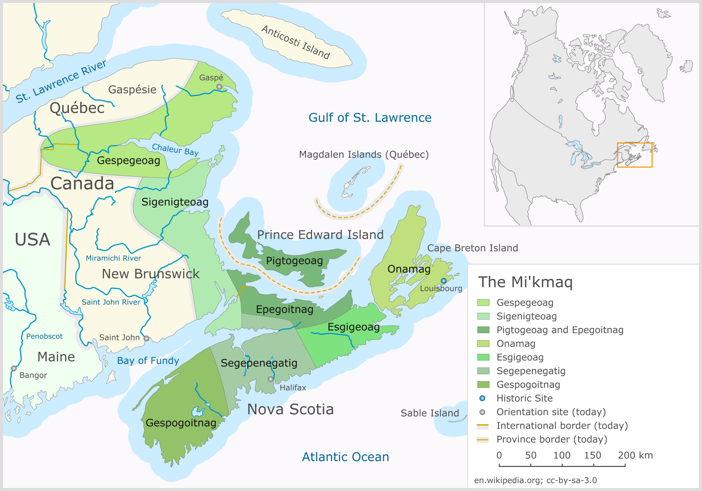
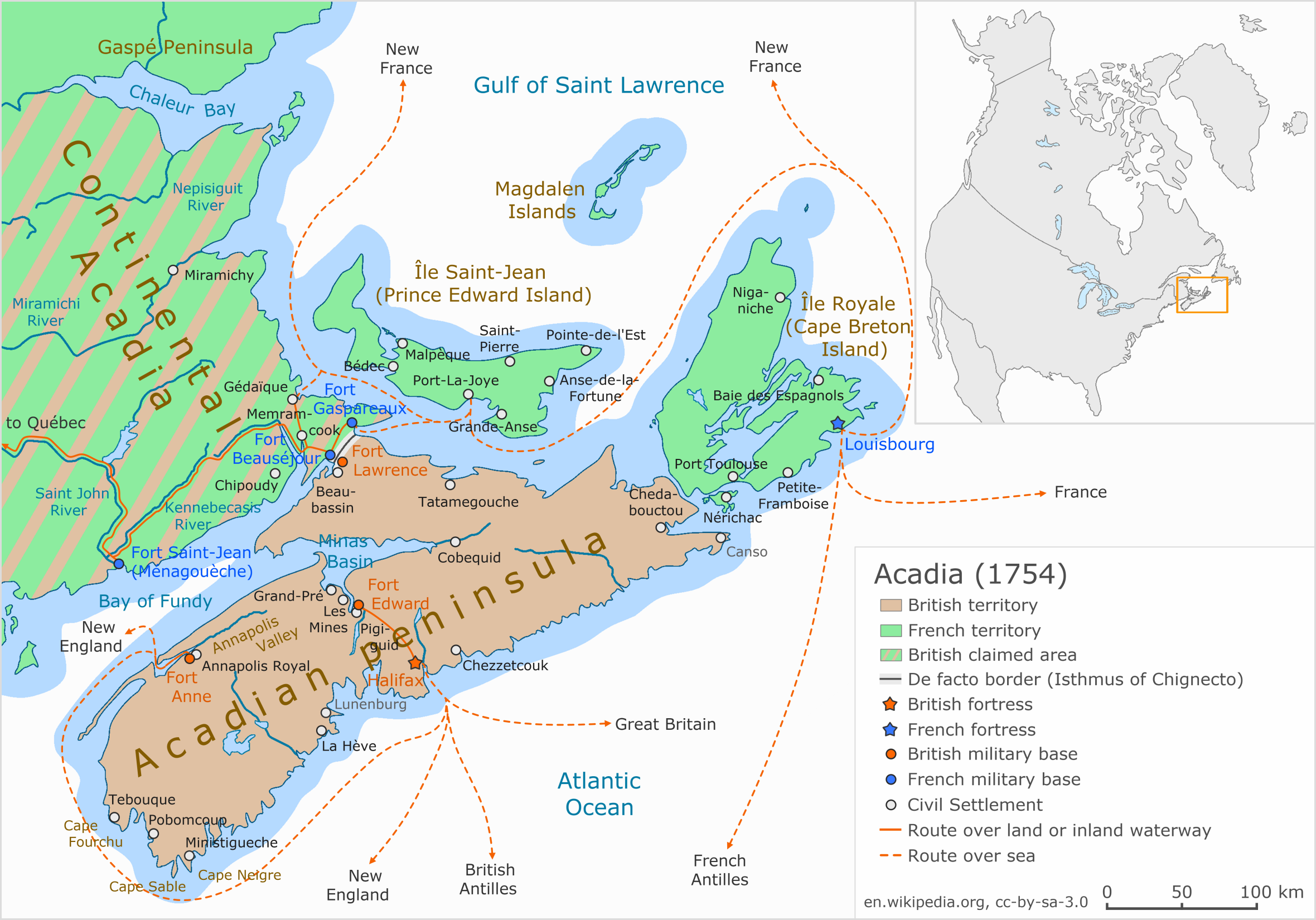
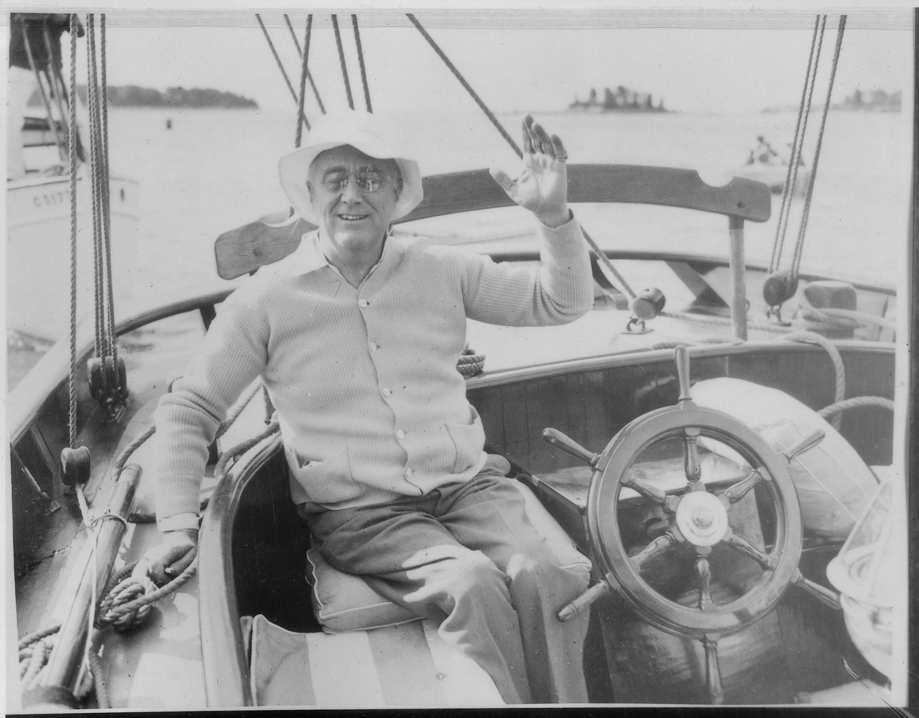
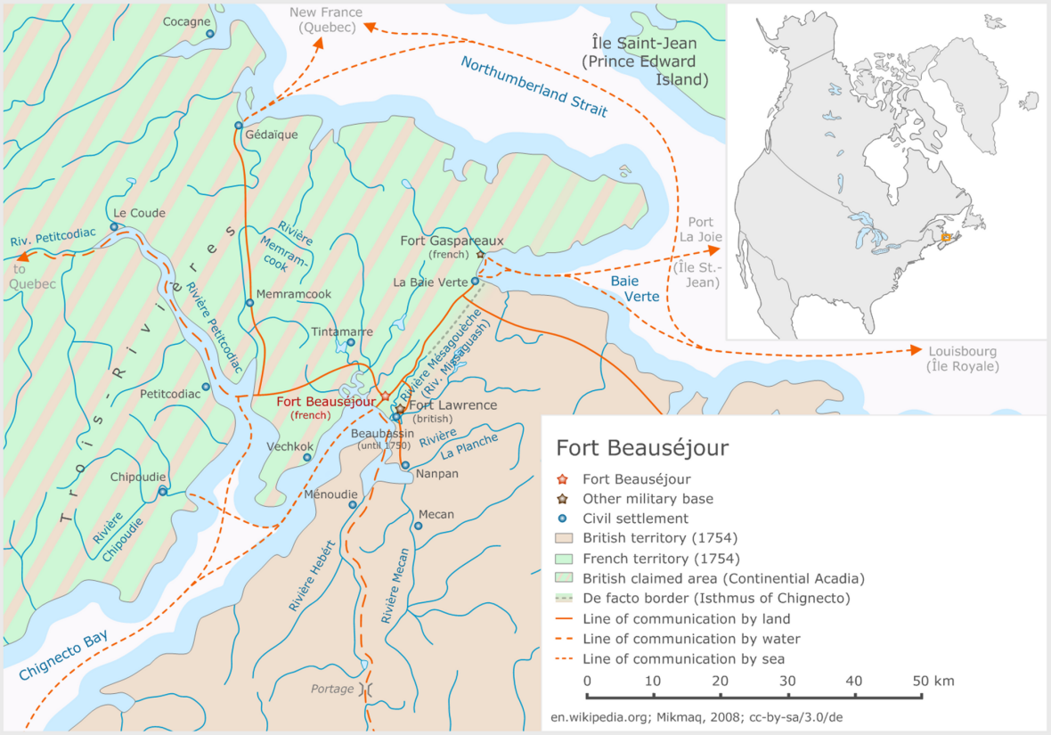
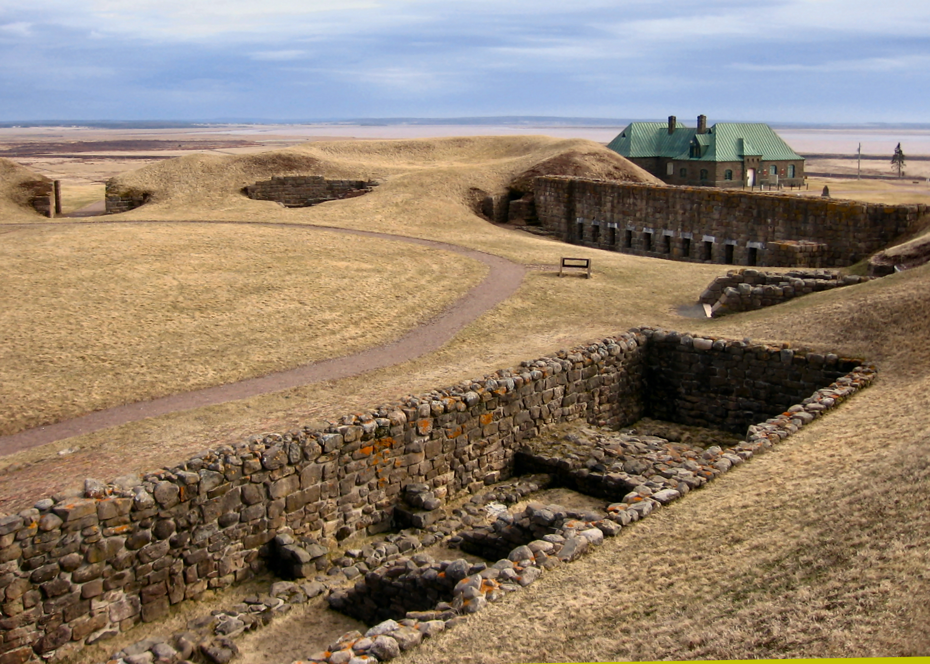
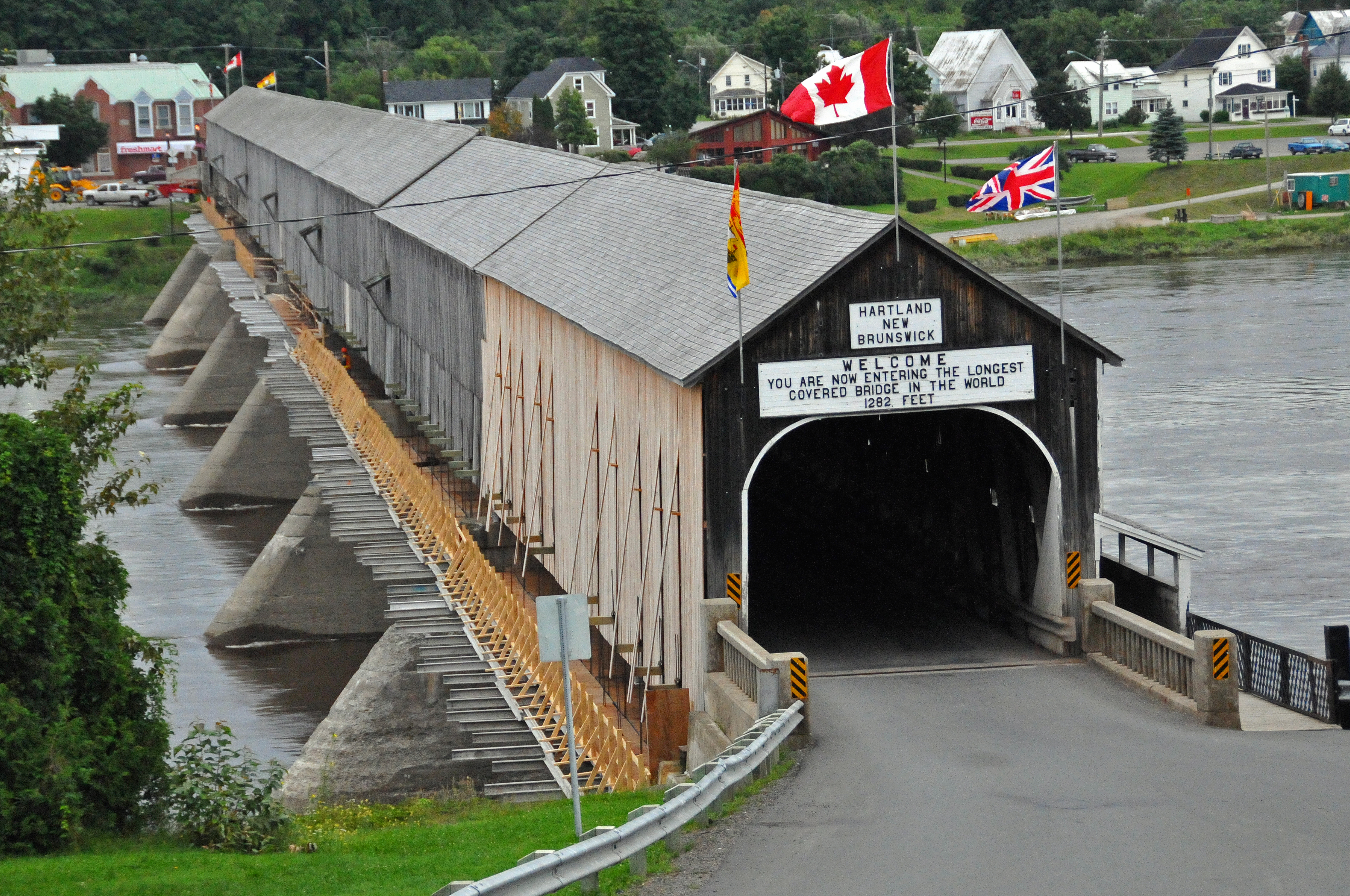
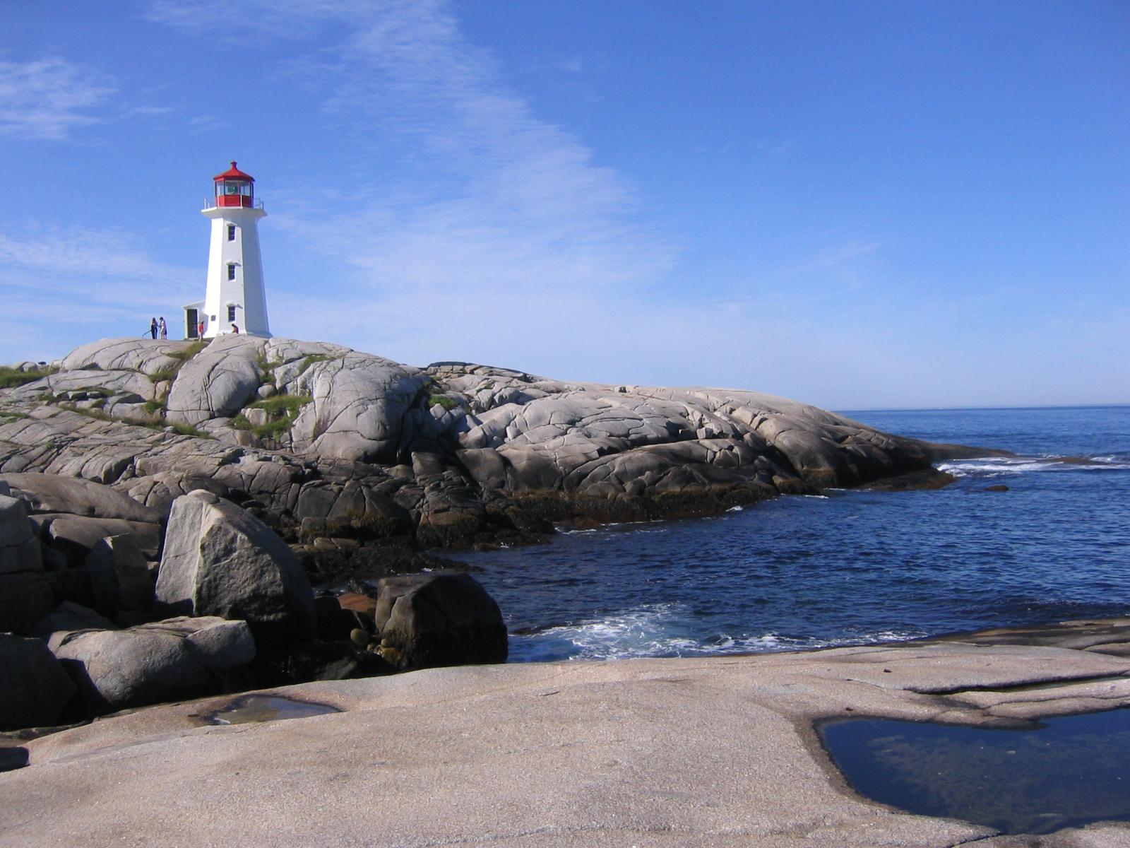