|
Reflections 2011
Series 24
October 4
New England Thrice-3B: Borderlands (QC versus VT, NH, ME, NY)
| | Borderlands The first posting of this third New England trip covered the visit to Middlebury at its beginning and end, but skipped the middle, where I went north into Canada, and along the four states bordering Québec. We’ll discuss this “side trip” to these “borderlands” in this posting. | | | | After two nights at Middlebury Inn, and lacking any rail line (or even bus route) to the north, any more as there had been one coming up from Rutland, I’d once again booked Middlebury Transit for the hour’s ride to Burlington Airport to pick up my car rental. The irony of taking a limo to rent a car strikes me as odd, too, but let’s not go there--I didn’t have any real choice. I was headed to Sherbrooke QC, and from Burlington I went via Saint Albans to a border crossing at Richford, which had some traffic, but wasn’t too busy. Across the border I was in the Eastern Townships, called in French Cantons de l’Est, or more frequently, l’Estrie, based on their location east of Montréal. The French Estrie, based on Est, could correspond in English to a (nonexistent) Eastria, based on East. | | | | I passed through the formerly loyalist town of Sutton, and went up to the autoroute that took me past Eastman, Magog at the head of lake Memphremagog, to Sherbrooke. I say this in such detail in order to show this map. I’d shown the map of the former Central Vermont Railway in the last posting, and now want to show an 1898 map of the Boston & Maine Railroad (click to enlarge) whose routes affected both Canada and the US. | | | | My purpose in showing this map is that, at the time, using either this railroad (routes in red) or others (routes in black), I could have come up from Rutland, via Middlebury (not named), Burlington, Saint Albans, crossed at Richford, passed Sutton, Eastman, Magog, to Sherbrooke. Note that from Saint Albans I could have also connected to Rouses Point NY, which I drove to later; and also via Richford to Newport VT (look how the route crosses and recrosses the border!), where I stayed later. From Newport I’d have had several choices to go north. I could have taken the international rail ferry the length of Lake Memphemagog to Magog (international connections don’t run anymore, there are just pleasure boats who stay on their own side). I could have taken a train along the length of Lake Massawippi to North Hatley, where I also stayed, and to Sherbrooke. There was also a cross-border connection on that line to Stanstead QC and Derby Line VT, both of which I also visited by car. Today, all passenger services here are long gone. Some routes still carry freight to some extent, and others are now grassy recreational trails. It’s all lost infrastructure. Rent a car; that is, if you can find a town large enough to have a car rental service, of which there are very few. | | | | The Eastern Townships The border between Canada and the US is long; we’re limiting our discussion to the border between Québec and New England. In 2011/17 we discussed the loyalists that moved from what was becoming the US to what would become Canada. One description could be that they were eligible, but unwilling Americans, who, in choosing to remain British, eventually became Canadian (that is, their descendants did). We discussed how so many went to the Maritimes, causing New Brunswick to be separated from Nova Scotia, or otherwise to Ontario. These areas became anglophone, except for the strong francophone influence in northern and eastern NB. But the fourth destination was francophone Québec, where they presumably thought they could assert a strong anglophone influence. Perhaps they did in earlier years, although in modern times, that has dissipated under strong francophone pressure. Those that settled in Québec largely populated the farmlands of the Eastern Townships just beyond Vermont (and to a minor extent, just beyond NH and ME). They also later were a strong factor in Montréal. So how did this come about? | | | | Missisquoi Bay is the northernmost part of Lake Champlain. While the southern half of the Bay is in the US, its northern half is the only part of the lake proper that’s in Canada. It was in this part of Québec that the early loyalists settled, during and right after the American Revolution, into the 1780’s. This was well west of what became the Eastern Townships, which weren’t opened to settlement until 1791. The British governor of Québec expected them to move westward into Ontario with the rest of the loyalists in this region, and even cut off the rations the government was providing them to urge them on. But they resisted, and the succeeding governor allowed them to stay. This area is now considered part of the Eastern Townships after all. | | | | The Constitutional Act of 1791 of the British Parliament sought to speak to the situation of some 10,000 loyalists among some 145,000 French speakers in what was a large-sized Greater Québec. It was the law that divided that Québec into two areas, Upper Canada (later southern contemporary Ontario) and Lower Canada (later southern contemporary Québec). Incidentally, it was this law that is seen as planting the seeds of Québec nationalism, since it gave francophones a province of their own. But under the terms of this Act, the Eastern Townships were open to settlement, and a land rush followed, with most of the 3,000 settlers coming from the US. It’s a popular misconception that the Eastern Townships had a huge influx of loyalists. Some were, but most simply wanted land, and didn’t care which side of the international border it was on. Others immigrated from the British isles. Actually, most of the immigration from New England happened in the early 19C, some three decades after the Revolution, and involved farmers who wanted land, which was in plentiful supply in the Eastern Townships. After 1850, francophones started moving in to the area. Anglophones remained a majority in the Townships until the 1870’s. The area is now francophone, but the influence of the New Englanders and Loyalists can be seen in the towns and in place names and street names, to be discussed later. | | | | I mentioned earlier that, right after crossing the border into Canada and Québec, I went through the town of Sutton, a very anglophone name. The first recorded loyalists arrived in Sutton in 1799. From the statistics I’ve found, Sutton today is 2/3 francophone and 1/3 anglophone. | | | | Sherbrooke My first destination was Sherbrooke, the sixth-largest city in Québec Province. It was settled in 1793 by loyalists, including Gilbert Hyatt, a farmer from Schenectady NY, who built a flour mill in 1802, and the settlement was then called Hyatt’s Mills. In 1818, it was renamed Sherbrooke after a retiring Governor General, so both its names have been quite anglophone. Still, today 89.9% of the residents speak French only, and 5.7% speak English only. The city is pleasant enough, but not all that exciting. So why did I rush up there? To take a train ride on a dinner train called the Orford Express (Mount Orford is near Magog). It was an ill-starred venture from the start. | | | | The best train rides fulfill their actual purpose by really taking you to a destination, such as from New York to Rutland. Historic ones are enjoyable as artifacts, and I’ve had my share, including the Cumbres & Toltec and Durango & Silverton (both 2007/14), the Kuranda Scenic Railway (2010/20) and Puffing Billy (2010/23). I’ve only had meals on historic trains in connection with the magnificent British Pullmans, which, although they also do trips to nowhere, when I used them actually brought you to a destination, such as from Victoria Station to Folkstone, to later connect with the Orient Express (2002/2), or from Victoria to the Cunard pier in Southampton (2002/6). The pleasure involved is threefold: in the ride itself; where a meal is involved, in dining; and in meeting people to converse with. With the Orford Express, two out of three isn’t really bad, but . . . | | | | When I found out there was a dinner train out of Sherbrooke, the only time it fit into my schedule was that first day, on arrival into Canada, which is why I got an early start to be there in time. It was the ride that I was really interested in, given the lack of any remaining passenger trains in the entire region. Riding on these Canadian tracks gave the feeling like you were beating the system, which pleased me. The 3 ½-hour round-trip ride left from the former Sherbrooke Station, which today houses a farmers’ market. Look again at the previous map to check the rail route, the lake, and the towns. We went west from Sherbrooke via Magog to Eastman, then reversed direction and returned to Sherbrooke, but this time making the only stretch-your-legs stop of the trip at the former Magog station (I understand it’s supposed to be MAY.gog in English and ma.GOG in French, but I prefer the latter pronunciation). Magog is right at the northern point of Lake Memphremagog, or Lac Memphrémagog, and the station is right on the water, in a park area. One can stroll out on a pier jutting out into the lake and climb a wooden viewing tower at its end, which can be seen, in gray, by clicking to enlarge the above picture. Lake cruises leave from the pier, but it certainly seems that, at one time, this was an intermodal station connecting with lake ferries to the opposite end of the lake, in Newport, Vermont--but this is only speculation. Since you are from here looking down the length of a very long lake, the lake view is outstanding, and even better from the tower. | | | | The lake is glacial in origin, and is 43 km (27 mi) long. 73% of its surface is in Québec, but ¾ of its watershed is in Vermont, which indicates that it’s north-flowing, draining in Magog into the Magog River. Magog was founded in 1776 (!!!) by loyalists from nearby Vermont. At first, they called the town The Outlet, referring to the flow of lake water into the river. | | | | I suspect the main attraction for most of the passengers was the food, since they seemed to be largely locals going out to dine on a weekend afternoon. The three cars of the train were not overly historical, but were very nicely mid-20C cars done as luxurious dining cars. The middle one had an upper-level viewing area, which is where I managed to book a seat. The food was quite good, although nowhere like the British Pullmans.
| | | | So what was wrong with all this? Being totally ignored. In train dining cars people sit together family-style, and I was at a table for four with an older couple and one of their mothers. I expected to hear French, not standard European French, but Québec French, which takes a lot of getting used to (I haven’t succeeded yet). I tried making a few pleasantries in French, but got no answer. They didn’t talk too much with each other, but when they did, it’s as though I wasn’t there. The ride was nice enough, the food was good enough, but it was boring just sitting there for 3 ½ hours, being ignored. | | | | Le Québecois Four languages came from Europe to the Americas. Spanish varies between the two, mostly in pronunciation, but not so much as to make it incomprehensible. I doubt that the difference between British and American English causes huge amounts of trouble to non-anglophones. I don’t speak Portuguese that well, but what I know is European, and I’m aware that there are larger differences between that and Brazilian Portuguese than I see in the others. But I get the feeling the differences are greatest between standard European French and Québec French, or Québecois. Most people I know who do speak French also find it a barrier. Not knowing a language when you get to a country is one thing, but knowing the language and still not understanding is something else. It’s frustrating in Québec. The written form is no problem--the rail website sent me the occasional email in French, I responded in French with no trouble. It’s just spoken Québecois that’s so difficult. | | | | Not planning on taking any courses in (Québec) French at, for instance, McGill, I decided to do some investigating. There are three areas of language. The technical terms are lexicon, syntax, and phonology, but the everyday terms are vocabulary, grammar, and pronunciation. | | | | I don’t suspect huge problems in the lexicon/vocabulary, nothing beyond the differences in British and American English. For bicycle, Standard French vélo is in Québec French bicyclette; for shopping, SF les courses is in QF le magasinage. I just learned both words for snowplow, and both are fun. In SF it’s chasse-neige (“snowchaser”), but in QF it’s souffleuse (“whisperer”), while a chasse-neige is instead a snowplow. | | | | Syntax/grammar variations can be trickier to understand, but also harder to explain here easily. I understand QF uses the familiar tu a lot more frequently. The word moi, (pronounced MWA) appears as moé. Plural can be conditioned by meaning. Monde, used to mean “people” is nevertheless singular in SF: Beaucoup de monde est ici, but can easily appear in QF with a plural verb: Beaucoup de monde sont ici. “I go” in SF is je vais, in QF je vas. I’ve read about numerous other variations, but they’re hard to explain to non-francophones. | | | | It should not surprise, though, that the biggest block to comprehension is phonology/pronunciation. I will mention just two variations I’ve read about. T becomes TS before I or U. That would mean, that SF tigre would be pronounced TSIGR and tube TSÜB. Correspondingly, D becomes DZ in the same positions: so dis would be dZI and duc would be DZÜK. I suppose then that dis-moi would become dis-moé DZIMOÉ. | | | | Another pronunciation change is technically called replacing tense vowels with their lax equivalents under certain circumstances, but an illustration should show what that means: police would be pronounced po.LISS and praline would be pra.LINN. Or, the word for “chicken”, poule, which in SF sounds like “pool” in QF sounds like “pull”. I’m am only hypothesizing these pronunciations from what I’ve read, and all the above is certainly learnable, but barring study of QF--or living there for a while--I think this shows the difficulties involved. | | | | North Hatley & Lake Massawippi After the train excursion, I drove down from Sherbrooke to North Hatley, which my hotel, Hovey Manor, was adjacent to. Tiny North Hatley has to be one of the most charming little villages in Canada. I visited it quickly that day, mostly by car, came back the next day (the stormy Sunday) to wander about under an umbrella, and stopped again to do more walking as I was leaving on Monday. | | | | The historical marker in the town says it was first settled by loyalists in 1792, mostly from nearby New Hampshire and Vermont, among them landowner Ebeneezer Hovey, that the hotel, Hovey Manor, is named after. North Hatley (as well as nearby Hatley) is named after a village in England, which I now find is southwest of Cambridge. Very interesting was the next marker, that talked about the nearby Chemin des Cantons; Patrimoine américaine et britannique which, given the subject matter, did have in smaller writing below “Township Trail; American and British Heritage”. The map shows it’s a circular connection of various roads through the Eastern Townships totaling 415 km (260 mi), that included Sutton and many other towns, but only came near North Hatley, which was referred to as an Étape hors-route, an “Off-Road Stop”. | | | | But it was the construction in 1880 of a rail line that made North Hatley a popular summer resort destination, and the town owes much of its grand houses to those first, rather aristocratic, summer people. Many of them were from the American South, and for some time after the American Civil War (1861-1865), many wealthy Southerners renounced New England (Yankeeland) as a summer retreat and continued further north into Canada, some by private railway car. Rumor has it that many drew their blinds in passing through Yankee New England.
| | | | As Magog is at the outlet to its lake, North Hatley (in red, with township borders) is at the outlet of the smaller, but still considerable, Lake (Lac) Massawippi (click to enlarge; note pavilion at left), where the waters flow north into the Massawippi River (Rivière Massawippi). At the waterfront park the most striking thing is a beautifully decorated (with flowers on the railings when I was there) wooden walkway with a pavilion at the end (as in the previous picture). It almost connects both sides of the mouth of the river (a roadway, just to the left, does connect them), except it stops at the pavilion, leaving a gap on the far side. It’s so attractive, in nice weather, even in the rain, that I wondered what it had been. It might be referred to as a pier, except nothing could dock at it, and there was a pleasure-boat marina anyway beyond the roadway in the river. Then I suddenly had an epiphany. Of course! It was a disused and recycled, one-track railroad trestle over the river’s mouth, from the days vacationers would come to North Hatley--and Hovey Manor--by train, as in our earlier map! | | | | North Hatley is one of the few primarily anglophone enclaves in Québec. The statistic I found is that it’s 60% anglophone, and is known for its active bilingualism. While I heard French when I walked through the local market, on the street I heard two women speaking English, which struck me as pleasingly offbeat, being in such an otherwise francophone atmosphere. | | | | Signage & Hybrid Signs I also drove past Saint Barnabas Anglican Church in North Hatley, whose sign was, oddly, entirely in English, as just indicated. I bring this out in order to discuss two things, the Frenchification of Québec signs, and some very curious hybrids. Some years ago, when Québec decided its only official language was to be French, it was declared that all public signs had to have at least a French framework. The current phrasing is that French should be “markedly predominant”. All red, octangular signs that used to say STOP now say ARRÊT. Yellow vehicles marked elsewhere in Canada and the US as SCHOOL BUS are now marked in QC ÉCOLIERS (“schoolchildren”). Note the writing on the side of the bus: “AUTOBUS Robert Paquette & Fils Inc”. That perhaps might have once read “BUSES Robert Paquette & Son(s) Inc”. Hovey Manor now appears as Manoir Hovey. | | | | Signs with street names were also affected, and this tended to have a peculiar affect on anglophone enclaves that had otherwise had street names and signs in English. I’ll use North Hatley streets as an example. Sherbrooke Street is now Rue Sherbrooke and Magog Road is now Chemin Magog. What apparently was once Merrill Park Boulevard is now Boulevard du Parc Merrill. Note in particular that this last one is fully translated into French. | | | | The peculiar affect I refer to, though, is shown by present North Hatley street names like Rue School and Rue Mill, and not as one would expect, Rue de l’École and Rue du Moulin. I can only speculate that these anomalies might have arisen due to local anglophone objection to too much Frenchification, but I don’t know that. Other than on maps when I was preparing the trip, I first came across this phenomenon when I was outside of Sutton on arrival two days earlier, and drove along Rue Stagecoach (not Rue de la Diligence). I saw more of it later (see below) when in Stanstead and found Rue Church and Rue Railroad (even with the railroad gone) instead of Rue de l’Église and Rue du Chemin de fer. The oddest one of these without a doubt involves the North American proclivity for calling a town’s main street Main Street. In Magog, the main street is Rue Principale, which certainly looks like a translation from English. But in North Hatley the main street is Rue Main. This HAS to bring a smile to one’s face when one realizes that main is otherwise the French word for “hand”. | | | | This is a YouTube video of North Hatley: | | | | | | 0:50 - Rue Main crossing the river.
0:53 - The view from the river out to the lake, including the Rue Main bridge, and BEHIND IT, the wooden walkway coming from the right and ending at the pavilion. Note the flowers on both locations.
1:10 - The flower-bedecked wooden walkway.
1:55 - The marina in the river. Don’t bother watching after 2:25.
|
| | | | Hovey Manor / Manoir Hovey Just a few minutes from Rue Main along Chemin Magog on the north shore of the lake, then branching onto Rue Hovey, is le Manoir Hovey, which calls itself a country inn, but is a very pleasant hotel. The building was the home of one of the Southerners who arrived in North Hatley late in the 19C. The extensive house was built in 1900 by a Henry Atkinson from Atlanta, Georgia, which he named The Birches. He wanted it to be in the southern tradition, so the façade that faces the lake has a broad porch with thick, tall, white pillars, supposedly modeled after George Washington’s Virginia home, Mount Vernon. The Manor, an inn since 1950, was named in 2007 one of Canada’s top ten hotels, the only one in the east. It is also a member of Relais & Châteaux, the first I’ve stayed at. Relais & Châteaux is a global grouping of individually-owned and operated luxury hotels and restaurants, with about 500 members in 60 countries on five continents. It has strict admission standards, and inspects properties regularly. Most member hotels are manor houses, townhouses, or castles in attractive settings. They are evaluated by the “5 C” motto: Caractère, Courtoisie, Calme, Charme et Cuisine. | | | | I’d pictured the hotel in an open area, but it was quite narrow and long and had its back almost to the slope, with only a narrow road running the length of the hotel, with one row of parking on the side. The hotel reminded me of someone on a cliff, spreading their arms out along the rockface behind them, trying not to fall forward. Actually, this added to its secluded charm to me. In front of the building there was, although also narrow, a garden and sitting area, and stairs down to the dock area for sunning, boating, and swimming. The building reminded me of a lodge. I enjoyed the garden on arrival and departure, but the central day was the stormy Sunday. I was delighted to be able to sit with my laptop in the library, in front of a roaring fire. There was another fire in the room outside the dining room. It was a very cozy stay. Although strongly promotional in nature, this video of Hovey Manor shows the garden, the lake, and the interior. | | | | The North Woods Even its name enchants as a place of mystery and solitude. There is a huge west-east forest that straddles the border. It lies mostly in Canada, but enters the US at either end. The western end wraps around the upper portion of the Great Lakes and runs along the Saint Lawrence River Valley to and eastern end beyond Québec City and in northern New England. Its technical name takes the river’s name: the Laurentian Mixed Forest / la Forêt mixte laurentienne, but its everyday name is the North Woods. It’s called “mixed” because it’s a transition zone between the boreal (northern) forests further north and the more temporate forests further south, and has characteristics of each: conifers such as pines, spruces, and firs, and deciduous trees such as aspens, oaks, paper birches, mountain ash, and maples. | | | | I haven’t found a map of the entire forest, nor have I gotten any maps of it on the Canadian side. I do have a map of the western end of the North Woods covering northern Minnesota, Wisconsin, and Michigan, and one will have to picture it then continuing on this map across Ontario and then into Québec and up the river valley. However, I do have pictures of the three northern New England states it reaches into and we can see where the North Woods are in a rather unusual way--via low population density. Where there are fewest people is where we have the North Woods. | | | | This shows the population density of Vermont. As we’ve discussed before, the population is concentrated around Burlington in the NW, and going S, you can judge where Middlebury, Rutland, and Bennington are. To the N is Saint Albans, but move NE of that. You see Lake Memphremagog where it juts in from Québec, with Newport at its southern end. But then note the very low population (dark green and two lighter green areas below it) of Essex County in the NE corner of Vermont. It’s population last year was 6300, making it the least populous county in both Vermont and in all of New England. Essex and two other counties comprise what is called in Vermont The Northeast Kingdom (NEK) or just The Kingdom (as in the shop sign I saw in one of the towns, something like “Kingdom Hardware”). As of 1997, 80% of the Northeast Kingdom was covered by forest. Of that, 59% was northern hardwood and 29% spruce or fir. There is also a Kingdom State Forest. The NEK is roughly the extent of the North Woods as they reach into Vermont. The NEK has been listed in “1,000 Places to See Before You Die”. In 2006, the National Geographic Society named the NEK as the most desirable place to visit in the US and the ninth most desirable in the world. I think that’s gilding the lily quite a bit, but it is a nice place. This is a NEK road and this is a NEK mountain panorama (click to enlarge). | | | | Moving directly east into New Hampshire, we come to that large county (down to the black line) filling the entire northern panhandle, Coös County (KO.us). Coös is the largest in area in NH, but has the smallest population. Much of it is national forest, state forest, or wilderness. Directly east of that is northern Maine. Much of the northern part of Maine is forested, as can be seen by the low populations. Rangeley and Rangeley Lake are in Franklin County, the second one in from the NW corner, after Oxford County, both of which are in the second-from-darkest green color. The area is heavily forested. | | | | The US/Canadian Border There are eight Canadian provinces that border the US. I just checked the travel diaries to confirm one doubt (yes we did cross between Glacier NP, Montana and Waterton Lakes NP, Alberta in 1968), so now I can confidently say that I’ve crossed the border to or from every province, from northern British Columbia (coming from Alaska, driving to the Yukon) to New Brunswick, except Saskatchewan. (So what am I waiting for?) In addition, I’ve also taken the overnight ferry from Maine to Nova Scotia, so I entered Canada there, too. | | | | It’s trickier on the US side. There are technically thirteen states bordering Canada. For states with counties sharing a land border with Canada, those counties are shown in green, while counties with a water border (river or lake) are in blue. However, Ohio’s and Pennsylvania’s water borders with Ontario run down the middle of Lake Erie and there are no border crossings, so we have to recalculate: you can cross the Canadian border to or from eleven states. I again checked the travel diaries to confirm one doubt (yes we did cross between Sault Sainte Marie, Michigan and Sault Sainte Marie, Ontario in 1983), so now, quite to my surprise, I can say I’ve crossed the border to or from every state between Alaska and Maine, except Idaho. Since the northern end of Idaho is a skinny panhandle, I checked, and find there’s only one Idaho county on the border. And it’s hard to accept the irony that it’s actually named Border County. | | | | North Woods: New Hampshire But before this August, I would have had to have listed both Idaho and New Hampshire as places where I hadn’t crossed. I’d decided early on, though, to cross the border at NH this trip because I knew I’d done other crossings in New England and that narrow panhandle of NH was just tempting. Reducing the list, a list I didn’t realize was there, down from two to one, just Idaho, is now a surprise bonus. | | | | I left North Hatley and headed east for the hour-and-a-quarter drive to the border town of Chartierville, which is almost due south of Québec City. Away from the more built-up lake area, I entered more deeply into the North Woods, with fewer towns. I have a distinct memory of coming down a slope and looking ahead down an arrow-straight section of Route 210, with forest on both sides, and seeing the road go on forever, except that it looked different up ahead. Sure enough, soon it suddenly turned into a dirt road, as though to tell me that we’re really far away from anyone. That lasted for 20-30 minutes until I got to tiny Chartierville and turned south onto a slightly more main road--it was paved--coming from Québec City to the border a couple of minutes away. | | | | The New Hampshire panhandle being as slender as it is, this was the only road entering NH, and so the only international border crossing NH has, which I thought was another fun thing. [I see now that Idaho has two roads and two crossings, and that the NH border is actually longer, at 93 km (58 mi), than Idaho’s at 72 km (45 mi). They are the states with the shortest borders that have crossings, although Pennsylvania’s water border in the middle of Lake Erie is technically the smallest at 68 km (42 mi).] | | | | The crossing was at the top of a hill, with a nice forested view back down into Québec. There must have been a change of watershed, since I knew the lakes on the US side flowed south. I stopped just past the Canadian station to look at the waist-high stone stele designating the border, and enjoyed walking around it in a circle, changing countries as I did. I think that was the first time I’d done that, although I ended up doing it again the next day in Derby Line (see below). And then it was time for another fun session of baiting a border guard, so I pulled the car up to the guard’s booth. | | | | I don’t really do it intentionally, but it might yet develop into a hobby. Especially in recent years, US border guards, instead of welcoming people to the US, have developed a dour mien, have been apparently taught not to fraternize, and to say things just so, and to elicit responses said just so. For instance, five years ago (2006/12), when I was staying at the Mount Washington Hotel in Bretton Woods NH, I did that long day trip with a drive through the Eastern Townships to Middlebury and back. I drove up I-91, crossed at the large customs station in Derby Line, drove for maybe two hours in Canada, through Magog, a then reentered the US at I-89 north of Saint Albans. The US border guard asked me where I was coming from. Being totally truthful, I said Bretton Woods NH. That didn’t sit well with him. Where in Canada was I coming from. I didn’t go anywhere in Canada, I just drove through. We weren’t getting anywhere, so I lied and said I was coming from Magog. That satisfied the precise way of thinking he’d been taught, and we were done. | | | | So I wondered what song-and-dance we’d have this time. Why had I gone to Canada. I wanted to see Canada. (That’s the absolute truth, since it wasn’t a business trip, and I wasn’t vacationing, I was just traveling to and through Canada.) But the truth didn’t fit the mindset he’d been taught, so we continued our repartee. He wouldn’t give me a choice of words, although I of course knew what he wanted; business or pleasure. Business implies meetings, pleasure implies to me swimming pools. This trip was neither. But of course, they always win, so I lied and said “pleasure”. This is the manner in which our borders are guarded. He was what we call in German a Beamter, which is like a “government official” or “civil servant”, a person whose mentality involves pigeon-hole thinking. | | | | Between walking around the stele and continuing to talk to him, I might have been at the crossing station 10-12 minutes, and not a single vehicle crossed in either direction while I was there, and there were precious few on the roads before and after. We were, after all, at a remote crossing in the North Woods. So I decided anyway to get chatty. He lightened up, and asked me, this time just to make talk, why, if I was from New York, I was crossing here, and the answer was again like the “wanted to see Canada” answer: I just wanted to cross here, for the fun of it. I asked him who it is that does usually cross here, and not surprisingly, their contacts involve almost exclusively people from lower NH, the populous part, who want to go to Québec City, and vice versa. That’s about it. I wonder if my “just want to travel around” attitude stuck in his mind to any extent as he ponders his hours of watching mostly empty roads ahead and behind. | | | | This northern third of NH is referred to locally as the “north country” or “north of the notches”, referring to the local word for mountain pass. It contains less than 5% of the state’s population, and is losing population as the logging and paper industries decline, but those industries do reflect the fact that we’re in the North Woods. The atmosphere on both sides of US 3 as I drove along was overwhelmingly woodsy. That’s somewhat due to the fact that there are national and state forests here, but even further along, in an area of more population and resorts, the woods surrounded you. More than once, signs along the road referred to the area as the “Great North Woods Region”, and, significantly, on this side of the border, “(Région des) Grands Bois du Nord”. There were also a number of signs that warned breathlessly “Brake for Moose . . . Hundreds of Collisions!” I didn’t see any, since, like deer, there’s out after dawn and during twilight, but I’ve already confronted a huge moose in the road ahead when we were driving in Cape Spear, Newfoundland, early one Sunday morning years ago. | | | | It’s hard to get maps of this area that show the detail I want, so we’ll look again at that older railroad map. Look to the right of Sherbrooke where I drove into the top of NH. This map shows all four Connecticut Lakes (their names are numbers), where many maps only show the two larger ones. Then find the Vermont border town of Beecher Falls, almost impossibly squeezed in to the Canadian border on its north side and the New Hampshire border at the Connecticut River on its south side. I also stopped in Colebrook, which showed some French influence. Finally look right to the Rangeley Lakes and the town of Rangeley, where I stayed. Although it did once have (narrow-gauge) rail service as well, it connected in the other direction, and one could have only connected with Vermont in a roundabout way--but it still was possible. | | | | CONNECTICUT LAKES The Connecticut Lakes, the source of the Connecticut River, have always intrigued me because of their remoteness, which, as we now know, is because of the North Woods. There are four, each increasing considerably in size, which is why usually only the two largest southernmost ones appear on maps. Their names are also rather unique, since they are simply numbered. They are all in New Hampshire above the 45°N parallel, in that part of NH that extends beyond (further north than) the Vermont/Quebec border. | | | | Coming over the Canadian border, the tiny Fourth Connecticut Lake is up in the hills to the west. It’s technically the actual source of the Connecticut river, which later divides Vermont and New Hampshire, and then continues down the middle of Massachusetts and Connecticut, emptying into Long Island Sound. The Fourth Connecticut Lake’s elevation is 810 m (2670 ft) and is only 0.73 hectares (1.8 acres). Rating the last and largest lake, the First Connecticut Lake, as 100%, the Fourth is merely 0.06% of its size. The only way to reach the Fourth is by a difficult mountain trail that crisscrosses the international border, since the lake is only 1 km (0.6 mi) from it. It’s one of the few international trails in North America, but no passport is needed, since the beginning and end of the trail are both in the US. I presume the path to it is at or near the customs station; I didn’t see it, but didn’t plan on hiking through the woods to see it, anyway. I’ll still consider I’ve been at the source of the river. | | | | [I can only think of two other rivers I’ve been at the source of. Minnesotans like to visit Itasca State Park, where, emptying out of Lake Itasca is a bubbling brook, with stepping stones across it, that is the Mississippi. Also, when in northern Spain, we drove into the mountains to see the Nacimiento del Ebro, the Source (“Birth”) of the Ebro (River), a major river of Spain that flows SE into the Mediterranean. Since the earlier Latin version of Ebro was Iber, many believe the entire Iberian Peninsula was named after this river. Finally, before we met, Beverly visited Donaueschingen in SW Germany, the source of the Donau/Danube, but I never did.] | | | | The first lake the driver encounters just south of the border is the Third Connecticut Lake, also to the west. Its elevation is already down to 667 m (2188 ft), and its size is 93 ha (231 ac), or 7.5% the size of the First. | | | | The remaining two lakes are to the east of the road, and shortly one reaches the Second Connecticut Lake at 569 m (1866 ft). It’s 400 ha (1102 ac), making it 36% the size of the First, which follows in just a while at 499 m (1638 ft) and covers 1228 ha (3071 ac). From this point, the river remains for a while just in NH, but then begins to divide it from Vermont. | | | | BEECHER FALLS & COLEBROOK The straight line dividing VT and QC extends to the Connecticut River, but it joins the river just a bit after penetrating into NH. This leaves a sliver of VT projecting into NH, with NH territory both north and south of VT, and allows for an unusual pair of borders. Proceeding down US 3, I saw a turnoff to the right (north). This allowed me to (1) cross the Connecticut River, by now gaining some size, on the first interstate bridge over it. It got me into (2) Beecher Falls VT, a tiny town in the sliver, and within 30 seconds of entering the town from NH in the south, there was (3) the international crossing from VT to QC at the north end of the town. It’s odd to see a change of borders like this. | | | | A bit further along, I decided to pop over the second interstate bridge over the river, and entered VT a second time. Both these VT pop-ins were in its Northeast Kingdom. Returning to NH, I could enjoy the North Woods and river scenery on both sides. I came to the town of Colebrook NH, where I was to turn east, but even in a quick drive-thru I saw two examples of French influence this side of the border. A sign in a market’s parking lot said Exit/Sortie, and nearby was Le Rendez-vous French Bakery. No big deal, but a bit of influence can be found. | | | | DIXVILLE NOTCH & “THE BALSAMS” At Colebrook I turned east over Dixville Notch to go to Rangeley, Maine. Vermont likes to call its mountain passes “gap” (Middlebury Gap), even though the word otherwise just means a space between two limits, and NH likes to call its passes “notch” (Franconia Notch, Crawford Notch, Pinkham Notch), even though the word normally means a V-cut an ax makes in wood. Up in the North Woods, Dixville Notch is the northernmost of the NH notches, here not very far below the Connecticut Lakes. The state isn’t very wide up in the panhandle, and it wasn’t far to the Notch. There was a spot to pull over where you could look just ahead into the Notch (570 m [1871 ft]), or could look to the left to see The Balsams Grand Resort Hotel. (The reason why the historical marker says “First in the Nation” we’ll discuss in a moment.) The hotel dates from 1866 and lies across Lake Gloriette. It’s one of the Historic Hotels of America and is on the National Register of Historic Places. Since I’d stayed at the similar Mount Washington Hotel five years earlier, I decided against staying here and opted for bread-and-breakfasts instead, but this is a beautiful place. You drive around the lake and can easily tour the hotel. The ugly brown addition to the right is still called the New Wing, even though it was added in 1918, but it’s the grand white, wooden structure to the left that’s the glory of the location. It has one Victorian sitting room after another, and wraparound porches in the front that offer a view across the lake of the notch slicing its way through the mountain. | | | | On a wall is posted a list of 28 (!!!) grand, wooden 19C NH hotels in the mountains. I could just imagine people taking the train to Colebrook and being picked up by the hotel. The Balsams, as the oldest, was at the top of the list of the 28, since it’s been in continuous operation since 1866 (summer only; since its centennial in 1966 in the winter as well). The Mount Washington was about 2/3 down the list, since it dated from 1902. But the list was gripping because of the fact that only two others of these 28 still exist. One is now a condominium, and the other is empty. All the other hotels burned to the ground (mostly) or otherwise, were razed. Sic transit. | | | | BALLOT ROOM So what was the reference on the historic marker about “First in the Nation”? The Notch? The Hotel? Neither. The village of Dixville Notch is the first jurisdiction in the US to cast, count, and report voting results in presidential elections, as well as in NH primaries, and it does so right after midnight. And therein lies a tale. | | | | I’d thought it had been going on forever, but it started only in 1960. The village of Dixville Notch takes advantage of a NH law that allows a precinct to close early if all registered voters in that precinct have voted. As it turns out, the polling place is located in The Balsams, in a room actually called the Ballot Room. Since the village has a population of only about 75, all registered voters gather before midnight, and are counted to make sure everyone’s there before balloting takes place. Although it was set up as a lecture room when I was there, I understand the room features separate voting booths for each citizen. Voters cast their ballots at midnight, and the polls officially close one minute later. The results are then broadcast statewide and nationwide right afterward, and even get international media attention.
| | | | The Ballot Room is a smallish, beautifully wood-paneled room. The official Ballot Box is set into a niche under glass on one wall. One can spend a lot of time looking at the many, many photographs and documents filling the walls of every politician, winners and losers, as well as many entertainers, who visited NH and the Ballot Room in the half-century since 1960. | | | | North Woods: Maine Beyond the Notch it wasn’t too far to the border with Maine, and the drive all the way to Rangeley was completely forested, with only the occasional house and boat dock, given the other lakes besides Rangeley Lake. I did pull off just a bit into a parking area to follow a sign that promised a covered bridge. It was built in 1898, and had a small barrier so vehicles could no longer use it, just pedestrians. I’ve driven over covered bridges before, but this might be a first for walking across. It’s a common misconception that these bridges were built with roofs and sides (partial or complete), simply to protect the roadway from snow. If that were the case, what good would a snowless bridge be if the roads leading to it on either side were impassible with their own snow? The covering has to do with preservation. An unprotected wooden bridge might last only 10-15 years, but covered could last 70-80. This is a typical covered bridge in Vermont. | | | | I had a late afternoon arrival in Rangeley, and right on the quaint, turn-of-the-20C Main Street I found the accommodation I’d booked, the Rangeley Lakes B&B. Sandy runs it, and he explained how he’d renovated a 1920’s house, and added a large deck in the back where his property faces the town’s Lakefront Park, which essentially means that Sandy has a huge back yard on Rangeley Lake, although at the opposite end as this view. I went out to the water’s edge after talking to Sandy and onto a grassy peninsula into the lake to enjoy the late afternoon atmosphere. | | | | I was the only guest that Monday, but over the weekend, during Irene, he’d had a full house because of hikers that had fled the nearby Appalachian Trail (click to enlarge, and move up to Maine at the top. North is towards the upper left). The Trail runs for 3510 km (2181 mi) from Georgia to Maine, and passes near Rangeley over Saddleback Mountain (which has a ski resort), where the Trail crosses the summit at 1255 m (4116 ft). One side of Saddleback drains into Rangeley Lake. On the map, follow the trail to its northern terminus at the highest mountain in Maine, Mount Katahdin 1605 m (5267 ft), shown here rising out of the North Woods. The trail leads up Katahdin to its summit. Good luck to ‘em, it’s not my cup of tea. I observe; I appreciate; I don’t hike. | | | | For dinner that evening I went to the Parkside & Main Restaurant, whose name alone tells you it’s next to the B&B. It’s a converted house that embodies the rugged rusticity of the town, and also had a lake view at sunset. I found something on the menu I’d heard about and wanted to try, especially given that we were in the borderlands region near Canada. It was a nice steak with Montreal steak seasoning, and was outstanding. I then wanted to find out more about it. To do so, we have to go back one step, to Montreal smoked meat. It’s a type of deli meat similar to New York pastrami, and is made by curing and salting beef brisket with spices for a week, which is then smoked and steamed to completion and served on rye bread. I have yet to sample this. | | | | Then in the 1940’s and 1950’s, someone at one Montréal deli got the idea of using these pickling spices instead on steaks and grilled meats, not for pickling, but just for flavoring, and such preparation has now become common in Montréal. The primary spices used in Montreal steak seasoning include garlic, coriander, black pepper, red pepper flakes, dill seed, and salt, although recipes vary. In any case, they make a good steak. | | | | Along with lobster, Maine is known for blueberries, and it produces 25% of all blueberries in North America, making it the largest producer in the world. The season runs through late summer, and Sandy had promised me blueberry pancakes for breakfast (as I recall, I’d had blueberry pie for dessert the night before). With the pancakes, I had Maine maple syrup. It was Sandy who first told me that syrup can also be made from birch trees; it’s sweeter, and also more difficult to process. I spent breakfast time learning about the area from Sandy, who had historical pictures of Rangeley. He retired from a paper mill, but many mills are now closing. | | | | North Woods: Vermont The next day I backtracked from Maine into NH, over Dixville Notch, through Colebrook again and down the Connecticut River for a bit to the next (third) interstate bridge over it and into Vermont’s Northeast Kingdom. Everywhere on and near the river were forlorn rail lines. I reached Island Pond VT, which had been a major railroad hub between Montreal and Portland. In the center of town I passed the former rail station, which is now a bank. Where the parking now is in the back was where the tracks used to be. Click to look at the road signs on the left, which turned out to be prophetic. This was where I took Route 105 to Derby, and a short distance out of town found that a bridge washout because of Irene had closed the road, with no suggestion of a detour. I came back to town and instead took the posted Route 114 to 111, which got me to Derby as well. | | | | Just to the north of Derby, I reached my goal for the day, Derby Line, on the border. For continuing guidance, we’ll look again at that old map that shows the area so well. Note the border location of Derby Line and the former Rock Island; note nearby Stanstead; note how close Newport is at the bottom of the lake, and all the rail lines it still has going through it, and particularly note the west shore of the lake and the international border. | | | | Derby Line Derby Line can act as a symbol for overzealous border protection that’s taken to the extent that it not only inconveniences, but also diminishes the lives of, the people it’s supposed to protect. It does this by splitting their communities in two. | | | | Derby Line VT and the former Rock Island QC (now incorporated into nearby Stanstead QC) face each other across the international border. They have always acted as one community. A short distance to the west, Beebe Plain VT and the former Beebe QC (now also incorporated into Stanstead QC) also face each other, and have also always acted as one community. For the sake of convenience, we can refer to the whole area as Derby Line, since that word “Line” wants to tell you where the area is located. While I don’t have close-up maps, this map of Stanstead, in red, shows how it spreads to encompass the two former QC communities north of the border, while the Vermont communities of Beebe Plain (to the left) and Derby Line (to the east) face Stanstead on the south. | | | | With the communities facing each other, in some places, the international border runs through individual homes, so that meals prepared in one country are eaten in the other. There’s a small apartment building in Derby Line/Stanstead that straddles the border. There’s no problem if residents cross the line inside the building. They only need to report if they leave out the side of the building that opens on to a different country than the one they entered the building from. The building’s interior ends up being an international space, a bubble in the thin international line. | | | | Drinking water for Derby Line and Stanstead is pumped from wells in Canada, stored in a reservoir in the United States and distributed through a system maintained by Canadians. Derby Line’s sewage makes a cross-border trip for treatment. Derby Line shares emergency crews with Stanstead. Each responds to calls on both sides of the border. | | | | The big border crossing that I referred to earlier and used five years ago is at the east edge of Derby Line where US Interstate I-91 meets Canada Highway A-55. But each “twin village” has its own crossing. Beebe Plain has only had the one, but Derby Line had at least five present and former ones (not counting the Interstate one on the edge of town), which is the point of this narrative, so let’s start there. We’ll number them west-to-east as (1) to (5): (1) is the closed Baxter Avenue crossing; (2) is the main crossing; (3) is the library (non-)crossing and is truly weird; (4) and (5) are residential streets, and both crossings are closed. All are more or less one block apart from each other except that Baxter is about three blocks west, out into the woods. | | | | I came up on US 5, which ends/begins in Derby Line. It’s the next US highway over from US 3, where I entered NH only the day before. US 5 is the major crossing point (2), but I didn’t start there. The Google map I’d printed out indicated that if I first pulled off to the left on Baxter Avenue, I might find something interesting, and I did. After just 2-3 blocks Baxter Avenue swung north and ended at a chain-link fence with a little bridge behind it. This had been the crossing I’ll call (1), furthest to the west. The stream is the Tomifobia River, a name that at first startled me, but now I like it. The Tomifobia runs on the Canadian side west-to-east along the border, actually dips into the US for a short distance, then swings up and, to my surprise, is the source of Lake Massawippi, with North Hatley on the far end. That just shows how everything in this border area lies cheek-by-jowl. Anyway, over this fence, which had dire warnings on both sides not to dare try crossing here, the small bridge crossed the bubbling Tomifobia, which was unreachable from here. It’s particularly ironic, since this is exactly the spot where the Tomifobia has entered the US, which means ahead of me, the entire bridge, the river, and the first few meters/yards on the other side, were all in the US, with Canada beyond. I was impeded from crossing what was here a US river. Later, in Canada, I spotted the park-like area on the Canadian side at this point, which was much more idyllic without the fence blocking the view. | | | | I then left (1) and returned to (2), the main crossing in town. The road was called Main Street in Derby Line, and became Rue Dufferin in Stanstead. Not wanting to cross yet, I parked the car, walked past the US station and down the hill one block to the stone stele marking the border, which was now at this point south of the Tomifobia. Since the Canadian station was across the bridge, nothing prevented me from walking out onto the bridge, and watch the Tomifobia waters churning ahead with waters from Irene. I would later come back to enter Canada here, but for now I walked back to the car, which was parked on Caswell Avenue, which runs just south of the border connecting points (2) to (5). | | | | Crossing (3) at the library, is just one block east of (2) on Caswell; it’s the most interesting one of all, and I’ll leave it for last. One more block over was (4) and one more still was (5), the last before the interstate. Both (4) and (5) had been viable crossings, but now had a black metal fence across them, with the usual dire threats. These both being residential streets, the black fences were actually rather attractive. Still, at (4) I drove into the street called Pelow Hill. After 2-3 houses was the black fence, and beyond it were the houses on Rue Lee. At (5), I entered a short section of Maple Street, then came the fence, and beyond was Rue Bell. I’m not commenting on the name changes, since they probably were always there. But these neighbors could no longer walk next door to the other side. They had to go back to the main crossing at (2) to enter the other country to come back and visit their neighbors. | | | | So let’s go back to the most interesting (non-)crossing, (3), at the library. The street perpendicular to Caswell at the library is Church Street, but since Caswell bends in such as way that all of Church Street is in Canada, it’s called Rue Church. But we’re used to that. As you stand on Caswell looking up Church, you’re amazed that there’s no barrier!!! But there are the same threatening signs facing each other about not crossing the border. On the right-hand curb is the stone stele indicating the border, and right behind that is the Haskell Free Library and Opera House, the “thing to see” here. The library is on the ground floor (gray stone) and the theater with its balcony is on the two floors above that. It’s because the library is there that explains the weird crossing, so let’s discuss it. Its entrance faces south (US) on Caswell, and a second, smaller entrance is on the right, and leads upstairs to the “opera house”. I entered the library and the next tour in English was due to leave, however, I was the only one to take it. | | | | The Haskell is a handsome Victorian-style building built in 1904. There are a few buildings in the towns we’ve been discussing that were built straddling the border, but the Haskell stands out as being deliberately built to straddle the border for symbolic reasons. The Haskells were binational; he was from the US and she was Canadian, and they wanted their building to serve both communities, and to link both communities together as much as possible, something that’s ironic nowadays. The building is a designated historic site in both countries. The librarian said that for the US community there were books in English, and for the Canadian community, books in English and French, resulting in 25% of the collection being in French and 75% in English. Since I was alone on the tour, I continued to interview her. She said most of the patrons were Canadian, since, on the Vermont side, there were libraries in Derby and Newport to compete for patrons, but on the Canadian side, the nearest towns were Magog and even Sherbrooke, so Stansteaders were more likely to frequent the Haskell. My research shows that 69% of Stanstead is anglophone, but to supplement the French collection they have an inter-library loan service with Sherbrooke. | | | | The Haskells were in the lumber business, and the interiors of the petite library are all in wood, a different kind of wood for each room. You’ll note the stained glass, and you certainly can’t help noticing the black line across the floor, matching one crossing the seating area diagonally upstairs in the theater. This is the international border, so one might take a book off a shelf in Canada and sit down in the US to read it. Upstairs the actors on stage are in Canada, but, depending where your seat is, you might be in either country. And that painted line is more than a novelty, since it apparently was required to show which sides of the building and furniture were covered by the separate Canadian and American insurance policies. | | | | The librarian explained that expansion was impossible, since no buildings nowadays may be built on the border, and no buildings already on the border may be expanded, so they have to scramble for more space. I read elsewhere that a recent renovation of the Haskell took three years because of conflicting US/Canadian regulations regarding construction, fire safety, and historic preservation. Some of the bathrooms straddled the border, and plumbers from both sides had to make sure the work met their respective building codes. A fire escape for the theater is located in Canada, but had to be confirmed by the American side, even though it was outside their jurisdiction. And the library has two addresses: 93 Caswell Avenue, Derby Line, Vermont (where the actual entrance is) and 1 Rue Church, Stanstead, Québec. | | | | The librarian then showed me to a connecting door so we didn’t need to go outside to go upstairs to the theater and its balcony. It was a pleasant, Victorian theater, of good size. Apparently it was thought in the beginning that the theater would fund the library, and perhaps it did for some time. One thing to note is that it isn’t an opera house, and I don’t know if opera was ever sung there. It seems it was the custom in small towns in the late 19C to call a theater, also used for local meetings, an opera house. Think of old Western films portraying small towns that had their “opera house”. The term is also used in Nashville, in dialect form, in the name of Grand Old Opry, which is, in reality, a theater, the Ryman Theater, and not an opera house. One the other hand, there was another custom, dressing for the theater. She pointed out that under every seat were two wires, like for clothes hangars. That was for when gentlemen took off their top hats, turned them upside down under the seats, and slid the brim over the two wires to hang the hat. | | | | To picture where the entertainment came from, once again one has to visualize late 19C and early 20C customs. Those were the years when Broadway shows toured various cities before “bringing the show to Broadway”, and even now, they tour afterwards. Those were also the years of the vaudeville circuits where entertainers were always on the road (think “Gypsy”). Apparently the golden triangle in the northeast was between New York, Boston, and Montreal, and entertainers would regularly stop in Derby Line between Boston and Montreal, and the Haskells got them to perform, frequently operettas or minstrel shows. The entertainers came by stagecoach, and later by railroad. Today, there are local theatrical groups and others that put on shows. | | | | Well, then, just how does the particular situation of the Haskell make Rue Church a (non-)crossing? The authorities just wouldn’t dare close that street completely, given the noble purpose of the Haskell. Americans entering the library or theater from the south side have no problem circulating within the building, even on the Canadian side. Canadians, on the other hand have sort of a special dispensation. In spite of the threatening signs saying no one can cross there at Rue Church--which is true--Canadians, as long as they park their cars on the Canadian side, are allowed to (check street picture above) walk past the border marker, around the front lawn, and enter and leave the Haskell. Anyway, I was feeling frisky and wanted to see the Haskell from all sides, so I encircled it--and presumably broke a few laws while doing so. | | | | As a matter of fact, when I first got there, and was reading the historical marker near the stele, a Canadian gentleman walking by returning books struck up a conversation (in English, with a French accent), and we discussed this microcosm of the world. It was even more fun afterwards, when I was standing in front of the Haskell and two ladies were in Rue Church. One stood at the stele, and the other came over to me (people always ask me questions, apparently thinking I know something) and asked in a combination of French and English which language I preferred. Her French was clear, so we tried that. She was a Québecoise, but her visiting friend was French, and didn’t know if she should enter to see the library, particularly without a visa. I beckoned for her to come over and told her with a wink, feeling I was acting as a host, “Vous êtes aujourd’hui Québecoise!”, and we all laughed as they proceeded into the library. Particularly as a speaker of French anyway, why couldn’t she be Québecoise for the day along with her friend? | | | | At this point I entered Canada through the town entrance at (2), continued around a block or two, and drove down Rue Church (3) from the other side. What a weird feeling to come back where I’d just been, but on the other side. I also checked out points (4) and (5) from that side and had the same weird feeling. No, it’s not nearly as serious a matter as the Berlin Wall, but it had the same effect of splitting a community with dead-end streets facing each other. The librarian, who was from Derby Line, agreed that there are fewer cross-border friendships now than she remembers. | | | | I then drove west in Stanstead down Route 247, named Rue Railroad (with no railroad), to the far end, where Stanstead faces Beebe Plain VT. Rue Railroad then straightens out along the border and becomes Rue Canusa, sometimes spelled Rue CanUSA, for those that don’t get it. (I had thought that my word Canus to describe Canada and the US as a single unit was new and unique, but apparently not.) Rue Canusa ends at the next (and only) official crossing, making a T-intersection with Rue Principale going north, which is Beebe Road going south into Vermont. This is Rue Canusa (unfortunately, in winter). The houses and some shops on the north side to the right, are in Canada, and those on the south side (I counted 13) are in the US. Some sources say the line runs down the center of the road, and others say the road is entirely in Canada with the border on the south curb, or even in the houses’ lawns. I have to believe the latter, for a simple reason. Whenever a road crosses jurisdictions, you can always see a change in pavement. This road is QC Route 247, and is uniformly paved. In any case, Americans on the south side change countries when walking or driving off their property (there’s no road behind the houses--Beebe Plain is small). I have the feeling the residents are counted as being in Canada, and have to go through US customs to enter Vermont down the road. | | | | It’s good the town is quiet, since that T-intersection is a little crazy. At the end of Canusa, the US station is on the left, and the Canadian on the right. I eventually wanted to turn left, at which point I had to enter the US station to enter Vermont. But before that, I wanted to turn right, so I just ignored the Canadian station. I drove up Rue Principale (not Rue Main!) but did see a Rue Elm and a Rue Pine. Then I backtracked to the intersection. Drivers going straight would enter US customs on the left, but I wanted to turn left down Canusa, so I ignored everything. Drivers coming north from Vermont would of course stop at the Canadian customs for either Canusa or Principale. Got it? | | | | I’ve read that there’s a building at the T-intersection with an address of 3, Rue Principale (I probably saw it). It straddles the border, with the bulk of it on the US side. Canadians are not allowed to access it without reporting to US customs first, and on returning have to report to Canadian customs. O tempora! O mores! | | | | This is a news broadcast from when changes were being made. It starts with Canusa Avenue and then goes to Derby Line: | | | | | | 0:10 - On the left, Canada customs; on the right, US customs; between them, a car exiting Canusa and staying in Canada by turning north into Principale
0:45 - Looking from Stanstead through one of two black metal fences at (4) or (5) at Caswell Avenue in Derby Line
0:49 - Better view of fence separating neighbors
0:52 - Looking from Stanstead at bilingual sign and at US Border Patrol car at closed Baxter Avenue crossing (1) in woods
0:56 - Canadians leaving Haskell and crossing at stele on Rue Church
1:01 - Haskell Opera House
1:05 - Line on Haskell Library floor
|
| | | | Newport It was then not far to the south end of Lake Memphremagog, through Newport, and up the west side of the lake on Lake Avenue to the Cliff Haven Farm B&B. I wanted to stay there because it looked cozy, had a view across the road and down the hill to the lake, including into Canada, and was a short distance from where the road dead-ended at another closed crossing. On arrival I purposely drove past the B&B, where the road turned to dirt and in two minutes I was again at a barrier in the woods with the same warning signs, which by now started to bore me. I was also told later there are TV cameras watching. Then I settled in at the B&B, enjoyed the view, and went to dinner. | | | | There was a nice outdoor restaurant on the lake, and I decided to try something else of a cross-border nature, such as the Montreal steak seasoning. I had heard of poutine, and it was on the menu, so I ordered it. In this case we’re talking about something on the level of comfort food like a hot dog, fish ‘n’ chips, or pizza. But later I had to check what cheese curds were, a basic ingredient. I remember that Miss Muffet ate her curds and whey, but knew nothing beyond that. Cheese curds “are the solid parts of soured milk either eaten alone or used in various regional dishes, mostly in Canada and the northeastern and midwestern United States.” So, then, I was in for a regional delicacy. | | | | Poutine originated in rural Québec in the late 1950’s and can now be found across Canada, even in chains like McDonald’s, KFC, and Burger King--and apparently across the border in Vermont, as well. Poutine has three very simple ingredients: French fries, cheese curds, and brown gravy. When the Vermont waitress served it to me, she said with a wink that she wouldn’t tell my doctor about it. It was a heavy dish, not exciting, but adequate. Actually, the next night in Saint Albans it was on the menu again, and I ordered it a second time, but more for the cultural relation to Canada than for taste. | | | | How would you pronounce “poutine”? How, based on what we said earlier, would the Québecois pronounce it? Hint: they would alter one consonant and one vowel. Speakers of Standard French as well as speakers of English would rhyme “poutine” with “cantine”, but, as I confirmed by seeing the pronunciation in the International Phonetic Alphabet online, the Québecois pronounce “poutine” as pu.TSINN, so varied is their pronunciation. | | | | The next morning at the B&B I had a delightful breakfast with the couple running it, Min and Pierre Leblanc. That was particularly interesting, since they’re a cross-border couple: she’s American and his heritage is Canadian, of Québecois descent, but born in the US, and in this house, almost at the border. We talked about how it was when the border was first closed off--you could no longer run up to Magog on this side of the lake, and even neighbors up the road were cut off. The Leblancs had property on the Canadian side, but when they couldn’t access it, they sold it. Given the wooded areas up on the hill behind the house, locals for a time used back trails to cross over, but then were warned not to. Pierre said he grew up speaking Québecois with family, but if I were to say something in Standard French, he probably wouldn’t understand it. I didn’t try. Of course, not actually having grown up in Québec, he is one layer removed from daily speech. | | | | The house had belonged to generations of family, and the Leblancs had run a dairy farm for years. Pierre said he was 51 and they had recently “retired” from that life--they’ve now converted part of the house to the B&B, and he maintains trees and landscaping for local property owners (many of the lake houses are second homes). They were selling maple syrup on a nearby table, and I had some with breakfast, and sure enough, it was home-made. They said they still maintain their sugarbush, at which time I declared my ignorance of the word. I knew there was a ski resort with that name, but otherwise . . .? Well, now I know that a sugarbush--what a pleasant word--is an orchard for maple trees, and people who make their own syrup maintain a sugarbush of several thousand trees. I got lots of additional information on the processing, and Pierre agreed that it’s possible to make birch syrup as well. | | | | Agriculture today is being taken over by big business, and the small producer is being squeezed out. That was the case with the dairy farm, and the Leblancs were bothered when someone recently brushed off to their sugarbush as a “small operation”. That’s where I jumped in and helped them out with a phrase. No, I said, what they have is instead a “boutique operation”. They enjoyed that. By the way, Irene had a mild affect on my stay here, as well. The B&B’s free internet was out due to a power outage where their server is located in southern Vermont, and Mim couldn’t process my credit card payment until about a week later.
| | | | Saint Albans & Lake Champlain Area For the final leg, I’ll show again that older map. Disregard the old rail lines, but locate Newport, Richford (S of Sutton), and Saint Albans; then, to the NW and over water, Albergh, with many islands in Lake Champlain, and Rouses Point NY. Burlington lies south of this area. | | | | Driving west out of Newport, I passed through Richford, where I first had entered Canada, up into Sutton, several days earlier, more or less completing now a loop out of Vermont. I then backtracked to Saint Albans, where I’d later be spending the night. I oriented myself in the pleasant town, but proceeded to Saint Albans Bay on nearby Lake Champlain for the views. | | | | I’d always pictured Lake Champlain (Map by Kmusser) as completely binational, but now see it’s only barely so. The lake empties at Rouses Point NY into the Richelieu River. Only the first tiny bit of the river is in the US; it’s essentially all in Canada, and runs due north into the Saint Lawrence. On the other hand, the only part of the lake proper that’s in Canada is the upper part of Missisquoi Bay, mentioned earlier as the site of the first loyalist settlement in this area. The lower part of that bay, and everything south of it, is in the US. Still, like Lake Memphremagog that I’d just left, the lake is indeed binational. | | | | Albergh & the Albergh Tongue A bridge took me over the mouth of Missisquoi Bay to Albergh on the Albergh Tongue. Albergh has had a spelling problem. It’s one of the places affected in 1891 when the US Board on Geographic Names decided on some rules to standardize the spelling of place names. We discussed this about Martha’s Vineyard (2011/18), when the island refused to accept the regulation dropping the apostrophe in place names and is therefore one of the very few US place names today that maintains one. Another simplification was to standardize place names ending in -burg/-burgh so that they were all alike, without the useless H, and Albergh became Alberg. The largest city affected by this was Pittsburgh, Pennsylvania, which was officially Pittsburg for just two decades, until it rebelled in 1911 and replaced the H. Apparently, Albergh thought about it quite a bit longer, because it wasn’t until 2006 that the town voted to put back the H, and it was approved by the authorities. Official signs around town do say Albergh, but many shop signs continue to say something like “Alberg Pharmacy”. It apparently doesn’t shame Alberg(h) that right across the Richelieu River Bridge is Rouses Point NY, which apparently remains quite happy without its apostrophe. | | | | There’s another local quirk. Albergh is located on the Albergh Tongue, which is a pene-exclave of the US. This requires explanation. Pene- (shortened before a vowel to pen-) is a prefix meaning “almost”. It’s most familiarly used in pen+insula, since a peninsula is an “almost-island”. I read that in geology, a peneplain is an area of land eroded away to an “almost-plain”. So a pene-exclave is an “almost-exclave”.
| | | | We’ve talked about exclaves (and enclaves) in regard to Spain, Italy, Belgium, and most recently, in 2005/6, Point Roberts, Washington (as well as Minnesota’s Northwest Angle). An exclave is a (non-island) piece of a country’s territory without a land connection to the rest of a country. Point Roberts clearly qualifies, as I had to drive to it from Canada (BC), and the Northwest Angle is also accessed by land only via Canada. Most spectacularly, Alaska is also an exclave of the US. Now, look again at the last map. The Albergh Tongue is that peninsula attached at its north end to Canada, but not by land to the US. It has Missisquoi Bay on one side, and the Richelieu River on the other. But then it has two bridges connecting it over those waterways to the rest of Vermont and to New York. So the Albergh Tongue would have counted as a genuine exclave when Albergh was founded in 1781, but since the bridges were built, it’s now a pene-exclave. | | | | Rouses Point & US Highway System US 2 joined my route in Albergh, and I crossed the bridge across the Richelieu into New York State, where US 2 ended just where US 11 started at the Canadian border. At the intersection, we were so close to it that I could see the US customs station to my right. I turned left into the town, which was pleasantly situated on the lake. Since Rouses Point is the last rail stop in the US coming up from New York, I’ve stopped at the station on the Adirondack to Montreal. It’s a sleek new platform, but the nearby traditional station building is abandoned. | | | | I read that Rouses Point was settled in 1783 “by Canadian and Nova Scotian refugees who were granted tracts of land in reward for their services during the American Revolution.” I certainly would like to know more about that, since it’s just the reverse of the story of the loyalists. | | | | I have a “border story” about US 2, and a related one about US 11. When we discussed Route 66 in 2007/12, in the section called “Roads” we discussed the numbering system established in 1926 for US Highways, where N-S routes had odd numbers, starting on the east coast, and E-W routes were even, starting at the Canadian border. We’ll just discuss the low numbers, as they affect the Northeast. Famous is US 1 from Maine to Florida; I mentioned US 3 when I entered NH, and US 5 at Derby Line. US 7 starts at the border in NW VT, and then goes through Saint Albans, Burlington, Middlebury and beyond. US 9 starts near Rouses Point and runs down the Hudson Valley. But except for US 1, all these roads are short, and do not go beyond the Northeast. US 11, on the other hand, starts at Rouses Point, runs the length of the Appalachians, and ends in New Orleans, and is therefore the second, after US 1, of the longer southbound highways in the East. | | | | As for the E-W ones, we’ll also mention the low numbers, US 2, US 4, US 6. US 6 is the first transcontinental one, running from Cape Cod to California. It manages to avoid the Great Lakes by swinging just south of them. US 4 is another one of those that doesn’t leave the Northeast, connecting NH and VT with Albany. But US 2, running south of the Canadian border, is rather unique, as it’s “broken in two” by the geography of Canada. US 2 starts at the Maine border with New Brunswick, and crosses northern New England. After Albergh, it crosses to Rouses Point--and ends. But this was all by plan. Because of the shape of the Great Lakes, Ontario reaches south and divides the northern US, so drivers on US 2 who wish to take the straightest route west have to enter Canada for quite a distance. US 2 DOES start up again, though, in northern Michigan, and runs to Washington, so US 2 is another “border story”. The importance of Rouses Point to both US 2 and US 11 is another curiosity. | | | | Isle La Motte Coming back across the bridge to Albergh, I drove south to the first major island, which is also the most interesting and most historic, Isle La Motte. I drove ten minutes down the west side to Saint Anne’s Shrine. Samuel de Champlain had landed here in 1609, in early July, and camped and hunted for a few days. A 4 m (12 ft) statue of Champlain is here, by a Vermont artist, moved from the Vermont pavilion at Montréal’s Expo ‘67 by the State of Vermont the next year. The French settled Isle La Motte in 1665 and built Fort Saint Anne in 1666 where Saint Anne’s shrine now is. It’s Vermont’s oldest settlement. Sieur Pierre de la Motte was the captain who oversaw 300 men in the fort’s construction. Today there’s an open-air church (a roof, no sides) and a beach with a view over to Rouses Point. I’m sure many French Catholics cross the border to come here, and the island is typical of the borderlands, where Canadian history took place in what is now the US. In 2009/24, we talked about the Hudson-Fulton-Champlain Quadricentennial, since it had been 400 years since 1609, when Hudson had entered, in early September, what was later called New York harbor, while Champlain had landed in Lake Champlain, on what was later called Isle La Motte, two months earlier, in early June. We commented then the irony that they had both come so far and were, in a sense “facing each other”. Of course, it wasn’t until centuries later when the Champlain Canal was built, connecting the lake to the Hudson River, that through access was actually possible. | | | | I continued driving down the other major islands in the lake, then connected back to the Vermont side over a causeway, and circled back up to Saint Albans. I had booked a B&B called Back Inn Time, and met Pauline, who had singlehandedly purchased a wrecked (dead pigeons on the floors) 1862 house and restored it, purchasing all the antiques herself. I had a stroll through the pleasant town before dinner. The next day I drove the hour down to Burlington, where I saw some of the lake views from its parks, and took a look at its historic pedestrian area, the Church Street Marketplace. From there it was back to Middlebury, described in the previous posting. | | | | Schengen In 2008/16 we discussed the Schengen Agreement between most European countries to open up borders. In the early 20C, I’d read it was possible to go from Paris to Moscow without even a passport. Later on, every border in Europe was strictly controlled for trains or road traffic. Worst was crossing the Iron Curtain. Since Schengen, going from France to Italy is like going from New Hampshire to Vermont, and the same goes for crossing from Austria to Hungary, which had earlier been an Iron Curtain crossing. As I wrote that in 2008 while leaving Switzerland, even that country was due to sign the Schengen agreement in a couple of months, so my passport check entering Germany would now be a thing of the past. Each signatory trusts the border protection offered by the others. It was in the Times just recently that Romania and Bulgaria were once again rejected from joining Schengen because their border checks were not yet up to par. | | | | In the early 20C, the US/Canada border was the way Europe is today, which is why the Haskells built the library where they did. But the border got tighter over the years, and since Nine Eleven, this border in the 21C is as bad as European borders in the mid-20C were. While the Mexican border is something very different, one would think that a CanUS agreement could be reached where common immigration policies and vigilance could be agreed upon so that we could have our own CanUS Schengen and treat the two countries like the two peas in a pod that they are. | | | | In 2007/14, under “Proust” at the very end, we quoted him as having said: “Les vrais paradis sont les paradis qu’on a perdus”, which is appropriate as to what has happened to the borderlands. We also discussed the most meaningful way to translate that phrase into English, and ended up with “True paradises are the paradises you have lost”. | | | |
| |
|
|
|


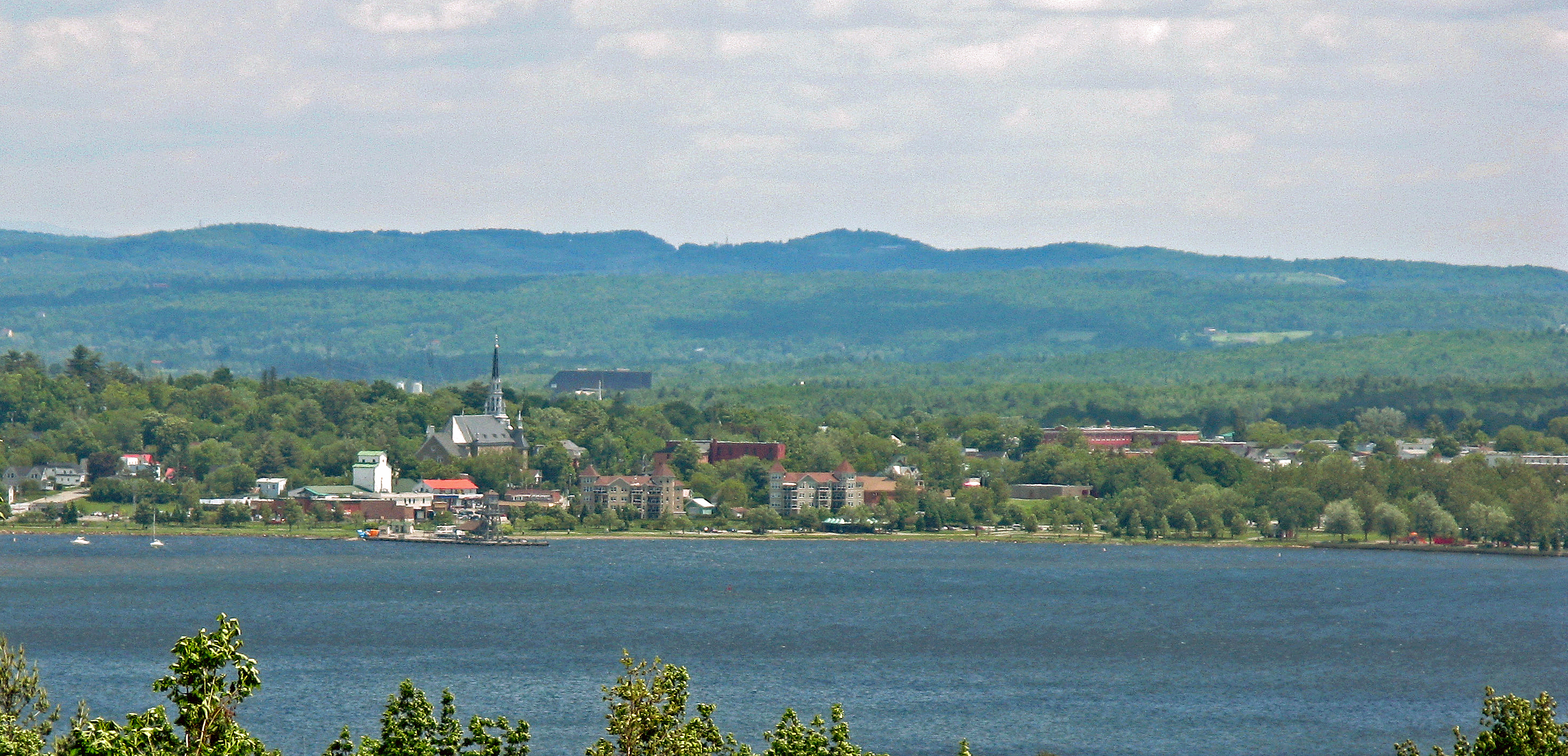
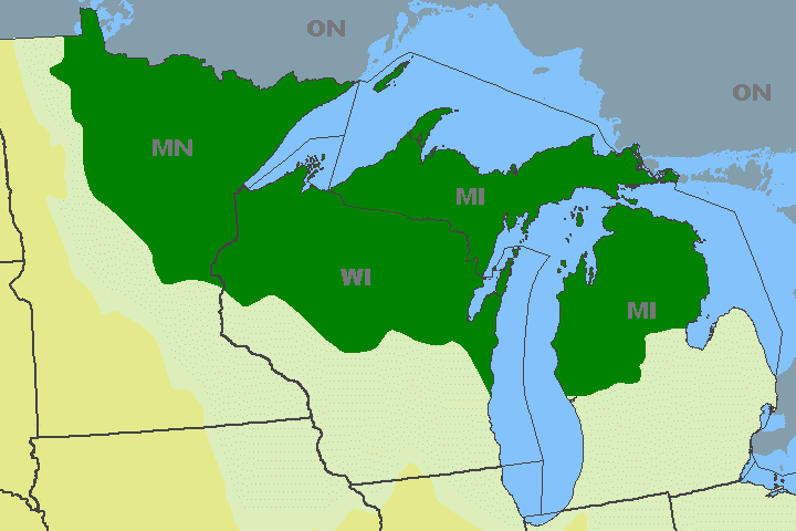
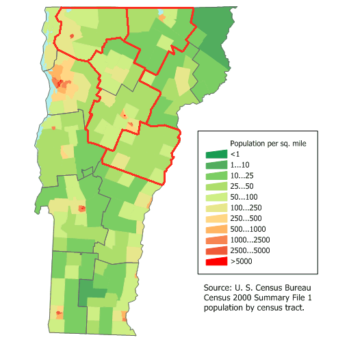
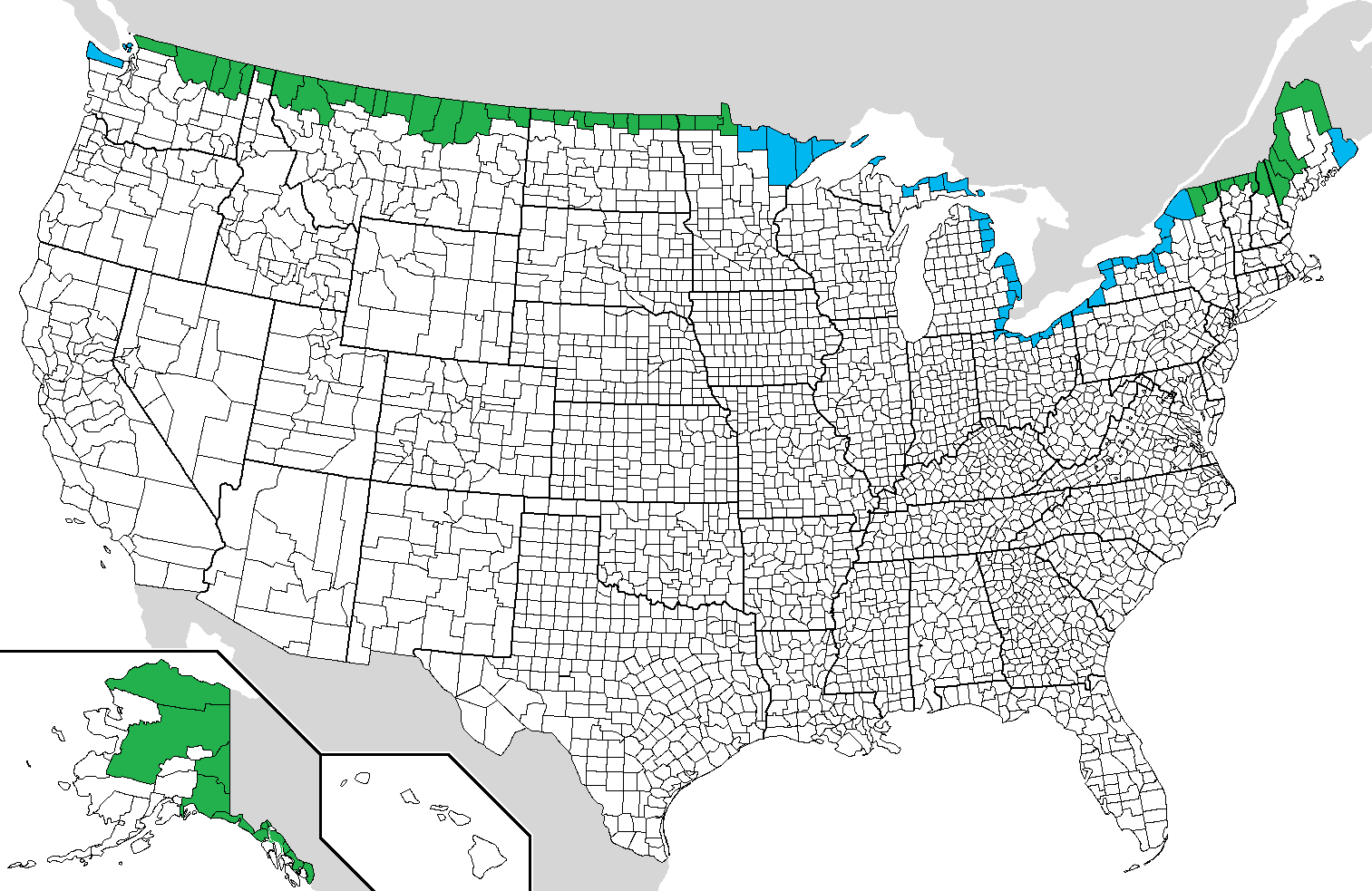
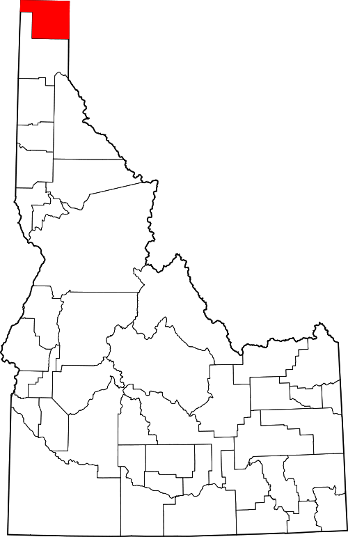
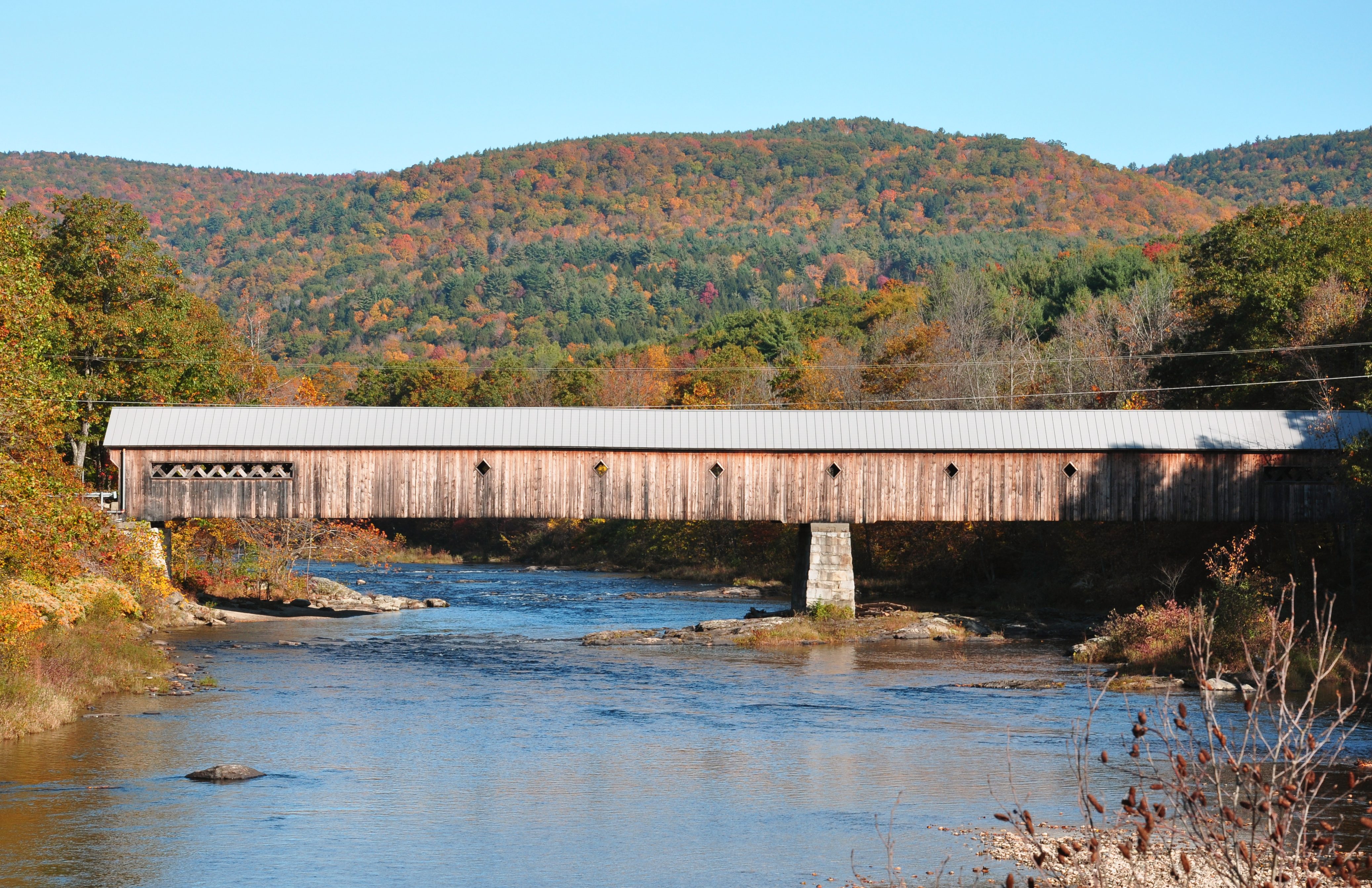
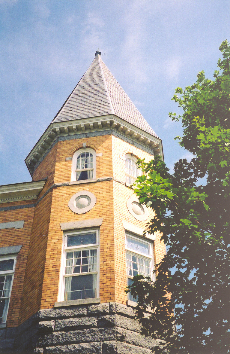
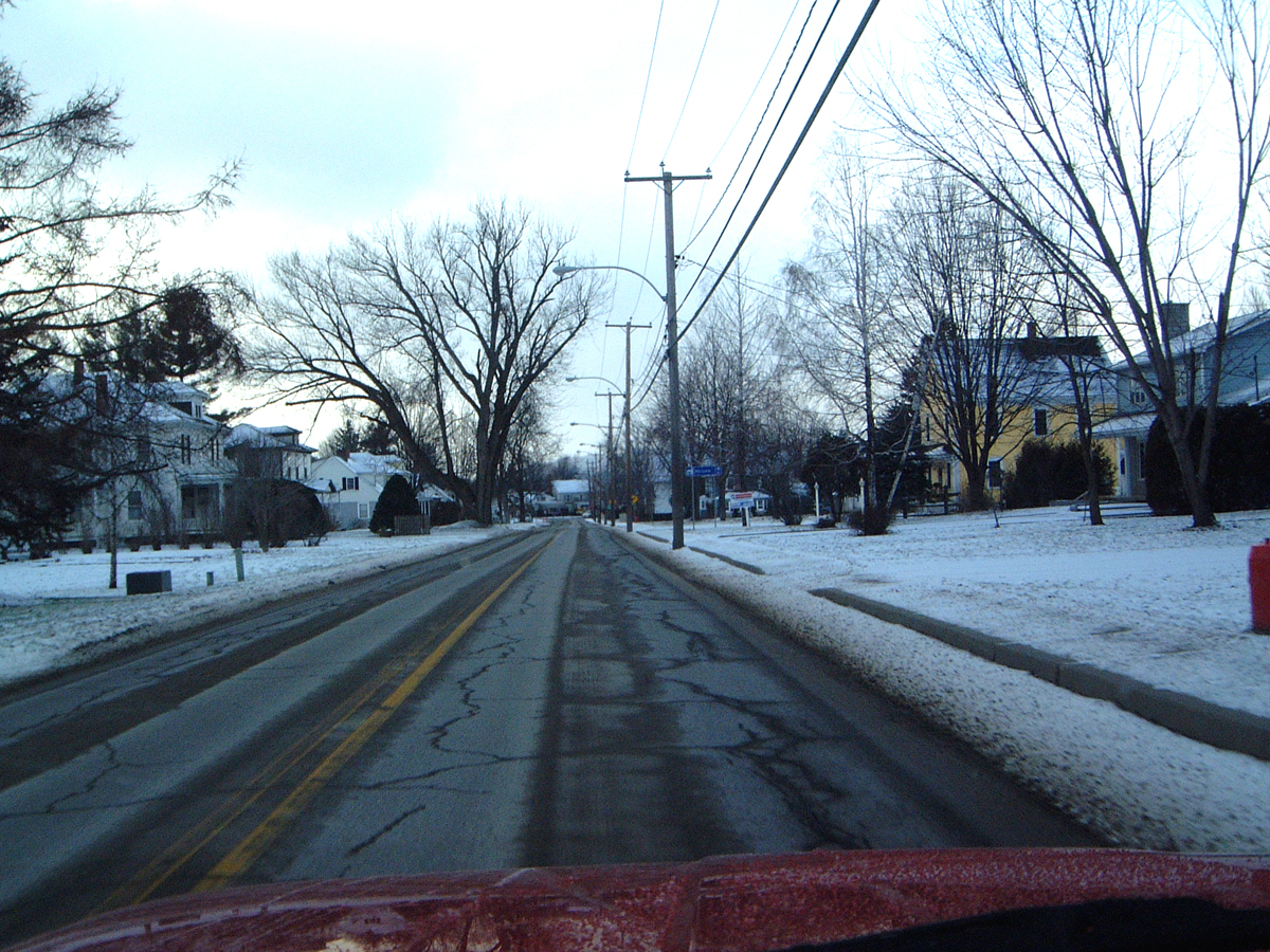
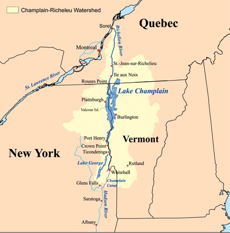