|
Reflections 2011
Series 10
March 18
ENY/Hollis - E Hud. Rail & Sail: BH Circle - Fire Island - East End
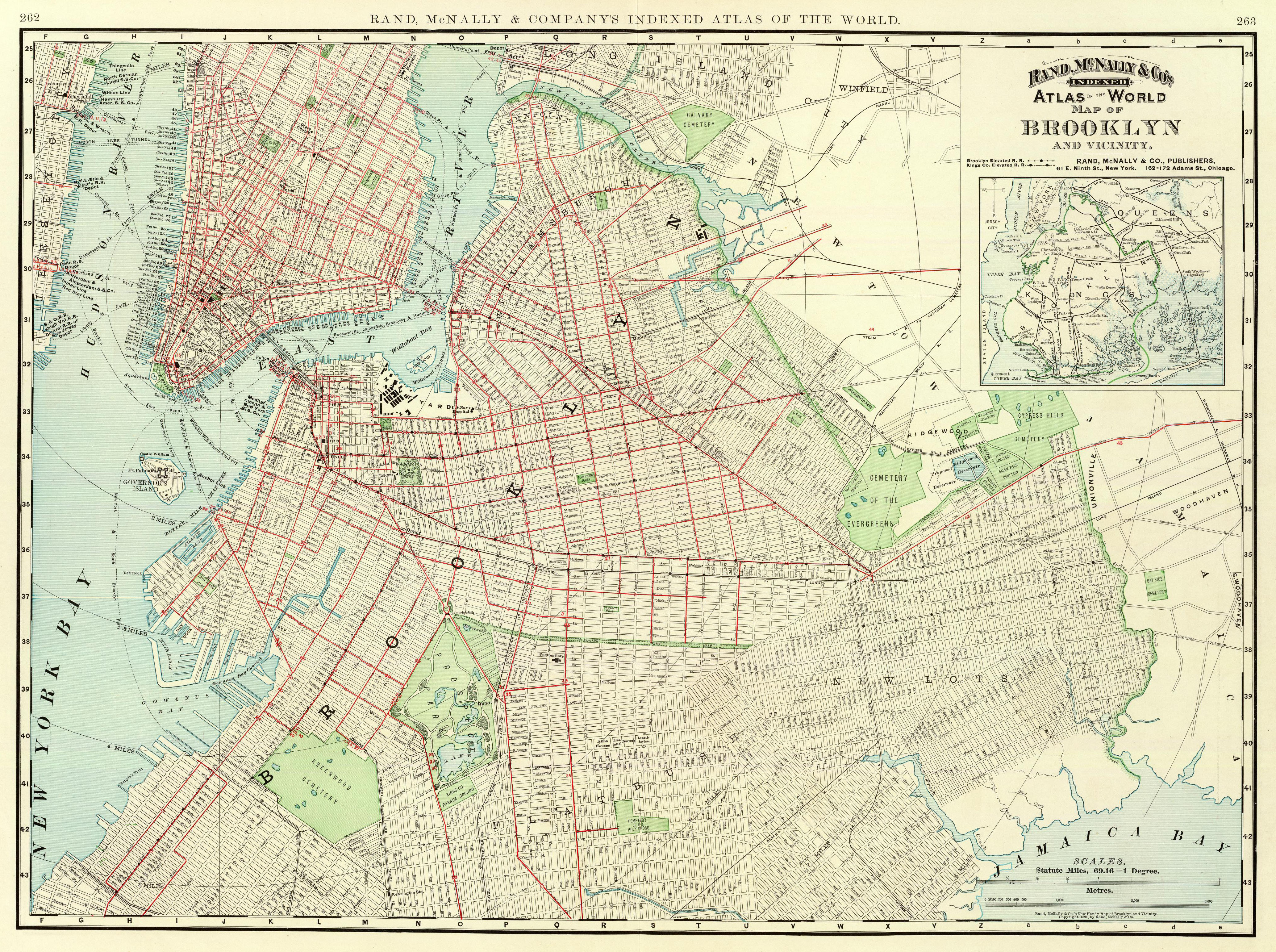
| | East New York In our maps and discussions, we’ve gone forward and back in time. There’s one more map to look at that’s somewhere in the middle. It shows Brooklyn in 1897, one year before consolidation with New York (Manhattan). | | | | Click to enlarge, and look first at the inset on the upper-right. Notice how the Brooklyn Bridge had elevated lines on it to City Hall, and how some of those then ran along Fulton Avenue (as it was then) and Jamaica Avenue to Jamaica, parallel and so close to Atlantic Avenue; find the LI Depot in Hunters Point at the top; notice how the two traditional towns, Bedford and East New York both had other rail connections; and note that all southbound rail connections to Coney Island and Rockaway are now subway lines. Move left and find the Hunters Point Depot and Ferry. The Hudson River Tunnel shown would have been the PATH line a decade later; there’s an interesting ferry connection from Paulus Hook around Manhattan to Fulton Landing; Governors Island is still small.
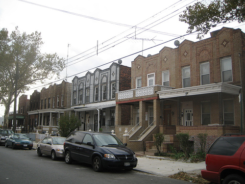
| | | | Back on topic, follow our routes. See how Fulton Street, starting next to what was also called the New York and Brooklyn Bridge, is still intact under its own name, and parallels the LIRR on Atlantic, which starts at this point at Flatbush Avenue. Flatbush Avenue takes off of Fulton at that familiar fork, without the extension having yet been built to the nonexistent Manhattan Bridge. Watch how many routes converge, including Brooklyn’s Broadway, at the former Jamaica Pass, now Broadway Junction, where East New York was born. The old road changes its name here from Fulton to Jamaica Avenue, with the elevated continuing onto “faux” Fulton, but eventually reaching back up to Jamaica Avenue. Jamaica Pass is again where the British marched through in the Battle of LI, and East New York was for a time, the westward limit of steam engines. Let’s have some background. | | | | In 1835, John R. Pitkin from Connecticut bought a large plot of land as a speculative venture, and named it "East New York" thinking that it would become a great city rivaling New York--that’s New York (Manhattan) and not Brooklyn, since he didn’t call it “East Brooklyn”. His plan failed due to the economic depression known as the Panic of 1837, but the name stuck. Some development began in the 1850’s, and by the 1930’s, the residents were chiefly Italians, Russians, Poles, Jews, and Germans. At the Brooklyn Historical Society I found out that the Italians were concentrated along Atlantic Avenue--which I knew, since my father and his family lived there, and the Russians congregated to the southwest of there, which I knew, since that’s where my mother grew up. [On the map, what shows as an undeveloped extension of Eastern Parkway has been Pitkin Avenue for a long time.] | | | | When the LIRR came through the pass, it didn’t at first include a station at ENY, but did begin stopping there in 1843. In 1857, a grain and feed store was built on Alabama Avenue at Atlantic called Howard House, and passengers changing horsecars--several lines terminated there--began to use its porch as a waiting area. Eventually, Howard House became an inn, and the LIRR began stopping there (a dot is on the map), where conductors called out “Howard House, East New York!”. Then, activity improved from 1861 to 1877, when East New York served as the western end of steam service on the line. But by 1878, the ENY Station was shifted four blocks west (see the dot) to what was then a junction with another rail line. (“Plank Road” at that intersection is now East New York Avenue.) This later became the main East New York station, and the one at Howard House closed in 1905. | | | | In ENY, my family lived first on Pennsylvania at Liberty. In 1944, my father held me on his shoulders to see an ill-looking, campaigning Franklin D. Roosevelt ride by in an open car down Pennsylvania Avenue. As for Liberty Avenue, at the Brooklyn Historical Society I recently learned that it got its name because it was the free road that was built for farmers to avoid the toll on Jamaica Avenue. We then moved to Jerome Street between Sutter and Blake, and that’s where I described what the Blizzard of 1947 (2010/25) seemed like to me. I learned long ago about the Jerome family, and Jennie Jerome being Winston Churchill’s mother. Finally, we moved to attractive Arlington Avenue at Miller, where Jamaica Avenue was a short block north, faux Fulton Street was one block south, followed by Atlantic Avenue. I learned at the BHS recently that Arlington Avenue was named after Arlington National Cemetery near Washington. | | | | In the 1950’s the population of ENY changed, as Puerto Ricans and African-Americans started moving in, and a working class neighborhood became a poor neighborhood. Public housing projects further contributed to the decline, and ENY suffered. These are typical ENY rowhouses as I remember them, and many ended up being burned out, with sections looking like a war zone. However, in recent years, reconstruction has been going on, including new subsidized single-family homes being built under the Nehemiah program (Nehemiah rebuilt the walls of Jerusalem). | | | | Notable natives of ENY are composer George Gershwin and his lyricist brother Ira Gershwin, science fiction writer Isaac Asimov, actors Danny Kaye, Tony Danza, Jimmy Smits, and Steve Buscemi, and also a number of contemporary musicians and rappers.
| | | | Hollis We then moved into Queens, to bucolic Hollis. Hollis Station was just over two avenues north of us, but the LIRR was on a massive embankment, and, although Jamaica Avenue (once again) was just two blocks north of the station and four blocks from us, we never felt that the other side was even Hollis. Actually, our street, 195th Street, was the only one for some distance that, at 99th Avenue, went through the embankment, as a pedestrian tunnel, but we rarely had occasion to use it.
| | | | I am only now learning that Hollis was originally settled by Dutch homesteaders in the 17C, and that a Revolutionary War event took place there, when Brigadier General Nathaniel Woodhull was captured and killed at a tavern on what is now Jamaica Avenue. I now know why there’s a Woodhull Avenue north of the embankment. | | | | The area remained rural until 1885, and given the location, both the village and station were called East Jamaica, at which point they were changed to Hollis. The reason was that Frederick Dunton, who was the nephew of the president of the LIRR, was raised in the New Hampshire town of Hollis, just west of Nashua, and just above the Massachusetts border. He liked East Jamaica, where he wanted to develop real estate, but changed its name to Hollis. He built himself a house and started selling plots. He also gave the name Holliswood to the adjacent neighborhood several blocks north of Jamaica Avenue. | | | | At least I can say I’ve been aware of the origin of the name Hollis for some time, but it begs the question, where did Hollis NH get its name? Apparently that also is a vestige of the British. Benning Wentworth was the Royal Governor of the Province of New Hampshire from 1741 to 1766, and he named Hollis NH in 1746 after an ancestor of his, John Holles, one of the Earls of Clare. And an earlier ancestor still was Sir William Hollyes, Lord Mayor of London. | | | | But recent research has led to a small surprise in the form of this 1909 map of Hollis Station. Don’t be confused, because it’s really two maps, the tracks and the north, and then the tracks and the south. Mentally overlay one set of tracks over the other. Sure enough, Woodhull Avenue is there, and Jamaica Avenue is one block further north, off the map. Country Road is now called Hollis Avenue. At the bottom, my 195th Street would be the last one on the right. The underpass where 195th crosses 99th Avenue has apparently not been built yet. But where is 99th Avenue? Why does it say ATLA… in its place? Well, to my surprise, 99th Avenue is another instance of Atlantic Avenue suddenly appearing next to the LIRR--as further east in Floral Park and Carle Place--but then suffering a name change. So I was near Jamaica and Atlantic Avenues in East New York, moved east, and was unwittingly--until now--adjacent to both of them again in Hollis. | | | | Since the 1950’s and 1960’s, Hollis has been settled primarily by middle class African-Americans. Since the rise of hip-hop, Hollis has become a center of rap music. Notable residents have included Art Buchwald and Al Sharpton.
| | | | Brooklyn Heights Circle I did an extensive day trip very near to home centering on BH: Governors Island, BH, and the Brooklyn Bridge. In recent years, the Coast Guard has left the Governors Island, and title was transferred to governmental bodies. The historic northern end is being made into a park, and the rather uninteresting southern end, made up of landfill from the building of the Lexington Avenue Subway, has been proposed to be a convention center, a university, a casino, housing, and more. Anyway, as the warm weather came, the free ferry from the Battery (and I grit my teeth when I call it South Ferry) started running for the season. I would have avoided a weekend, but there is now also a small connecting ferry to Brooklyn which runs only on weekends, so I girded myself for weekend crowds. | | | | I took the free Downtown Shuttle to the ferries, and boarded a Governors Island ferry from the terminal east of the Staten Island Ferry. The crossing on a beautiful mid-June day took minutes, everyone on the rather large boat stood shoulder-to-shoulder, and I will guarantee that I was the only one comparing this crossing to the crossing the Dutch had from the island, their first stop when they first arrived in the harbor, to Manhattan, their final destination. | | | | On this map of Governors Island the difference from the historic area and landfill area to the SW is obvious. One lands from Manhattan at #1, with a view of the ventilation shaft (V) from the Brooklyn-Battery Tunnel below. The whole park was in picnic mode--a woman celebrating her birthday gave me a cupcake--and also had arts and crafts exhibits everywhere. I visited the National Monument historic area: 1798 Fort Jay (# 13) surrounded by a dry moat (# 12); the Parade Ground nearby; Nolan Park, the campus-like setting with the historic Commanding Officers’ Quarters, 15 yellow clapboard houses dating from 1857-1902 (lettered A); opposite was the Colonels’ Row (lettered C); and to the west another fort, circular Castle Williams (1807-1811). I ended up taking the newly-opened (2008) 3.5 km (2.2 mi) promenade around the entire island, with views in every possible direction, ending up at the ferry to Brooklyn (# 14), which was actually one of several smaller NY Waterway ferries pressed into service on summer weekends. Click to enlarge to notice in the picture the Brooklyn Heights Promenade (Esplanade) with the BQE on its “shelves”, as well as the Brooklyn Bridge, since those were my next two destinations on my “marathon” walk. I will give my second ferry guarantee that I was the only one on the ferry who, while it appeared we were just arriving at a pleasant park and playground at the foot of Atlantic Avenue, was aware we were arriving at historic South Ferry (although indirectly from Manhattan), since there was nothing to indicate such, and most people wouldn’t have known the significance (Boston! Atlantic Avenue Tunnel!) anyway. | | | | The piers all along Furman Street below BH between here and Fulton Landing are being rebuilt as Brooklyn Bridge Park, a marvelous development. At first, this picture seems like nothing: winter snow and construction. Well, this is now a grassy park with playground, and represents what Brooklyn’s Pier 5 is turning into. You’ll now see that, just as the previous picture showed where I was headed, this one shows perfectly where I’d just been (and more). Click to enlarge, and focus on the orange Staten Island Ferry at its slip in Manhattan; the three arches are the slips in the Governors Island Ferry Building I’d just been in. Above a white boat in the harbor is Ellis Island, recognizable by its four pointed towers. Much more obvious is the Statue of Liberty; then comes circular Castle Williams and the rest of Governors Island, with the Bayonne Bridge to Staten Island in the background, and finally is the lovely (!!!) ventilation shaft of the tunnel. These last two pictures together sum up my entire day. | | | | Just a bit up Atlantic Avenue is Columbia Street, where the now invisible Atlantic Avenue Tunnel used to exit, and then the viaduct of the BQE. Two more blocks and a left onto Henry Street has me climbing the southern slope of Brooklyn Heights and into its 1965 historic district, which retains its serene, upper-middle-class atmosphere. I stopped on Henry and Remsen to see the exterior of Our Lady of Lebanon Maronite RC Cathedral, which is the repository for the bronze medallions to the doors to the dining room of the Normandie (2010/1). The fate of the two 6 m (20 ft) doors is unknown, but their five medallions each were purchased for the church, six on the Henry Street doors and four on the Remsen doors. Click to enlarge, and it’s like being there.
| | | | After a walk on the esplanade for the view, I went up Hicks to Orange to see the Plymouth Church of the Pilgrims (it wasn’t winter), the pulpit of abolitionist Henry Ward Beecher, and a stop on the Underground Railroad. He’s the brother of Harriet Beecher Stowe who wrote Uncle Tom’s Cabin. At Hicks and Cranberry I checked out Jack the Horse Tavern, which I liked enough to have gone to with friends three times later during the year. I had to ask about the name, and it turns out it’s named after Jack the Horse Lake, to which the owner has some connection, in Minnesota, just north of Grand Rapids.
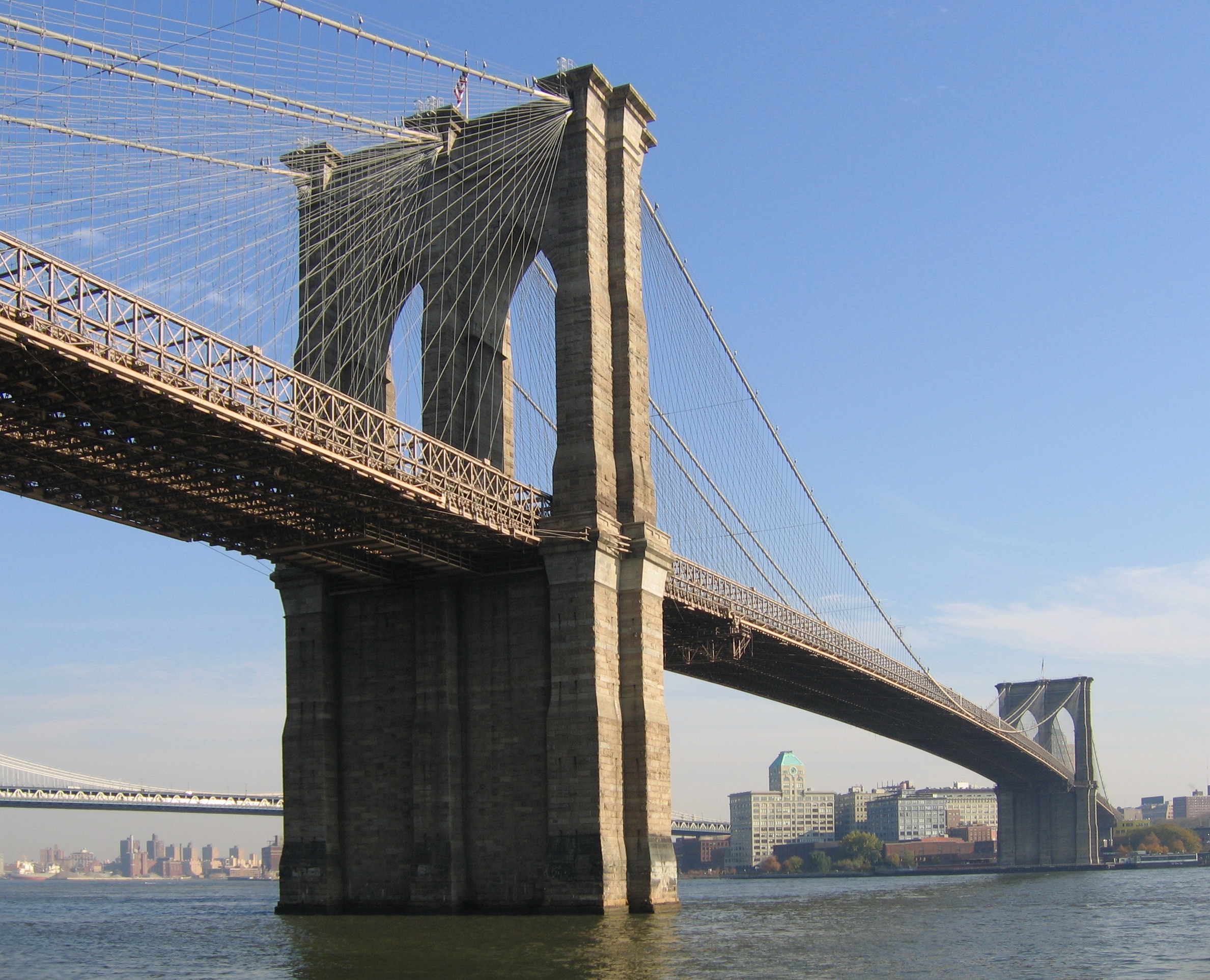
| | | | Descending BH to the north I walked around Old Fulton Street, the pier, and new parkland just opened adjacent to it, and then proceeded to the stairway up to the pedestrian walkway over the Brooklyn Bridge (here the view toward Brooklyn, with the Manhattan Bridge. Click to enlarge to see the restaurant at Fulton Landing). I’d walked the bridge twice before, once as a teenager, and once with Beverly, and it was time to do it again. The walkway was busy with others doing the same, including people from outside the US, judging by languages heard. The walkway is a gala of cables, leading through those iconic gothic towers. The walkway is in the center, above roadway traffic below, which is on both sides.
| | | | You can today only get an idea of the huge size of the bridge when you compare it to something at its foot like Fulton Landing (above). One indication of size is an earlier name, the Great East River Bridge. Today, Manhattan has grown so much that one doesn’t realize that one used to be able to see over Manhattan to New Jersey from it. This nighttime view from the Brooklyn side shows the wall of the skyline blocking any distant view. Now compare this Currier & Ives lithograph from 1883, and you’ll see the hugeness of the bridge. Click for detail, and you will be amazed to find, under the center of the bridge, the steeple of Trinity Church on Broadway, as it faces down Wall Street. You’ll also see the Catherine Street Ferry to the right of the Bridge, and the Manhattan landing of the Fulton Ferry to the left of the Bridge. Currier & Ives were so good at detail, that you’ll not only see Governors Island on both sides of the Bridge’s left pier, you can make out round Castle Williams on the right. And behind are the hills of Staten Island. And don’t forget to look at the people walking the Bridge, then, as now. | | | | [AN ASIDE ON CURRIER & IVES: I only now discover that this printmaking firm that so defined American life in the late 19C with their lithographs, started out being New York based (and we noted they’re both buried in Greenwood Cemetery), working from 1834 to 1907. Based on paintings, they produced prints as black-and-white lithographs, quick and inexpensive to produce, which were then hand-colored, until full-color lithography became available. Nathaniel Currier was the founder of the firm, and he had early success with prints of tragedies, particularly fires, which sold readily. One has to realize there were no news photos for the public to rely on. In 1857, he asked James Merritt Ives, his bookkeeper and accountant, to be his partner, and also manager of the firm. They published at least 7,200 lithographs in the 72 years the firm was active, depicting American life. Two of their prints involving New York City are Central Park in Winter (1862) and View on the Harlem River (1852). The Victorian public, given its interest in current events and sentimental taste, appreciated Currier & Ives prints, which became among the most popular wall hangings of the day.] | | | | It is with this background, plus our extensive review of routes in Brooklyn that I present a most enjoyable Currier & Ives print of Brooklyn in 1879. Clicking reveals the most exquisite detail--just read the signs along the BH waterfront. This is like a 19C Google Street View. Most enjoyable is to see that towns do not run together; there’s still green space between them. | | | | The only inaccuracy I can see is excusable--this is 1879, but Currier & Ives were anticipating the completion of the Brooklyn Bridge in 1883. Look at the vehicles on it. To the left of the bridge is Wallabout Bay and the Navy Yard. The Manhattan Bridge isn’t there yet with its Flatbush Avenue Extension, nor is the Williamsburg Bridge, but you can clearly see Broadway, the road that today connects with that bridge.
| | | | Go to Fulton Landing and see Fulton Street lead away, and on the other end of BH is South Ferry and Atlantic Avenue, with the tracks already gone. Both roads lead away together to the distance, first to nearby Bedford, then, remarkably, to freestanding East New York on the horizon, as confirmed by the text at the bottom of the map (along with other landmarks). | | | | In the middle of BH was a surprise for me, what turns out to be a ferry from Wall Street to Montague Street. How could that be, given the bluffs? It turns out the Brooklyn Heights Railroad was a street railway company that started out with a Montague Street Line, a short cable car line connecting the Wall Street Ferry with downtown Brooklyn along Montague Street. Incredible! A BH cable car! And it’s all gone. | | | | Governors Island shows its two monuments; Hamilton Avenue above it doesn’t have a tunnel exit or expressway on it, but does have its ferry; Red Hook has a nascent Atlantic Basin with a ship, and the Gowanus Creek is beyond. In the right rear, the lakes identify Prospect Park, out in the countryside, with Grand Army Plaza at its entrance and Flatbush Avenue beside it. On the right is Greenwood Cemetery, also surrounded by greenery. A number of railroad lines can be seen on their way to Coney Island. | | | | Fire Island As mentioned earlier when discussing the LIRR Montauk Line, I said I took two trips on it in 2010. One was about half,, the second the entire length of Long Island, which extends eastward from New York harbor 190 km (118 mi) to Montauk Point, making it both the largest and longest island in the contiguous US. LI is 90% the size of Rhode Island. LI’s maximum N-S width is 37 km (23 mi). With a population of about 7.5 million, it is also the most populous island in the US, and is more populous than Ireland, Jamaica (the irony!), and Hokkaido.
| | | | There follows a link to a website called loving-long-island.com, for readers to look at their very clear and simple map of Long Island. Their only error is not coloring the Rockaway peninsula yellow as part of Queens. Fire Island, out in Suffolk County, can be found among the other barrier islands on the South Shore. Here is more of a detailed map (click to enlarge), which shows the FI National Seashore areas, the two bridges out to the island accessing only the parks at either end, plus the communities lined up along its narrow width, accessible from the mainland only by ferry across Great South Bay. (It seems odd to call LI a mainland, but that’s what it serves as here.) FI is 50 km (31 mi) long and only 100-400 m (325-1300 ft) wide. | | | | I’d say I’d never been to Fire Island, but that wouldn’t be exactly true. Some years ago, Beverly and I drove over the causeway to the state park at the western end and stopped at the nude beach there for a couple of hours. But that’s a world apart from the communities along the length of the island that are totally carless, a pedestrian’s paradise. So, keeping these two different worlds in mind, I’ll say I’ve never been to the “real” Fire Island. But there was a choice of which community to try: there’s Ocean Beach, Saltaire, and others toward the west, accessible from Bay Shore, and Cherry Grove (“The Grove”) and Fire Island Pines (“The Pines”) in the center, accessible from Sayville. (Patchogue also has a ferry.) Research was necessary to see what intrigued me most.
| | | | Why is it called Fire Island? It remains unclear--some sources say colonists saw Native Americans building bonfires, which sounds fanciful to me--but the story that seems to have some merit involves Dutch once again. At the western end is Fire Island Inlet, which a storm broke through in 1683. There were either four or five small islands (barrier islands come and go) at the inlet, and Dutch sailors navigating the inlet into the bay referred to either vier (“four”, sounds like “fear”) or vijf (“five”, rhymes with “safe”) islands to watch out for. It is possible that “fear” and/or “fafe” turned into “fire” in the ears of English speakers, via the process of folk etymology. In any case, the name “Fire Island” first appeared on a deed in 1789. | | | | The first large house on Fire Island was built in 1795 in Cherry Grove. In 1868, Archer and Elizabeth Perkinson bought land around The Grove and The Pines and built the Perkinson Hotel in 1880. In 1882, Oscar Wilde purportedly stayed at the hotel for a few days, but that might be more of an fanciful legend than fact. In 1909 Ocean Beach was established, and in 1910, Saltaire. The Pines, a latecomer, was not developed until the mid-1940’s.
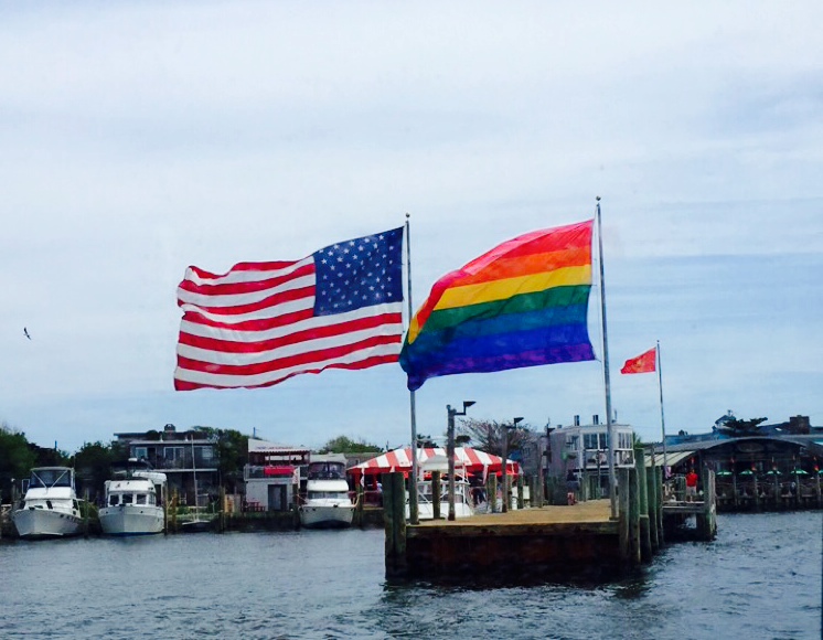
| | | | The Great Hurricane of 1938, the first major one to strike the Northeast since 1869, devastated Fire Island: they say it’s what took out the grove of wild cherry trees that gave Cherry Grove its name. The negativity of the destruction made going there undesirable. Just as a real estate crash in Harlem in 1904 created a vacuum that was filled by African-Americans moving into the neighborhood in large numbers, the sudden undesirability of Fire Island after the 1938 hurricane was replaced by gays filling the vacuum. Gays started arriving in numbers and concentrated in Cherry Grove, including literary luminaries such as Christopher Isherwood and W H Auden. Fire Island Pines, always the latecomer, also became a gay haven starting in the 1960’s. I’d also read that the Grove is known for a very tolerant mix of some straights and straight couples, along with gay men and women. | | | | So the choice was easy. While all the communities have the summer beach culture, only Cherry Grove has the history, the friendly atmosphere, and the diverse lifestyle--to say nothing of a guest house to bowl you over--to make it the most interesting-sounding destination. I was less interested in the Pines, but also wanted to visit it. | | | | This was to be entirely a rail & sail trip, plus lots of walking. I had gone to Governors Island last year in mid-June, and followed that with a trip to Fire Island in late June. I took the LIRR to Sayville, where vans meet every train to take passengers down to the ferry, at $5 for the ten-minute trip. The crossing of Great South Bay covers 8.9 km (5.5 mi) to the dock in Cherry Grove (Photo by Dinker022089). | | | | The layout of Cherry Grove is simple, which is one of its charms. There’s a walk each on the bay side (Bayview Walk) and on the ocean side (Lewis Walk), linked by some 16 connecting walks. Coming right off the dock, Ocean Walk, at the intersection of Bayview, is the business district, with the restaurants. You can take a longish walk through the sandy woods to the Pines if you wish. | | | | There is a very good reason why these are not called streets, but walks (Photo by Bearian), as at this intersection. Every single one is a ground-level boardwalk. There are perhaps 300-350 houses in the hamlet, many with amusing--really amusing--names. They are vacation homes, and out of season, maybe a dozen people live here, growing to maybe 2000 in season. The ocean beach is bordered by dunes, which are protected by wooden staircases over them. The dunes tend to block ocean views, but the bay views, which face the sunset, are spectacular. | | | | Wikipedia says there are three massive homes in the Grove, Belvedere, Bottom of the Garden, and Cielo e Mar (Sky and Sea). I never found the last two, but I stayed in the over-the-top Belvedere. It’s almost at the end Bayview Walk, on the bay side between Maryland and Sumner, so it not only has views, but is immediately visible from the arriving ferry. It’s all fountains and statues, Rococo, Victorian, what have you. Off an internal garden I had a very quiet room called the Venetian, which had just that, Venetian décor. | | | | It was a short walk to the clothing-optional beach, and while the weather was still chilly, it was worth a visit. The Belvedere does not serve breakfast, and everyone goes down to Floyd’s to sit outside at benches, and where the atmosphere is super-cordial. I enjoyed the Top of the Bay (Zagat listed) and Island Breeze restaurants, which are on either side of the dock, where there were swans swimming--last year they counted 27.
| | | | One afternoon I did hike for a half hour, largely through sand, to walk over to the Pines. Legend has it that a 19C ship foundered here depositing a load of Christmas pine trees, but you can take that for what it’s worth. The Pines is supposedly more urbane, and its 700 homes are the most expensive real estate in FI. The summer population rises to 2500-3000, less diverse, and mostly gay male. Maybe because I didn’t expect it to impress me, it didn’t. It does have a pretty marina surrounded by shops that look like a mall, but I saw few people, and didn’t experience the warmth here I found in the Grove, which is the place to go. | | | | The East End and the Hamptons The longer trip on LI was out to the East End. On the earlier linked map, note the North Fork, with its wineries, extending to Orient Point, and the South Fork, including the Hamptons, extending to Montauk Point. (There are also wineries on the South Fork.) Between the forks is Shelter Island, which, with the two Forks, encloses the (here unnamed) Great Peconic Bay. The Hamptons extend as indicated, between Riverhead and Montauk, just before Montauk Point. But between where it says “The” and “Hamptons” is a narrow isthmus bisected by the 1892 Shinnecock Canal, and between the barrier islands below is Shinnecock Inlet, and these two waterways linking the bay with the ocean tend to limit peoples’ concepts of the Hamptons as being just east of them. This is similar to how the Cape Cod Canal tends to define where Cape Cod starts. | | | | I did this trip to a guest house in East Hampton earlier than the others, in the second week of May last year, pre-season, and quiet. However, I was fixated on going to the end of the line, so I took the LIRR via Westhampton and Hampton Bays, two communities west of the Shinnecock Canal and Inlet, via prestigious Southampton and Bridgehampton, not to tony East Hampton, but right through it to Montauk, a total ride of 3h7m. [In the late 19C, the LIRR was extended from Bridgehampton to Montauk where a transatlantic seaport was planned that never panned out. An interesting concept: a longer rail trip to shorten the “sail” trip.] Only then did I take the returning train back about 15 minutes to East Hampton. | | | | I found East Hampton, founded in 1648, eminently walkable in a small-town way. The station was at grade level, so tracks kept crossing streets. My guest house was just a couple of blocks from the station. It being pre-season, I was the only guest (there were only two other rooms) until the last morning. It was a handsome house, although not a showcase, with a living room area downstairs, and nice rooms upstairs. I could buy my Times every morning near the station, and walk to Main Street. Perhaps in season there may be some celebrities (but then New York has them, too), yet the only notable upscale note I saw was a small Tiffany’s shop. I walked down to the Maidstone Inn for a very nice dinner, and one evening met friend Bob, who calls himself Montauk Bob, for dinner. | | | | As in Spring Lake, getting a car was not easy. I’d had to book one at East Hampton Airport, and had to take a taxi to get it, and then again a few days later, after returning it. My first drive was a counterclockwise loop to the north. Just above East Hampton is the old whaling port of Sag Harbor, from where a car ferry crosses over to Shelter Island. Another ferry then crosses over to Greenport, settled in 1682, on the North Fork. Right where the ferry lets you off is the Greenport LIRR station, end of the line. At this same Shelter Island ferry dock was where the old ferry service to Boston picked train passengers up stepping off the adjacent train platform. But then I drove about 15 minutes further out to Orient Point, from where the present car ferry to Connecticut leaves. This will be the connection I’ll try to make next summer. This aerial view shows Orient Point (the ferry leaves from the south side of the very tip) facing Plum Island NY, with Connecticut to the north.
| | | | Continuing west along the North Fork there seems to be nothing but wineries. The first winery just opened in 1995, and today there are 26. I stopped just at one for a tasting, the Sherwood House Vineyards. Beyond Riverhead, I headed through Westhampton Village to the beach to see the Shinnecock Inlet, which was cut through the barrier beaches by the Great Hurricane of 1938. Further north, I stopped at the park adjacent to the Shinnecock Canal (here looking north into Peconic Bay). It has a lock (here under a roadway and the rail line), not because of a difference in land height but because of tides. The tide in the Peconic Bay can be one meter/yard higher than in the adjoining Shinnecock Bay (leading out the inlet), since the two bays have different tide cycles. | | | | Nearby is Southampton, known for old money and huge estates. (East Hampton is trendy, and known for new money.) It was on an historic marker here that I first learned about the East End being settled from New England, and having an English language tradition from the start, not a Dutch one. Southampton, settled in 1640, is the oldest English settlement in New York State, since it wasn’t founded on Dutch foundations. I drove around Dune Road, the estate area on the south side of town near the ocean. Actually, you can’t see all that much, since the large estates are all behind huge hedges.
| | | | There are some vineyards on the South Fork, and I was referred to one of the best, the Wölffer Estate Vineyard, about 20 years old, built on a former potato field (“Long Island potatoes”). The tasting room is baronial, and I paid for a tasting with cheeses. One notable wine was Merliance (“merlot alliance”), which is a merlot including blends from an alliance of four North Fork vineyards, and I was surprised that one of them was Sherwood, which I had just visited. I tasted a “faux” ice wine, which they can’t legally call an ice wine, since it’s not cold enough in November when the grapes are ready, so they have to freeze the grapes mechanically. Wölffer has served at two White House dinners, including one in the late ‘90’s for then German Chancellor Gerhard Schröder.
| | | | I left for its own day my run out to Montauk Point. Past Amagansett, it was again at a roadside marker where I first learned about the Napeague Isthmus I was driving over, and how all of Montauk had been an island five thousand years ago until silting sands connected it to the Amagansett area via the isthmus. Oddly, the Great Hurricane of 1938 flooded over the isthmus, making Montauk temporarily an island again. I later stopped at the famous Gurney’s Inn, founded in 1926 by Maude Gurney and her husband, but run since 1956 by the Monte family.
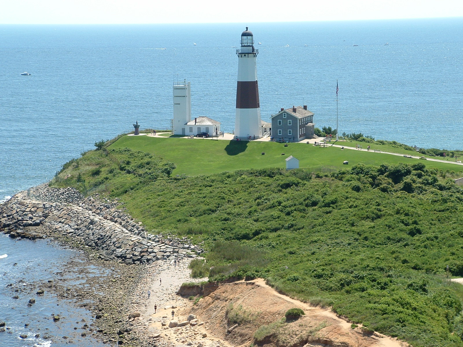
| | | | I stopped in the village of Montauk for a bite to eat. In contrast to the Hamptons further west, Montauk is laid-back, and relishes its position on the tip of the island, set apart from the more exclusive villages. I like to read James Patterson mysteries, and he wrote two excellent ones about and in Montauk, “Beach House” and “Beach Road” (there really is a Beach Road, which I sought out to visit). Also, in 1975, Swiss author Max Frisch wrote “Montauk”, which is not fiction, but discusses a real-life affair he had here with a female journalist. | | | | I then went out to the Ultima Thule, Montauk Point with its lighthouse. George Washington authorized its construction in 1792. It was the first in NY State, but even the Montauketts built watch fires to guide canoes safely home. The light is now automated and still under Coast Guard jurisdiction, but the lighthouse itself has been given over to the Montauk Historical Society. They have excellent displays in the lighthouse keeper’s former house, and this was where I first learned about the fact that there are TWO moraines along LI and that they connect to New England. I also climbed to the top of the lighthouse for the excellent view in every direction. | | | | Carl Fisher was the man who, starting in 1910 through the 1920’s, took a mangrove swamp off Miami and developed it into an exclusive resort, which became the City of Miami Beach. In 1926, he then he turned his attention to Montauk, which he wanted to develop into a warm-weather counterpart, the “Miami Beach of the North”. It was to be expensive and exclusive, and its slogan was to be “Miami in the winter, Montauk in the summer”. He did manage to complete some projects, such as a golf course, yacht club and marina, playhouse, and a six-story office building, unusually tall for the area. But following huge financial reversals, including the collapse of the Florida real estate market, the devastating 1926 Miami Beach hurricane, and the 1929 stock market crash culminating in the Great Depression, the Montauk project collapsed and went into receivership in 1932. Actually, the founding of Gurney’s Inn by the Gurneys in 1926, was a related event, since the Gurneys had managed a Fisher hotel in Miami Beach.
| | | | An “improvement” Fisher did that remains today was not environmentally sound. The Great Pond was the largest freshwater lake on Long Island. He permanently blasted an opening to the sea to the north as part of his Montauk resort plans, and it is now saltwater Montauk Harbor, called Lake Montauk. I drove around it to inspect what it is and what it had been. As it turns out, by 1989 it became the largest commercial fishing port in NY State. | | | | But one addition that also remains is really quite spectacular. High on a hill with water views he built in 1926 a three-story 200-room resort hotel in Tudor Revival style called Montauk Manor, which today is the Montauk Manor Condominium Resort Hotel, and on the National Register of Historic Places. I visited it, and enjoyed the public rooms on the ground floor, including the baronial lobby. (Rest rooms at the Manor are labeled “Lords” and “Ladies”.) It had gotten chilly, so I got my NY Times from the car and read it in front of a roaring fire in a huge Tudor fireplace. Actually, when I arrived on my first day at the end of the train line, I’d seen Montauk Manor above the Montauk train station, and had wondered why the area around the station was so deserted, except for the Manor up on the hill. Why wasn’t the station in town? Only now do I learn that flood waters from the Great Hurricane of 1938 had inundated the downtown of Montauk and it was moved 5 km (3 mi) to the south, beside the Atlantic. | | | | In the lobby of Montauk Manor hung a vintage travel poster from 1929 that had been commissioned by Carl Fisher, for which they were selling limited-edition reprints. I agreed with their ad calling it “an artifact of American ephemera that captures the spirit of Long Island and the East End’s heritage”. The poster was stunning, but I’ll just quote the text here in closing. Above the illustration, it said: | | | | | | 125 miles out in the cool Atlantic!
On the slender tip of Long Island, NY
|
| | | | And at the bottom: | | | | | | The Gateway to Montauk
The Pennsylvania Station in New York City
Reached by the Deluxe Trains of the Pennsylvania Railroad
Making Direct Connection with Fast
Pullman Parlor Car Trains
Of the Long Island Rail Road
|
| | | | It was really a sign of its times, no pun intended. | | | |
| |
|
|
|

